
Hero image 0 of Topographical Map - Great Smoky Mountains National Park Quad - USGS 1950 - 29.28 x 23 - Vintage Wall Art, 0 of 5
Topographical Map - Great Smoky Mountains National Park Quad - USGS 1950 - 29.28 x 23 - Vintage Wall Art
(No ratings yet)
Topographical Map - Great Smoky Mountains National Park Quad - USGS 1950 - 29.28 x 23 - Vintage Wall ArtTopographical Map Great Smoky Mountains National Park Quad USGS 1950 29 28 x 23 Vintage Wall ArtTopographical Map Great Smoky Mountains National Park Quad USGS 1950 29 28 x 23 Vintage Wall ArtTopographical Map Great Smoky Mountains National Park Quad USGS 1950 29 28 x 23 Vintage Wall Art
Key item features
- OWN A HISTORICAL TOPOGRAPHICAL MAP TODAY - Topographical maps provide you a birds-eye view of how the topography of certain pieces of land are mapped out. See how much today's maps have changed from centuries ago. See how waterways have shifted, or how forrests have become thralling cities. See how history has changed the landscape with a topographical map today!
- TOPOGRAPHICAL MAPS PROVIDE IMPORTANT INFORMATION -Topographical maps show you how the borders of a county are established and were they can be found. It also highlights rivers, mountains, and other natural elements, and it will show you where the cities are located within it.
- ONLY ACCEPT THE BEST PRINT QUALITY FOR YOUR REPRODUCTIONS - There are many printers and print types available on the market, when purchasing a reproduction there is no finer quality reproduction than a reproduction using the Giclee Printing method. Giclee describes the technique or style of printing used, and it is revered as the highest quality printing because of the way it precisely sprays ink onto a surface. Trust nothing less than the best!
- GUARNANTEED TO GET EXACTLY WHAT YOU ORDERED - This map comes exactly to the specification of 29.28 x 23.00 inches/74.37 X 58.42 cm. All of our maps come rolled, wrapped, and shipped in a heavy gauge mailing tube to ensure it arrives intact.
- WHY CHOOSE MAPS OF THE PAST? - Maps of the Past is one of the single largest producers of different types of maps. They legally own the rights to the maps they sell, and provide them to you in clean, clear, and vibrant print. If you are looking for a high quality map print, then look no further than Maps of the Past!
Specs
- Size29.28 x 23
- MaterialCanvas, Paper
- Decor styleVintage
- ThemeHistoric Topographic Maps
- ShapeRectangle
- Art typePainting
Price when purchased online
Not Available
How do you want your item?
Not available
About this item
Product details
Topographical Map Print - Great Smoky Mountains National Park 1950 - This is an exquisite full-color Reproduction printed on high-quality gloss paper, art paper or canvas.
Print Size: 23.00 x 29.28 inches
74.37 X 58.42cm
Sites and Townships Specific To This Map Are: Beard Cane Mountain, Pine Mountain, Bear Pen Gap, Turkey Knob, Balsam High Top, Mt. Le Conte, Hurricane Mountain, Sheepback mountain, Savannah Ridge, Pigeon River, Pretty Hollow Creek, Tuckasegee River and Gregorys Cave.
The following towns are featured: Gatlinburg, Chilhowee, Calderwood, Bryson City, Round Hill, Almond, Sylvia, Addie and Balsam.
This Map is Situated in: Jackson County, Graham County, Haywood County, Sevier County, Swain County, Blount County, and Monroe County in Tennessee (TN) and North Carolina (NC)
SKU: NCZZ0007
Original Maps are often difficult to find and usually have fold lines, identifying stamps or markings, tears, ragged edges, and assorted other natural signs of age that detract from their beauty. All of our maps have been professionally restored to depict their original beauty, while keeping all historical data intact.
These maps are fabulous pieces of history full of information useful to Historians, Genealogists, Cartographers, Relic Hunters, & Others. They make fascinating conversation pieces and splendid works of art for the home or office.
- OWN A HISTORICAL TOPOGRAPHICAL MAP TODAY - Topographical maps provide you a birds-eye view of how the topography of certain pieces of land are mapped out. See how much today's maps have changed from centuries ago. See how waterways have shifted, or how forrests have become thralling cities. See how history has changed the landscape with a topographical map today!
- TOPOGRAPHICAL MAPS PROVIDE IMPORTANT INFORMATION -Topographical maps show you how the borders of a county are established and were they can be found. It also highlights rivers, mountains, and other natural elements, and it will show you where the cities are located within it.
- ONLY ACCEPT THE BEST PRINT QUALITY FOR YOUR REPRODUCTIONS - There are many printers and print types available on the market, when purchasing a reproduction there is no finer quality reproduction than a reproduction using the Giclee Printing method. Giclee describes the technique or style of printing used, and it is revered as the highest quality printing because of the way it precisely sprays ink onto a surface. Trust nothing less than the best!
- GUARNANTEED TO GET EXACTLY WHAT YOU ORDERED - This map comes exactly to the specification of 29.28 x 23.00 inches/74.37 X 58.42 cm. All of our maps come rolled, wrapped, and shipped in a heavy gauge mailing tube to ensure it arrives intact.
- WHY CHOOSE MAPS OF THE PAST? - Maps of the Past is one of the single largest producers of different types of maps. They legally own the rights to the maps they sell, and provide them to you in clean, clear, and vibrant print. If you are looking for a high quality map print, then look no further than Maps of the Past!
info:
We aim to show you accurate product information. Manufacturers, suppliers and others provide what you see here, and we have not verified it.
Specifications
Size
29.28 x 23
Material
Canvas, Paper
Decor style
Vintage
Theme
Historic Topographic Maps
Similar items you might like
Based on what customers bought
Topographical Map - Vishnu Temple Arizona Quad - USGS 1962 - 23 x 28.83 - Vintage Wall Art $94.95 $94.95/count
 $9495current price $94.95$94.95/count
Topographical Map - Vishnu Temple Arizona Quad - USGS 1962 - 23 x 28.83 - Vintage Wall Art
Historic State Map - Nebraska - Colton 1855 - 28.19 x 23 - Vintage Wall Art $94.95 $94.95/count
 3 optionsAvailable in additional 3 options$9495current price $94.95$94.95/count
Historic State Map - Nebraska - Colton 1855 - 28.19 x 23 - Vintage Wall Art
Historic State Map - North Carolina - Morse 1845 - 23 x 29.34 - Vintage Wall Art $94.95 $94.95/count
 3 optionsAvailable in additional 3 options$9495current price $94.95$94.95/count
Historic State Map - North Carolina - Morse 1845 - 23 x 29.34 - Vintage Wall Art
Historic State Map - Grand Canyon Visitors Brochure - US Park Services 1977 - Vintage Wall Art $40.95 Was $94.95 $40.95/count
 $4095current price $40.95, Was $94.95$94.95$40.95/count
Historic State Map - Grand Canyon Visitors Brochure - US Park Services 1977 - Vintage Wall Art
Historic State Map - Pennsylvania County Oil Districts - Colton 1865 - 28 x 23 - Vintage Wall Art $94.95
 3 optionsAvailable in additional 3 options$9495current price $94.95
Historic State Map - Pennsylvania County Oil Districts - Colton 1865 - 28 x 23 - Vintage Wall Art
Historic State Map - California - 1650 - 23 x 32.68 - Vintage Wall Art $94.95
 $9495current price $94.95
Historic State Map - California - 1650 - 23 x 32.68 - Vintage Wall Art
Topographical Map - Yellowstone River Montana Aeronautical Sheet - USAF 1961 - 23 x 30.17 - Vintage Wall Art $45.95 Was $74.95
 $4595current price $45.95, Was $74.95$74.95
Topographical Map - Yellowstone River Montana Aeronautical Sheet - USAF 1961 - 23 x 30.17 - Vintage Wall Art
Topographical Map - Roseburg Oregon Quad - USGS 1967 - 23 x 29.77 - Vintage Wall Art $94.95
 3 optionsAvailable in additional 3 options$9495current price $94.95
Topographical Map - Roseburg Oregon Quad - USGS 1967 - 23 x 29.77 - Vintage Wall Art
Topographical Map - Milton Florida Quad - USGS 1943 - 23 x 28.92 - Vintage Wall Art $45.95 Was $74.95 $45.95/count
 $4595current price $45.95, Was $74.95$74.95$45.95/count
Topographical Map - Milton Florida Quad - USGS 1943 - 23 x 28.92 - Vintage Wall Art
Topographical Map - Niceville Florida Quad - USGS 1936 - 23 x 27.49 - Vintage Wall Art $45.95 Was $74.95
 $4595current price $45.95, Was $74.95$74.95
Topographical Map - Niceville Florida Quad - USGS 1936 - 23 x 27.49 - Vintage Wall Art
Topographical Map - Colorado Southwest Sheet - US Army 1877 - 23 x 26.05 - Vintage Wall Art $40.95
 $4095current price $40.95
Topographical Map - Colorado Southwest Sheet - US Army 1877 - 23 x 26.05 - Vintage Wall Art
Topographical Map - Nevada City California Special - USGS 1895 - 23 x 27.44 - Vintage Wall Art $40.95 $40.95/count
 $4095current price $40.95$40.95/count
Topographical Map - Nevada City California Special - USGS 1895 - 23 x 27.44 - Vintage Wall Art
Topographical Map - Van Horn Texas Quad - USGS 1954 - 23 x 35.24 - Vintage Wall Art $40.95 $40.95/count
 3 optionsAvailable in additional 3 options$4095current price $40.95$40.95/count
Topographical Map - Van Horn Texas Quad - USGS 1954 - 23 x 35.24 - Vintage Wall Art
Topographical Map - Auburn California Quad - USGS 1941 - 23 x 29.39 - Vintage Wall Art $94.95 $94.95/count
 $9495current price $94.95$94.95/count
Topographical Map - Auburn California Quad - USGS 1941 - 23 x 29.39 - Vintage Wall Art
Historic City Map - Hope Arkansas - Knobel 1916 - 23 x 25.75 - Vintage Wall Art $94.95 $94.95/count
 $9495current price $94.95$94.95/count
Historic City Map - Hope Arkansas - Knobel 1916 - 23 x 25.75 - Vintage Wall Art
Topographical Map - Weed California Quad - USGS 1954 - 23 x 28.67 - Vintage Wall Art $40.95
 $4095current price $40.95
Topographical Map - Weed California Quad - USGS 1954 - 23 x 28.67 - Vintage Wall Art
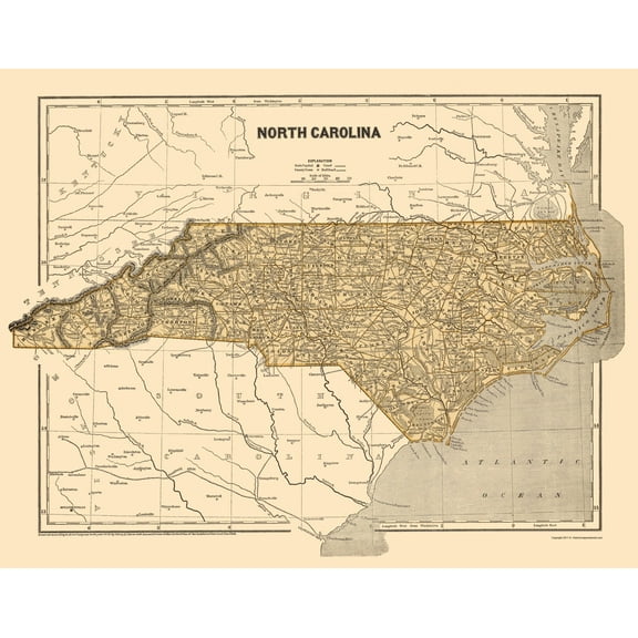
Topographical Map - Florida Alabama Fort Barrancas Quad - USGS 1943 - 23 x 28.92 - Vintage Wall Art $40.95 $40.95/count
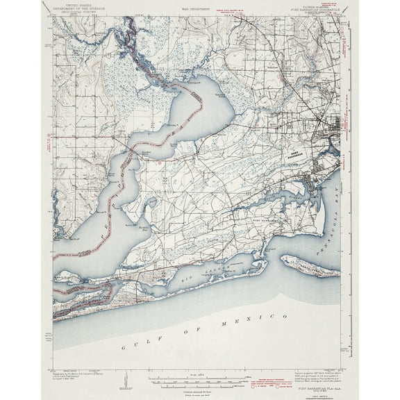 $4095current price $40.95$40.95/count
Topographical Map - Florida Alabama Fort Barrancas Quad - USGS 1943 - 23 x 28.92 - Vintage Wall Art
Topographical Map - Big Trees California Quad - USGS 1901 - Vintage Wall Art $36.95
 4 optionsAvailable in additional 4 options$3695current price $36.95
Topographical Map - Big Trees California Quad - USGS 1901 - Vintage Wall Art
Historic State Map - South Carolina - Rathbun 1893 - 23 x 28.43 - Vintage Wall Art $40.95 $40.95/count
 3 optionsAvailable in additional 3 options$4095current price $40.95$40.95/count
Historic State Map - South Carolina - Rathbun 1893 - 23 x 28.43 - Vintage Wall Art
Topographical Map - Tonopah Nevada Quad - USGS 1908 - 23 x 27.68 - Vintage Wall Art $94.95 $94.95/count
 3 optionsAvailable in additional 3 options$9495current price $94.95$94.95/count
Topographical Map - Tonopah Nevada Quad - USGS 1908 - 23 x 27.68 - Vintage Wall Art
Customer ratings & reviews
0 ratings|0 reviews
This item does not have any reviews yet

Related pages
- Hampshire Map Mountains
- Washington State Rivers Map
- Oregon Map By County
- Oregon Usa Map
- Map Florida County
- Map Of Kentucky Counties
- National Parks Posters
- Central America Travel Books, Maps & Guides
- Northeast United States Travel Books, Maps & Guides
- Ontario Travel Books, Maps & Guides
- General South America Travel Books, Maps & Guides
- Caribbean & West Indies Travel Books, Maps & Guides