Hero image 0 of Historic Map - Britain Central 1715 - Gardiner 1902 - 23 x 28.41 - Vintage Wall Art, 0 of 5
Historic Map - Britain Central 1715 - Gardiner 1902 - 23 x 28.41 - Vintage Wall Art
(No ratings yet)
Historic Map - Britain Central 1715 - Gardiner 1902 - 23 x 28.41 - Vintage Wall ArtHistoric Map Britain Central 1715 Gardiner 1902 23 x 28 41 Vintage Wall ArtHistoric Map Britain Central 1715 Gardiner 1902 23 x 28 41 Vintage Wall ArtHistoric Map Britain Central 1715 Gardiner 1902 23 x 28 41 Vintage Wall Art
Key item features
- OWN A PIECE OF YOUR HOME COUNTRY - Looking for something that reminds you of the country you or your ancestors originate from? Well now you can own a piece of your heritage with a beautiful map of your home country. Maps of the Past has maps for every need!
- INTERNATIONAL MAPS PROVIDE IMPORTANT INFORMATION - International maps not only show you how the different countries, cities, counties, and territories are divided and where the borders can be found, but it also highlights rivers, mountains, and other natural elements of the land. International maps can also show you natural resources and exports of a country.
- ONLY ACCEPT THE BEST PRINT QUALITY FOR YOUR REPRODUCTIONS - There are many printers and print types available on the market, when purchasing a reproduction there is no finer quality reproduction than a reproduction using the Giclee Printing method. Giclee describes the technique or style of printing used, and it is revered as the highest quality printing because of the way it precisely sprays ink onto a surface. Trust nothing less than the best!
- GUARNANTEED TO GET EXACTLY WHAT YOU ORDERED - This map comes exactly to the specification of 23.00 x 28.41 inches/58.42 X 72.16 cm. All of our maps come rolled, wrapped, and shipped in a heavy gauge mailing tube to ensure it arrives intact.
- WHY CHOOSE MAPS OF THE PAST? - Maps of the Past is one of the single largest producers of different types of maps. They legally own the rights to the maps they sell, and provide them to you in clean, clear, and vibrant print. If you are looking for a high quality map print, then look no further than Maps of the Past!
Specs
- Size23.00 x 28.41
- MaterialPaper
- Decor styleVintage
- FramedN
- ShapeRectangle
- Art typePainting
Price when purchased online
Not Available
How do you want your item?
Not available
Check out these related products
Historic Map - Scotland - Thierry 1831 - 23 x 30.06 - Vintage Wall Art $40.95
 3 optionsAvailable in additional 3 options$4095current price $40.95
Historic Map - Scotland - Thierry 1831 - 23 x 30.06 - Vintage Wall Art
Historic County Map - Rappahannock County Virginia - Hotchkiss 1867 - 23 x 28.99 - Vintage Wall Art $40.95
 $4095current price $40.95
Historic County Map - Rappahannock County Virginia - Hotchkiss 1867 - 23 x 28.99 - Vintage Wall Art
Historic County Map - Benton County Indiana - Andreas 1876 - 23 x 28.38 - Vintage Wall Art $40.95 $40.95/count
 3 optionsAvailable in additional 3 options$4095current price $40.95$40.95/count
Historic County Map - Benton County Indiana - Andreas 1876 - 23 x 28.38 - Vintage Wall Art
Topographical Map - Gloucester Massachusetts Quad - USGS 1984 - Vintage Wall Art $36.95
 $3695current price $36.95
Topographical Map - Gloucester Massachusetts Quad - USGS 1984 - Vintage Wall Art
Topographical Map - Clarkville Colorado Quad - USGS 1972 - Vintage Wall Art $36.95
 $3695current price $36.95
Topographical Map - Clarkville Colorado Quad - USGS 1972 - Vintage Wall Art
Historic Map - Scotland - Tanner - 23 x 28.67 - Vintage Wall Art $40.95 $40.95/count
 $4095current price $40.95$40.95/count
Historic Map - Scotland - Tanner - 23 x 28.67 - Vintage Wall Art
Historic County Map - Randolph County Indiana - Andreas 1876 - 23 x 28.56 - Vintage Wall Art $40.95 $40.95/count
 $4095current price $40.95$40.95/count
Historic County Map - Randolph County Indiana - Andreas 1876 - 23 x 28.56 - Vintage Wall Art
Historic Map - Oceania - Appleton 1856 - 23 x 27.58 - Vintage Wall Art $40.95
 $4095current price $40.95
Historic Map - Oceania - Appleton 1856 - 23 x 27.58 - Vintage Wall Art
Historic Panoramic View - Richmond Virginia - Wells 1863 - 30.92 x 23 - Vintage Wall Art $40.95
 $4095current price $40.95
Historic Panoramic View - Richmond Virginia - Wells 1863 - 30.92 x 23 - Vintage Wall Art
Historic City Map - Mayfield Ohio - Cram 1874 - 23 x 25.25 - Vintage Wall Art $40.95
 $4095current price $40.95
Historic City Map - Mayfield Ohio - Cram 1874 - 23 x 25.25 - Vintage Wall Art
Historic State Map - Kansas - Cram 1875 - 29 x 23 - Vintage Wall Art $40.95 $40.95/count
 4 optionsAvailable in additional 4 options$4095current price $40.95$40.95/count
Historic State Map - Kansas - Cram 1875 - 29 x 23 - Vintage Wall Art
Historic County Map - La Crosse County Wisconsin - Snyder 1878 - 23 x 27.31 - Vintage Wall Art $40.95 $40.95/count
 3 optionsAvailable in additional 3 options$4095current price $40.95$40.95/count
Historic County Map - La Crosse County Wisconsin - Snyder 1878 - 23 x 27.31 - Vintage Wall Art
Topographical Map - Barron Creek Colorado Quad USGS 1979 - Vintage Wall Art $36.95
 4 optionsAvailable in additional 4 options$3695current price $36.95
Topographical Map - Barron Creek Colorado Quad USGS 1979 - Vintage Wall Art
Historic County Map - Forest County Pennsylvania - Barnes 1858 - 23 x 27.17 - Vintage Wall Art $40.95
 $4095current price $40.95
Historic County Map - Forest County Pennsylvania - Barnes 1858 - 23 x 27.17 - Vintage Wall Art
Historic Map - France Forrestry - Cortambert 1880 - 30.19 x 23 - Vintage Wall Art $40.95
 $4095current price $40.95
Historic Map - France Forrestry - Cortambert 1880 - 30.19 x 23 - Vintage Wall Art
Historic Map - Scotland 1285 - Gardiner 1902 - 23 x 29.85 - Vintage Wall Art $40.95
 3 optionsAvailable in additional 3 options$4095current price $40.95
Historic Map - Scotland 1285 - Gardiner 1902 - 23 x 29.85 - Vintage Wall Art
Historic Map - Ireland Southern - Bartholomew 1892 - 23 x 30.44 - Vintage Wall Art $40.95
 3 optionsAvailable in additional 3 options$4095current price $40.95
Historic Map - Ireland Southern - Bartholomew 1892 - 23 x 30.44 - Vintage Wall Art
Historic Map - Greece Colonies - Oxford 1828 - 29.20 x 23 - Vintage Wall Art $40.95 $40.95/count
 $4095current price $40.95$40.95/count
Historic Map - Greece Colonies - Oxford 1828 - 29.20 x 23 - Vintage Wall Art
Historic Map - India 1785 - Gardiner 1902 - 23 x 28.97 - Vintage Wall Art $40.95 $40.95/count
 $4095current price $40.95$40.95/count
Historic Map - India 1785 - Gardiner 1902 - 23 x 28.97 - Vintage Wall Art
Historic Map - Madagascar Africa Southeastern - Streit 1913 - 23 x 27.59 - Vintage Wall Art $40.95
 3 optionsAvailable in additional 3 options$4095current price $40.95
Historic Map - Madagascar Africa Southeastern - Streit 1913 - 23 x 27.59 - Vintage Wall Art
About this item
Product details
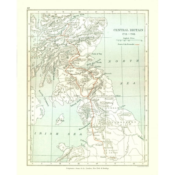
Old International Maps - Central Britain in 1715 - Gardiner 1902 - This is an exquisite full-color Reproduction printed on high-quality gloss paper, art paper or canvas.
Print Size: 23.00 x 28.41 inches
58.42 X 72.16cm
The following towns are featured: Cheadle, Derby, York, Manchester, Wigan, Stockport, Lancaster, Kendal, Appleby, Clifton, Penrth, Durham, Newcastle, Carlisle, Dumfries, Dunbar, Edinburgh, Glasgow, Stirling, Perth, Inverary, Aberdeen, Inverness, Dalwhinnie, Glengarry, Glenfinnan.
This Map is Situated in: Great Britain.
SKU: ITGB0001
Original Maps are often difficult to find and usually have fold lines, identifying stamps or markings, tears, ragged edges, and assorted other natural signs of age that detract from their beauty. All of our maps have been professionally restored to depict their original beauty, while keeping all historical data intact.
These maps are fabulous pieces of history full of information useful to Historians, Genealogists, Cartographers, Relic Hunters, & Others. They make fascinating conversation pieces and splendid works of art for the home or office.
- OWN A PIECE OF YOUR HOME COUNTRY - Looking for something that reminds you of the country you or your ancestors originate from? Well now you can own a piece of your heritage with a beautiful map of your home country. Maps of the Past has maps for every need!
- INTERNATIONAL MAPS PROVIDE IMPORTANT INFORMATION - International maps not only show you how the different countries, cities, counties, and territories are divided and where the borders can be found, but it also highlights rivers, mountains, and other natural elements of the land. International maps can also show you natural resources and exports of a country.
- ONLY ACCEPT THE BEST PRINT QUALITY FOR YOUR REPRODUCTIONS - There are many printers and print types available on the market, when purchasing a reproduction there is no finer quality reproduction than a reproduction using the Giclee Printing method. Giclee describes the technique or style of printing used, and it is revered as the highest quality printing because of the way it precisely sprays ink onto a surface. Trust nothing less than the best!
- GUARNANTEED TO GET EXACTLY WHAT YOU ORDERED - This map comes exactly to the specification of 23.00 x 28.41 inches/58.42 X 72.16 cm. All of our maps come rolled, wrapped, and shipped in a heavy gauge mailing tube to ensure it arrives intact.
- WHY CHOOSE MAPS OF THE PAST? - Maps of the Past is one of the single largest producers of different types of maps. They legally own the rights to the maps they sell, and provide them to you in clean, clear, and vibrant print. If you are looking for a high quality map print, then look no further than Maps of the Past!
info:
We aim to show you accurate product information. Manufacturers, suppliers and others provide what you see here, and we have not verified it.
Specifications
Size
23.00 x 28.41
Material
Paper
Decor style
Vintage
Theme
Historical International Maps
Customer ratings & reviews
0 ratings|0 reviews
This item does not have any reviews yet
