Hero image 0 of Historic County Map - Sullivan County New York - Burr 1829 - 23.75 x 23 - Vintage Wall Art, 0 of 5
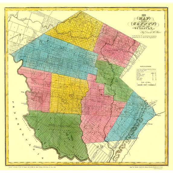
Historic County Map - Sullivan County New York - Burr 1829 - 23.75 x 23 - Vintage Wall Art
(No ratings yet)
Key item features
- HISTORICAL LOCAL MAPS MAKE GREAT WALL ART - Ever wonder what your country looked like during the early days of the USA? Well now you can find out! Maps of the Past provides maps from various time periods so you can track the history of your local city or town. These gorgiously detailed maps make for a great piece of art for your home or office. Own a piece of art and history today!
- LOCAL MAPS PROVIDE IMPORTANT INFORMATION - Local maps show you how the borders of a local are established and were they can be found. It also highlights rivers, mountains, and other natural element you may not know are there. Local maps can also show you transportation lanes across your local
- ONLY ACCEPT THE BEST PRINT QUALITY FOR YOUR REPRODUCTIONS - There are many printers and print types available on the market, when purchasing a reproduction there is no finer quality reproduction than a reproduction using the Giclee Printing method. Giclee describes the technique or style of printing used, and it is revered as the highest quality printing because of the way it precisely sprays ink onto a surface. Trust nothing less than the best!
- GUARNANTEED TO GET EXACTLY WHAT YOU ORDERED - This map comes exactly to the specification of 23.75 x 23.00 inches/60.32 X 58.42 cm. All of our maps come rolled, wrapped, and shipped in a heavy gauge mailing tube to ensure it arrives intact.
- WHY CHOOSE MAPS OF THE PAST? - Maps of the Past is one of the single largest producers of different types of maps. They legally own the rights to the maps they sell, and provide them to you in clean, clear, and vibrant print. If you are looking for a high quality map print, then look no further than Maps of the Past!
Specs
- Size23.75 x 23
- MaterialGlossy Satin Photo Quality
- Decor styleVintage
- ThemeHistorical County Maps
- ShapeRectangle
- Art typePainting
Current price is USD$40.95$40.95/count
Price when purchased online
- Free shipping
 Free 30-day returns
How do you want your item?
Columbus, 43215
Arrives between Apr 11 - Apr 13
|Sold and shipped by Maps of the Past
4.3 stars out of 5, based on 10 seller reviews(4.3)10 seller reviews
Free 30-day returns
About this item
Product details
Old County Map - Sullivan New York Landowner - Burr 1829 - This is an exquisite full-color Reproduction printed on high-quality gloss paper, art paper or canvas.
Print Size: 23.00 x 23.75 inches
60.32 X 58.42cm
Sites and Townships Specific To This Map Are: Mount Hope and Lumberland Turnpike, Delaware and Hudson Canal, Beaver Kill, Round Pond, Willewmac Creek, Lake Superior, Ten Mile River, Delaware River & Some Named Landowners.
The following towns are featured: Cochecton, Thompson, Monticello, Bridgeville, Warrowsburgh & Mount Vernon.
This Map is Situated in: Sullivan County, New York.
SKU: NYSU0002
Original Maps are often difficult to find and usually have fold lines, identifying stamps or markings, tears, ragged edges, and assorted other natural signs of age that detract from their beauty. All of our maps have been professionally restored to depict their original beauty, while keeping all historical data intact.
These maps are fabulous pieces of history full of information useful to Historians, Genealogists, Cartographers, Relic Hunters, & Others. They make fascinating conversation pieces and splendid works of art for the home or office.
- HISTORICAL LOCAL MAPS MAKE GREAT WALL ART - Ever wonder what your country looked like during the early days of the USA? Well now you can find out! Maps of the Past provides maps from various time periods so you can track the history of your local city or town. These gorgiously detailed maps make for a great piece of art for your home or office. Own a piece of art and history today!
- LOCAL MAPS PROVIDE IMPORTANT INFORMATION - Local maps show you how the borders of a local are established and were they can be found. It also highlights rivers, mountains, and other natural element you may not know are there. Local maps can also show you transportation lanes across your local
- ONLY ACCEPT THE BEST PRINT QUALITY FOR YOUR REPRODUCTIONS - There are many printers and print types available on the market, when purchasing a reproduction there is no finer quality reproduction than a reproduction using the Giclee Printing method. Giclee describes the technique or style of printing used, and it is revered as the highest quality printing because of the way it precisely sprays ink onto a surface. Trust nothing less than the best!
- GUARNANTEED TO GET EXACTLY WHAT YOU ORDERED - This map comes exactly to the specification of 23.75 x 23.00 inches/60.32 X 58.42 cm. All of our maps come rolled, wrapped, and shipped in a heavy gauge mailing tube to ensure it arrives intact.
- WHY CHOOSE MAPS OF THE PAST? - Maps of the Past is one of the single largest producers of different types of maps. They legally own the rights to the maps they sell, and provide them to you in clean, clear, and vibrant print. If you are looking for a high quality map print, then look no further than Maps of the Past!
info:
We aim to show you accurate product information. Manufacturers, suppliers and others provide what you see here, and we have not verified it.
Specifications
Size
23.75 x 23
Material
Glossy Satin Photo Quality
Decor style
Vintage
Theme
Historical County Maps
Warranty
Warranty information
Please be aware that the warranty terms on items offered for sale by third party Marketplace sellers may differ from those displayed in this section (if any). To confirm warranty terms on an item offered for sale by a third party Marketplace seller, please use the 'Contact seller' feature on the third party Marketplace seller's information page and request the item's warranty terms prior to purchase.
Similar items you might like
Based on what customers bought
100+ bought since yesterday Home Decor Collection Black Round Wall Art or Tabletop, White Rose Floral Print by Antoine Monnoyer with Gold Beaded Frame, Classic Decorative Artwork, 6x8 $7.83
100+ bought since yesterday $783current price $7.83
Home Decor Collection Black Round Wall Art or Tabletop, White Rose Floral Print by Antoine Monnoyer with Gold Beaded Frame, Classic Decorative Artwork, 6x8
1884.7 out of 5 Stars. 188 reviewsIn 50+ people's carts Beautiful Classic Landscape Wall Art Set of 3, Vintage Framed Wall Décor, Gold Brushed Multi-Size Frames, Farmhouse Landscape Art for Living Room, Office, Entry $18.23
In 50+ people's carts $1823current price $18.23
Beautiful Classic Landscape Wall Art Set of 3, Vintage Framed Wall Décor, Gold Brushed Multi-Size Frames, Farmhouse Landscape Art for Living Room, Office, Entry
1074.5 out of 5 Stars. 107 reviewsHistoric State Map - New Jersey - Burr 1835 - 23 x 28.63 - Vintage Wall Art $40.95 $40.95/count
 3 optionsAvailable in additional 3 options$4095current price $40.95$40.95/count
Historic State Map - New Jersey - Burr 1835 - 23 x 28.63 - Vintage Wall Art
In 50+ people's carts Home Decor Collection Gold Metro Beaded Oval Framed Landscape Wall Art, Vintage-Style Décor for Living Room, Entryway, Bedroom, or Office, 14x11 $7.49
In 50+ people's carts $749current price $7.49
Home Decor Collection Gold Metro Beaded Oval Framed Landscape Wall Art, Vintage-Style Décor for Living Room, Entryway, Bedroom, or Office, 14x11
1774.4 out of 5 Stars. 177 reviewsHistoric State Map - Georgia Alabama - Burr 1839 - 23 x 31.41 - Vintage Wall Art $45.95 $45.95/count
 4 optionsAvailable in additional 4 options$4595current price $45.95$45.95/count
Historic State Map - Georgia Alabama - Burr 1839 - 23 x 31.41 - Vintage Wall Art
Historic State Map - Colorado - Rathbun 1893 - Vintage Wall Art $36.95
 4 optionsAvailable in additional 4 options$3695current price $36.95
Historic State Map - Colorado - Rathbun 1893 - Vintage Wall Art
Historic State Map - New England - Davenport 1883 - 23 x 35.59 - Vintage Wall Art $40.95 $40.95/count
 3 optionsAvailable in additional 3 options$4095current price $40.95$40.95/count
Historic State Map - New England - Davenport 1883 - 23 x 35.59 - Vintage Wall Art
Historic State Map - California - Thompson 1898 - Vintage Wall Art $36.95
 $3695current price $36.95
Historic State Map - California - Thompson 1898 - Vintage Wall Art
Historic State Map - Kentucky - Lloyd 1862 - 30 x 23 - Vintage Wall Art $45.95 $45.95/count
 4 optionsAvailable in additional 4 options$4595current price $45.95$45.95/count
Historic State Map - Kentucky - Lloyd 1862 - 30 x 23 - Vintage Wall Art
Best seller Drsoum Vintage Ocean Seascape Canvas Wall Art Seaside Coastal Scenery Classic Bathroom Office Decor 10x10in Natural Framed $8.99
Best seller


 $899current price $8.99
Drsoum Vintage Ocean Seascape Canvas Wall Art Seaside Coastal Scenery Classic Bathroom Office Decor 10x10in Natural Framed
2414.5 out of 5 Stars. 241 reviewsHistoric County Map - Chittenden County Vermont - Beers 1878 - 23 x 28.25 - Vintage Wall Art $40.95 $40.95/count
 $4095current price $40.95$40.95/count
Historic County Map - Chittenden County Vermont - Beers 1878 - 23 x 28.25 - Vintage Wall Art
Best seller Style House 16"x 20" Contemporary Arch Framed Wall Art $13.90
Best seller 2 optionsAvailable in additional 2 options$1390current price $13.90
Style House 16"x 20" Contemporary Arch Framed Wall Art
1934.7 out of 5 Stars. 193 reviewsHistoric State Map - New Mexico - Rathbun 1893 - 23 x 26.44 - Vintage Wall Art $40.95
 3 optionsAvailable in additional 3 options$4095current price $40.95
Historic State Map - New Mexico - Rathbun 1893 - 23 x 26.44 - Vintage Wall Art
Historic State Map - Missouri - Burr 1835 - Vintage Wall Art $36.95
 $3695current price $36.95
Historic State Map - Missouri - Burr 1835 - Vintage Wall Art
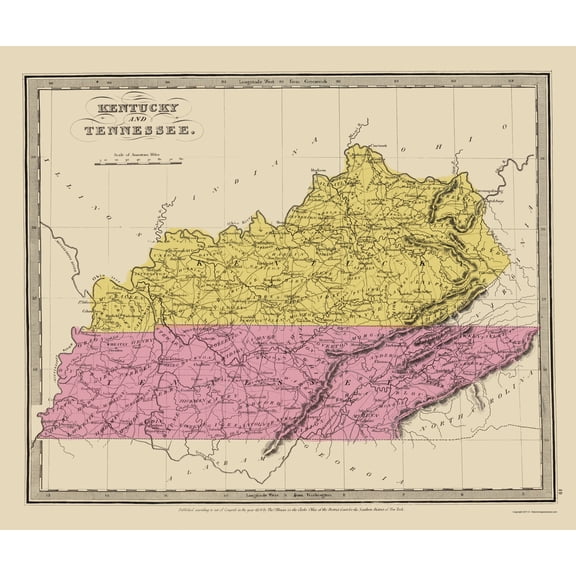
Historic State Map - Kentucky Tennessee - Illman 1834 - 23 x 27.35 - Vintage Wall Art $40.95 $40.95/count
 4 optionsAvailable in additional 4 options$4095current price $40.95$40.95/count
Historic State Map - Kentucky Tennessee - Illman 1834 - 23 x 27.35 - Vintage Wall Art
Historic State Map - Connecticut - Tanner 1834 - Vintage Wall Art $36.95
 $3695current price $36.95
Historic State Map - Connecticut - Tanner 1834 - Vintage Wall Art
Historic State Map - Massachusetts Region - 1776 - Vintage Wall Art $36.95
 $3695current price $36.95
Historic State Map - Massachusetts Region - 1776 - Vintage Wall Art
Historic County Map - Sacramento County California - Phinney 1911 - Vintage Wall Art $36.95
 $3695current price $36.95
Historic County Map - Sacramento County California - Phinney 1911 - Vintage Wall Art
Historic State Map - Arizona Territory R.P. Kelley - Schrader 1860 - Vintage Wall Art $36.95
 $3695current price $36.95
Historic State Map - Arizona Territory R.P. Kelley - Schrader 1860 - Vintage Wall Art
Historic State Map - Florida - Lucas 1823 - 23 x 28.06 - Vintage Wall Art $45.95
 4 optionsAvailable in additional 4 options$4595current price $45.95
Historic State Map - Florida - Lucas 1823 - 23 x 28.06 - Vintage Wall Art
Customer ratings & reviews
0 ratings|0 reviews
This item does not have any reviews yet

Related pages
- Council Bluffs Iowa Map
- Northampton County Pa Map
- Kentucky Counties Map
- Akron Ohio Map
- Cincinnati Landmarks
- Council Bluffs Map
- Central America Travel Books, Maps & Guides
- National Parks Posters
- Midwest United States Travel Books, Maps & Guides
- Northeast United States Travel Books, Maps & Guides
- Western United States Travel Books, Maps & Guides
- General South America Travel Books, Maps & Guides