Hero image 0 of Historic County Map - Shawnee County Kansas - Everts 1887 - Vintage Wall Art, 0 of 4
Historic County Map - Shawnee County Kansas - Everts 1887 - Vintage Wall Art
(No ratings yet)
Historic County Map - Shawnee County Kansas - Everts 1887 - Vintage Wall ArtHistoric County Map Shawnee County Kansas Everts 1887 23 x 28 09 Vintage Wall ArtHistoric County Map Shawnee County Kansas Everts 1887 Vintage Wall ArtHistoric County Map Shawnee County Kansas Everts 1887 23 x 28 09 Vintage Wall ArtHistoric County Map Shawnee County Kansas Everts 1887 Vintage Wall Art
Material:Glossy Photo
Size:23.00 x 28.09
Key item features
- HISTORICAL LOCAL MAPS MAKE GREAT WALL ART - Ever wonder what your country looked like during the early days of the USA? Well now you can find out! Maps of the Past provides maps from various time periods so you can track the history of your local city or town. These gorgiously detailed maps make for a great piece of art for your home or office. Own a piece of art and history today!
- LOCAL MAPS PROVIDE IMPORTANT INFORMATION - Local maps show you how the borders of a local are established and were they can be found. It also highlights rivers, mountains, and other natural element you may not know are there. Local maps can also show you transportation lanes across your local
- ONLY ACCEPT THE BEST PRINT QUALITY FOR YOUR REPRODUCTIONS - There are many printers and print types available on the market, when purchasing a reproduction there is no finer quality reproduction than a reproduction using the Giclee Printing method. Giclee describes the technique or style of printing used, and it is revered as the highest quality printing because of the way it precisely sprays ink onto a surface. Trust nothing less than the best!
- GUARANTEED TO GET EXACTLY WHAT YOU ORDERED - All of our maps come rolled, wrapped, and shipped in a heavy gauge mailing tube to ensure it arrives intact.
- WHY CHOOSE MAPS OF THE PAST? - Maps of the Past is one of the single largest producers of different types of maps. They legally own the rights to the maps they sell, and provide them to you in clean, clear, and vibrant print. If you are looking for a high quality map print, then look no further than Maps of the Past!
Specs
- ColorMulticolor
- Decor styleIndustrial
- ThemeHistorical County Maps
- FramedN
- ShapeRectangle
- Art typePhotography
Current price is USD$40.95$40.95/count
Price when purchased online
- Free shipping
 Free 30-day returns
How do you want your item?
Columbus, 43215
Arrives between Apr 11 - Apr 13
|Sold and shipped by Maps of the Past
4.3 stars out of 5, based on 10 seller reviews(4.3)10 seller reviews
Free 30-day returns
About this item
Product details
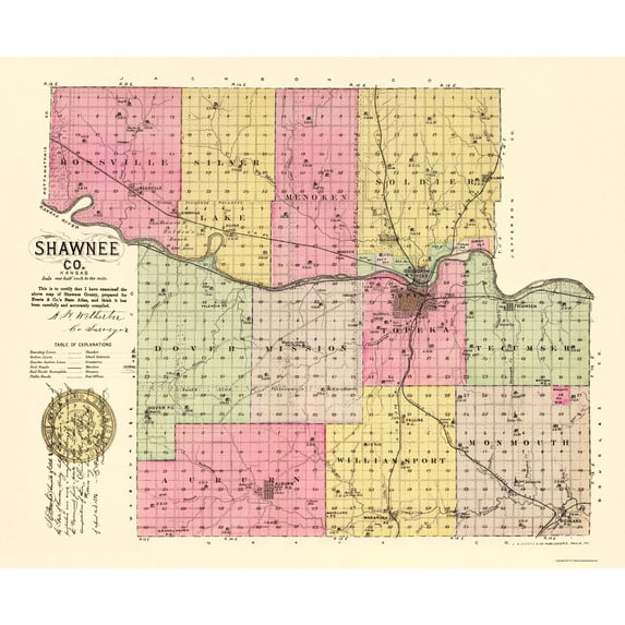
Old County Map - Shawnee Kansas - Everts 1887 - This is an exquisite full-color Reproduction printed on gloss paper or art paper.
Sites and Townships Specific To This Map Are: Rossville, Kingsville, Silver Lake, Kilmer, Indianola, Menoken, Topeka, North Topeka, Tecumseh, Auburn, Wakarusa, and others.
The following towns are featured: townships include Auburn, Dover, Grove, Menoken, Mission, Monmouth, Rossville, Silver Lake, Soldier, Tecumseh, Topeka, and Williamsport. Waterways include the Kansas River and smaller creeks. Rail lines include A T & S Fe Ry, Kansas & Nebraska & Dakota RR, and others.
This Map is Situated in: State of Kansas (KS).
SKU: KSSH0004
Original Maps are often difficult to find and usually have fold lines, identifying stamps or markings, tears, ragged edges, and assorted other natural signs of age that detract from their beauty. All of our maps have been professionally restored to depict their original beauty, while keeping all historical data intact.
These maps are fabulous pieces of history full of information useful to Historians, Genealogists, Cartographers, Relic Hunters, & Others. They make fascinating conversation pieces and splendid works of art for the home or office.
- HISTORICAL LOCAL MAPS MAKE GREAT WALL ART - Ever wonder what your country looked like during the early days of the USA? Well now you can find out! Maps of the Past provides maps from various time periods so you can track the history of your local city or town. These gorgiously detailed maps make for a great piece of art for your home or office. Own a piece of art and history today!
- LOCAL MAPS PROVIDE IMPORTANT INFORMATION - Local maps show you how the borders of a local are established and were they can be found. It also highlights rivers, mountains, and other natural element you may not know are there. Local maps can also show you transportation lanes across your local
- ONLY ACCEPT THE BEST PRINT QUALITY FOR YOUR REPRODUCTIONS - There are many printers and print types available on the market, when purchasing a reproduction there is no finer quality reproduction than a reproduction using the Giclee Printing method. Giclee describes the technique or style of printing used, and it is revered as the highest quality printing because of the way it precisely sprays ink onto a surface. Trust nothing less than the best!
- GUARANTEED TO GET EXACTLY WHAT YOU ORDERED - All of our maps come rolled, wrapped, and shipped in a heavy gauge mailing tube to ensure it arrives intact.
- WHY CHOOSE MAPS OF THE PAST? - Maps of the Past is one of the single largest producers of different types of maps. They legally own the rights to the maps they sell, and provide them to you in clean, clear, and vibrant print. If you are looking for a high quality map print, then look no further than Maps of the Past!
info:
We aim to show you accurate product information. Manufacturers, suppliers and others provide what you see here, and we have not verified it.
Specifications
Color
Multicolor
Decor style
Industrial
Theme
Historical County Maps
Framed
N
Warranty
Warranty information
Please be aware that the warranty terms on items offered for sale by third party Marketplace sellers may differ from those displayed in this section (if any). To confirm warranty terms on an item offered for sale by a third party Marketplace seller, please use the 'Contact seller' feature on the third party Marketplace seller's information page and request the item's warranty terms prior to purchase.
Similar items you might like
Based on what customers bought
In 50+ people's carts Beautiful Classic Landscape Wall Art Set of 3, Vintage Framed Wall Décor, Gold Brushed Multi-Size Frames, Farmhouse Landscape Art for Living Room, Office, Entry $18.23
In 50+ people's carts $1823current price $18.23
Beautiful Classic Landscape Wall Art Set of 3, Vintage Framed Wall Décor, Gold Brushed Multi-Size Frames, Farmhouse Landscape Art for Living Room, Office, Entry
1074.5 out of 5 Stars. 107 reviewsHistoric County Map - Dallas County Texas - Street 1902 - 23 x 25.52 - Vintage Wall Art $40.95 $40.95/count
 3 optionsAvailable in additional 3 options$4095current price $40.95$40.95/count
Historic County Map - Dallas County Texas - Street 1902 - 23 x 25.52 - Vintage Wall Art
Best seller SHENIFY Black Boho Wall Art Geometric Decor Bedroom Prints Ready To Hang for Bedroom 12x16in3pcs Black Framed $23.97
Best seller


 $2397current price $23.97
SHENIFY Black Boho Wall Art Geometric Decor Bedroom Prints Ready To Hang for Bedroom 12x16in3pcs Black Framed
1254.5 out of 5 Stars. 125 reviewsBest seller Style House 16"x 20" Contemporary Arch Framed Wall Art $13.90
Best seller 2 optionsAvailable in additional 2 options$1390current price $13.90
Style House 16"x 20" Contemporary Arch Framed Wall Art
1934.7 out of 5 Stars. 193 reviewsHistoric County Map - Laurens County South Carolina - Mills 1825 - 28.13 x 23 - Vintage Wall Art $40.95 $40.95/count
 3 optionsAvailable in additional 3 options$4095current price $40.95$40.95/count
Historic County Map - Laurens County South Carolina - Mills 1825 - 28.13 x 23 - Vintage Wall Art
Historic County Map - Stanislaus County California - Stanislaus 1906 - Vintage Wall Art $36.95
 $3695current price $36.95
Historic County Map - Stanislaus County California - Stanislaus 1906 - Vintage Wall Art
Historic County Map - Calhoun County Michigan - Walling 1873 - Vintage Wall Art $36.95
 4 optionsAvailable in additional 4 options$3695current price $36.95
Historic County Map - Calhoun County Michigan - Walling 1873 - Vintage Wall Art
Historic County Map - Catawba County North Carolina - Yoder 1886 - 23 x 39.03 - Vintage Wall Art $40.95 $40.95/count
 3 optionsAvailable in additional 3 options$4095current price $40.95$40.95/count
Historic County Map - Catawba County North Carolina - Yoder 1886 - 23 x 39.03 - Vintage Wall Art
Historic County Map - Kent County Maryland - Martenet 1860 - 23 x 28.13 - Vintage Wall Art $45.95 Was $74.95 $45.95/count
 4 optionsAvailable in additional 4 options$4595current price $45.95, Was $74.95$74.95$45.95/count
Historic County Map - Kent County Maryland - Martenet 1860 - 23 x 28.13 - Vintage Wall Art
Historic County Map - Peoria County Illinois - Warner 1876 - 23 x 28.96 - Vintage Wall Art $40.95
 3 optionsAvailable in additional 3 options$4095current price $40.95
Historic County Map - Peoria County Illinois - Warner 1876 - 23 x 28.96 - Vintage Wall Art
Historic County Map - Dade County Florida Road - Richeson 1921 - Vintage Wall Art $36.95
 $3695current price $36.95
Historic County Map - Dade County Florida Road - Richeson 1921 - Vintage Wall Art
Historic County Map - Brown County Indiana - Andreas 1876 - 23 x 28.25 - Vintage Wall Art $40.95 $40.95/count
 3 optionsAvailable in additional 3 options$4095current price $40.95$40.95/count
Historic County Map - Brown County Indiana - Andreas 1876 - 23 x 28.25 - Vintage Wall Art
Historic County Map - Kankakee County Illinois - Warner 1876 - 23 x 27.44 - Vintage Wall Art $40.95 $40.95/count
 3 optionsAvailable in additional 3 options$4095current price $40.95$40.95/count
Historic County Map - Kankakee County Illinois - Warner 1876 - 23 x 27.44 - Vintage Wall Art
Historic County Map - Delaware Counties Indiana - Andreas 1876 - 23 x 28.75 - Vintage Wall Art $40.95 $40.95/count
 3 optionsAvailable in additional 3 options$4095current price $40.95$40.95/count
Historic County Map - Delaware Counties Indiana - Andreas 1876 - 23 x 28.75 - Vintage Wall Art
Historic County Map - Walworth County Wisconsin - Snyder 1878 - 23 x 28.38 - Vintage Wall Art $40.95 $40.95/count
 3 optionsAvailable in additional 3 options$4095current price $40.95$40.95/count
Historic County Map - Walworth County Wisconsin - Snyder 1878 - 23 x 28.38 - Vintage Wall Art
Historic County Map - Van Zandt County Texas - Highway Department 1936 - 23 x 31.60 - Vintage Wall Art $40.95 $40.95/count
 3 optionsAvailable in additional 3 options$4095current price $40.95$40.95/count
Historic County Map - Van Zandt County Texas - Highway Department 1936 - 23 x 31.60 - Vintage Wall Art
Historic County Map - York County South Carolina - Mills 1825 - 31 x 23 - Vintage Wall Art $40.95 $40.95/count
 3 optionsAvailable in additional 3 options$4095current price $40.95$40.95/count
Historic County Map - York County South Carolina - Mills 1825 - 31 x 23 - Vintage Wall Art
Historic County Map - Collin County Texas - Gast 1881 - 23 x 26.81 - Vintage Wall Art $40.95 $40.95/count
 3 optionsAvailable in additional 3 options$4095current price $40.95$40.95/count
Historic County Map - Collin County Texas - Gast 1881 - 23 x 26.81 - Vintage Wall Art
Historic County Map - Salem County Michigan - Everts 1874 - 23 x 25.72 - Vintage Wall Art $40.95
 4 optionsAvailable in additional 4 options$4095current price $40.95
Historic County Map - Salem County Michigan - Everts 1874 - 23 x 25.72 - Vintage Wall Art
Historic County Map - St Clair County Illinois - Warner 1876 - 23 x 29.56 - Vintage Wall Art $40.95
 3 optionsAvailable in additional 3 options$4095current price $40.95
Historic County Map - St Clair County Illinois - Warner 1876 - 23 x 29.56 - Vintage Wall Art
Customer ratings & reviews
0 ratings|0 reviews
This item does not have any reviews yet

Related pages
- Aerial Ireland
- Tripoli Libya
- Erie Lackawanna Hoboken Terminal
- Europe Brunswick History
- Golden Gate International Exposition 1939 Souvenirs
- San Marino California
- National Parks Posters
- Central America Travel Books, Maps & Guides
- France Travel Books
- Travel Enthusiast
- Eastern Europe Travel Books
- Cyprus Travel Books