Hero image 0 of Historic City Map - Berlin Plymouth Wisconsin - Snyder 1878 - 28.06 x 23 - Vintage Wall Art, 0 of 5
Historic City Map - Berlin Plymouth Wisconsin - Snyder 1878 - 28.06 x 23 - Vintage Wall Art
(No ratings yet)
Historic City Map - Berlin Plymouth Wisconsin - Snyder 1878 - 28.06 x 23 - Vintage Wall ArtHistoric City Map Berlin Plymouth Wisconsin Snyder 1878 28 06 x 23 Vintage Wall ArtHistoric City Map Berlin Plymouth Wisconsin Snyder 1878 28 06 x 23 Vintage Wall ArtHistoric City Map Berlin Plymouth Wisconsin Snyder 1878 28 06 x 23 Vintage Wall Art
Key item features
- HISTORICAL LOCAL MAPS MAKE GREAT WALL ART - Ever wonder what your country looked like during the early days of the USA? Well now you can find out! Maps of the Past provides maps from various time periods so you can track the history of your local city or town. These gorgiously detailed maps make for a great piece of art for your home or office. Own a piece of art and history today!
- LOCAL MAPS PROVIDE IMPORTANT INFORMATION - Local maps show you how the borders of a local are established and were they can be found. It also highlights rivers, mountains, and other natural element you may not know are there. Local maps can also show you transportation lanes across your local
- ONLY ACCEPT THE BEST PRINT QUALITY FOR YOUR REPRODUCTIONS - There are many printers and print types available on the market, when purchasing a reproduction there is no finer quality reproduction than a reproduction using the Giclee Printing method. Giclee describes the technique or style of printing used, and it is revered as the highest quality printing because of the way it precisely sprays ink onto a surface. Trust nothing less than the best!
- GUARNANTEED TO GET EXACTLY WHAT YOU ORDERED - This map comes exactly to the specification of 28.06 x 23.00 inches/71.27 X 58.42 cm. All of our maps come rolled, wrapped, and shipped in a heavy gauge mailing tube to ensure it arrives intact.
- WHY CHOOSE MAPS OF THE PAST? - Maps of the Past is one of the single largest producers of different types of maps. They legally own the rights to the maps they sell, and provide them to you in clean, clear, and vibrant print. If you are looking for a high quality map print, then look no further than Maps of the Past!
Specs
- Size28.06 x 23
- MaterialMatte Bright Canvas
- Decor styleVintage
- ThemeHistorical City Maps
- ShapeRectangle
- Rec. roomOffice
Price when purchased online
Not Available
How do you want your item?
Not available
Check out these related products
Historic County Map - Waukesha County Wisconsin - Snyder 1878 - 23 x 28 - Vintage Wall Art $40.95 $40.95/count
 $4095current price $40.95$40.95/count
Historic County Map - Waukesha County Wisconsin - Snyder 1878 - 23 x 28 - Vintage Wall Art
Railroad Map - Wyoming Railroads Townships - Cram 1875 - 29.06 x 23 - Vintage Wall Art $40.95
 3 optionsAvailable in additional 3 options$4095current price $40.95
Railroad Map - Wyoming Railroads Townships - Cram 1875 - 29.06 x 23 - Vintage Wall Art
Historic County Map - Walworth County Wisconsin - Snyder 1878 - 23 x 28.38 - Vintage Wall Art $40.95 $40.95/count
 $4095current price $40.95$40.95/count
Historic County Map - Walworth County Wisconsin - Snyder 1878 - 23 x 28.38 - Vintage Wall Art
Historic Panoramic View - Champaign Illinois - Ruger 1869 - 23 x 29.37 - Vintage Wall Art $40.95
 $4095current price $40.95
Historic Panoramic View - Champaign Illinois - Ruger 1869 - 23 x 29.37 - Vintage Wall Art
Historic City Map - Los Angeles California Street Index - Hill 1928 - Vintage Wall Art $36.95
 $3695current price $36.95
Historic City Map - Los Angeles California Street Index - Hill 1928 - Vintage Wall Art
Historic County Map - Eau Claire County Wisconsin - Snyder 1878 - 23 x 28.06 - Vintage Wall Art $40.95 $40.95/count
 $4095current price $40.95$40.95/count
Historic County Map - Eau Claire County Wisconsin - Snyder 1878 - 23 x 28.06 - Vintage Wall Art
Historic State Map - Colorado Territory - Richards 1873 - Vintage Wall Art $36.95
 $3695current price $36.95
Historic State Map - Colorado Territory - Richards 1873 - Vintage Wall Art
Historic County Map - Racine Kenosha Counties Wisconsin - Snyder 1878 - 23 x 28.94 - Vintage Wall Art $40.95
 $4095current price $40.95
Historic County Map - Racine Kenosha Counties Wisconsin - Snyder 1878 - 23 x 28.94 - Vintage Wall Art
Historic City Map - Arlington Texas - Ashburn 1960 - 23 x 38.66 - Vintage Wall Art $40.95
 $4095current price $40.95
Historic City Map - Arlington Texas - Ashburn 1960 - 23 x 38.66 - Vintage Wall Art
Historic State Map - Arizona - Asher 1874 - Vintage Wall Art $36.95
 $3695current price $36.95
Historic State Map - Arizona - Asher 1874 - Vintage Wall Art
Historic City Map - Bedford Ohio - Titus 1874 - 23 x 25.13 - Vintage Wall Art $40.95
 $4095current price $40.95
Historic City Map - Bedford Ohio - Titus 1874 - 23 x 25.13 - Vintage Wall Art
Historic State Map - Texas - Colton 1856 - 28 x 23 - Vintage Wall Art $40.95
 $4095current price $40.95
Historic State Map - Texas - Colton 1856 - 28 x 23 - Vintage Wall Art
Historic State Map - Kentucky - Smith 1795 - Vintage Wall Art $36.95
 $3695current price $36.95
Historic State Map - Kentucky - Smith 1795 - Vintage Wall Art
Historic State Map - North Carolina - Tanner 1833 - 28.13 x 23 - Vintage Wall Art $40.95 $40.95/count
 $4095current price $40.95$40.95/count
Historic State Map - North Carolina - Tanner 1833 - 28.13 x 23 - Vintage Wall Art
Historic State Map - Nebraska - Asher 1874 - 23 x 33.37 - Vintage Wall Art $40.95
 $4095current price $40.95
Historic State Map - Nebraska - Asher 1874 - 23 x 33.37 - Vintage Wall Art
Historic City Map - Haywards California - Boardman 1878 - Vintage Wall Art $36.95
 4 optionsAvailable in additional 4 options$3695current price $36.95
Historic City Map - Haywards California - Boardman 1878 - Vintage Wall Art
Historic County Map - Jefferson County Wisconsin - Snyder 1878 - 23 x 28 - Vintage Wall Art $40.95 $40.95/count
 3 optionsAvailable in additional 3 options$4095current price $40.95$40.95/count
Historic County Map - Jefferson County Wisconsin - Snyder 1878 - 23 x 28 - Vintage Wall Art
Historic State Map - Arkansas - Colton 1855 - Vintage Wall Art $36.95
 4 optionsAvailable in additional 4 options$3695current price $36.95
Historic State Map - Arkansas - Colton 1855 - Vintage Wall Art
Historic City Map - Danvers Massachusetts County - Friend 1852 - Vintage Wall Art $36.95
 $3695current price $36.95
Historic City Map - Danvers Massachusetts County - Friend 1852 - Vintage Wall Art
Historic State Map - Texas Settlement Grants - Tanner 1836 - 23 x 28.57 - Vintage Wall Art $40.95 $40.95/count
 $4095current price $40.95$40.95/count
Historic State Map - Texas Settlement Grants - Tanner 1836 - 23 x 28.57 - Vintage Wall Art
About this item
Product details
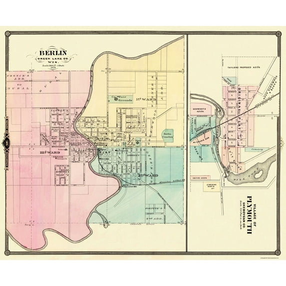
Old City Map - Berlin, Plymouth Wisconsin - 1878 - This is an exquisite full-color Reproduction printed on high-quality gloss paper, art paper or canvas.
Print Size: 23.00 x 28.09 inches
71.27 X 58.42cm
Sites and Townships Specific To This Map Are: Berlin and Plymouth
The following towns are featured: City plans of Berlin and Plymouth with street names and plots (some numbered). Features of Berlin include wards 1-3, original plat, County Fair Grounds, Cemetery, Chicago Milwaukee and St. Paul Railroad, Stave and Saw Mill, Grist Mills, Woolen Mill, Episcopal Church, Union Church, Baptist Church, Catholic Church, German Church, Depot, Public Square, Additions, School and the Fox River. Features of Plymouth include Mill Pond, Mullet River, Flour Mill, Additions, Proposed Additions, Subdivisions, Hub Factory, Saw Mill, Planning Mill, Depot, Park, Original Plat, cemetery, Sheb. & Fond du Lac Railroad and Mil. & Nothn Railroad.
This Map is Situated in: Green Lake and Sheboygen County, Wisconsin (WI)
SKU: WIBE0003
Original Maps are often difficult to find and usually have fold lines, identifying stamps or markings, tears, ragged edges, and assorted other natural signs of age that detract from their beauty. All of our maps have been professionally restored to depict their original beauty, while keeping all historical data intact.
These maps are fabulous pieces of history full of information useful to Historians, Genealogists, Cartographers, Relic Hunters, & Others. They make fascinating conversation pieces and splendid works of art for the home or office.
- HISTORICAL LOCAL MAPS MAKE GREAT WALL ART - Ever wonder what your country looked like during the early days of the USA? Well now you can find out! Maps of the Past provides maps from various time periods so you can track the history of your local city or town. These gorgiously detailed maps make for a great piece of art for your home or office. Own a piece of art and history today!
- LOCAL MAPS PROVIDE IMPORTANT INFORMATION - Local maps show you how the borders of a local are established and were they can be found. It also highlights rivers, mountains, and other natural element you may not know are there. Local maps can also show you transportation lanes across your local
- ONLY ACCEPT THE BEST PRINT QUALITY FOR YOUR REPRODUCTIONS - There are many printers and print types available on the market, when purchasing a reproduction there is no finer quality reproduction than a reproduction using the Giclee Printing method. Giclee describes the technique or style of printing used, and it is revered as the highest quality printing because of the way it precisely sprays ink onto a surface. Trust nothing less than the best!
- GUARNANTEED TO GET EXACTLY WHAT YOU ORDERED - This map comes exactly to the specification of 28.06 x 23.00 inches/71.27 X 58.42 cm. All of our maps come rolled, wrapped, and shipped in a heavy gauge mailing tube to ensure it arrives intact.
- WHY CHOOSE MAPS OF THE PAST? - Maps of the Past is one of the single largest producers of different types of maps. They legally own the rights to the maps they sell, and provide them to you in clean, clear, and vibrant print. If you are looking for a high quality map print, then look no further than Maps of the Past!
info:
We aim to show you accurate product information. Manufacturers, suppliers and others provide what you see here, and we have not verified it.
Specifications
Size
28.06 x 23
Material
Matte Bright Canvas
Decor style
Vintage
Theme
Historical City Maps
Customer ratings & reviews
0 ratings|0 reviews
This item does not have any reviews yet

Related pages
- Des Moines Ia Airport
- 1933 Chicago World Fair Souvenirs
- 10202 E Washington St Indianapolis 46229
- Midway Chicago Airport
- North Slope Borough Fire Department
- San Marino California
- National Parks Posters
- Central America Travel Books, Maps & Guides
- Midwest United States Travel Books, Maps & Guides
- Western United States Travel Books, Maps & Guides
- General South America Travel Books, Maps & Guides
- Northeast United States Travel Books, Maps & Guides