Hero image 0 of Historic State Map - Washington Territory East Cascade Mountains - Bien 1862 - 23 x 30 - Vintage Wall Art, 0 of 5
Historic State Map - Washington Territory East Cascade Mountains - Bien 1862 - 23 x 30 - Vintage Wall Art
(No ratings yet)
Historic State Map - Washington Territory East Cascade Mountains - Bien 1862 - 23 x 30 - Vintage Wall ArtHistoric State Map Washington Territory East Cascade Mountains Bien 1862 23 x 30 Vintage Wall ArtHistoric State Map Washington Territory East Cascade Mountains Bien 1862 23 x 30 Vintage Wall Art
Material:Glossy Satin Photo Quality
Key item features
- OWN A STATE MAP TODAY - If you are looking for a map of your state, or another specific state, to frame and hang on your wall, then look no further! Our state maps are also great for school projects. Our maps have a variety of uses, and they come in a variety of styles. We have every state map you could need!
- STATE MAPS PROVIDE IMPORTANT INFORMATION - State maps not only show you how the different counties and/or cities are divided up and where the borders can be found within a state, but it also highlights rivers, mountains, and other natural elements. Some of them may also provide
- ONLY ACCEPT THE BEST PRINT QUALITY FOR YOUR REPRODUCTIONS - There are many printers and print types available on the market, when purchasing a reproduction there is no finer quality reproduction than a reproduction using the Giclee Printing method. Giclee describes the technique or style of printing used, and it is revered as the highest quality printing because of the way it precisely sprays ink onto a surface. Trust nothing less than the best!
- GUARNANTEED TO GET EXACTLY WHAT YOU ORDERED - This map comes exactly to the specification of 23.00 x 30.44 inches/58.42 X 77.31 cm. All of our maps come rolled, wrapped, and shipped in a heavy gauge mailing tube to ensure it arrives intact.
- WHY CHOOSE MAPS OF THE PAST? - Maps of the Past is one of the single largest producers of different types of maps. They legally own the rights to the maps they sell, and provide them to you in clean, clear, and vibrant print. If you are looking for a high quality map print, then look no further than Maps of the Past!
Specs
- Size23.00 x 30.44
- MaterialGlossy Satin Photo Quality
- Decor styleVintage
- ThemeOld State Maps
- ShapeRectangle
- Rec. roomOffice
Current price is USD$40.95
Price when purchased online
- Free shipping
 Free 30-day returns
How do you want your item?
Columbus, 43215
Arrives between Feb 28 - Mar 3
|Sold and shipped by Maps of the Past
4.3 stars out of 5, based on 10 seller reviews(4.3)10 seller reviews
Free 30-day returns
Check out these related products
Topographical Map - Colorado Rocky Mountains Wyoming - King 1876 - 23 x 34.58 - Vintage Wall Art $40.95
 $4095current price $40.95
Topographical Map - Colorado Rocky Mountains Wyoming - King 1876 - 23 x 34.58 - Vintage Wall Art
Historic State Map - Michigan Saginaw Mackinac Road Survey - Poole 1835 - 23 x 41 - Vintage Wall Art $40.95 $40.95/count
 $4095current price $40.95$40.95/count
Historic State Map - Michigan Saginaw Mackinac Road Survey - Poole 1835 - 23 x 41 - Vintage Wall Art
Historic City Map - Decorah Northwood Charles City Iowa - Andreas 1874 - 23 x 27.61 - Vintage Wall Art $40.95
 $4095current price $40.95
Historic City Map - Decorah Northwood Charles City Iowa - Andreas 1874 - 23 x 27.61 - Vintage Wall Art
Historic City Map - Houston Texas Street Guide - Kelsen 1913 - 26.44 x 23 - Vintage Wall Art $40.95
 $4095current price $40.95
Historic City Map - Houston Texas Street Guide - Kelsen 1913 - 26.44 x 23 - Vintage Wall Art
Historic Map - Ancient Italy - Mitchell 1844 - 23 x 27.87 - Vintage Wall Art $40.95 $40.95/count
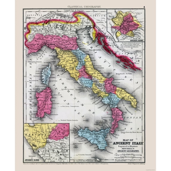 3 optionsAvailable in additional 3 options$4095current price $40.95$40.95/count
Historic Map - Ancient Italy - Mitchell 1844 - 23 x 27.87 - Vintage Wall Art
Historic State Map - Oregon Upper California - Weber 1848 - 23 x 28.62 - Vintage Wall Art $40.95
 $4095current price $40.95
Historic State Map - Oregon Upper California - Weber 1848 - 23 x 28.62 - Vintage Wall Art
Historical Civil War Map - Virginia Eastern Portion - Preston 1864 - 23 x 39.12 - Vintage Wall Art $40.95
 $4095current price $40.95
Historical Civil War Map - Virginia Eastern Portion - Preston 1864 - 23 x 39.12 - Vintage Wall Art
Historic Mine Map - California Tertiary Auriferous Gravel Deposits - Hoffmann 1873 - 23 x 25 - Vintage Wall Art $40.95 $40.95/count
 3 optionsAvailable in additional 3 options$4095current price $40.95$40.95/count
Historic Mine Map - California Tertiary Auriferous Gravel Deposits - Hoffmann 1873 - 23 x 25 - Vintage Wall Art
Historic Nautical Map - Truckee River System - Newlands 1890 - 27.19 x 23 - Vintage Wall Art $40.95
 $4095current price $40.95
Historic Nautical Map - Truckee River System - Newlands 1890 - 27.19 x 23 - Vintage Wall Art
Historic County Map - Philadelphia County Pennsylvania - Walling 1872 - 23 x 28.19 - Vintage Wall Art $40.95 $40.95/count
 3 optionsAvailable in additional 3 options$4095current price $40.95$40.95/count
Historic County Map - Philadelphia County Pennsylvania - Walling 1872 - 23 x 28.19 - Vintage Wall Art
Railroad Map - Vermont Railroads - Coffins 1896 - 23 x 29.89 - Vintage Wall Art $40.95 $40.95/count
 3 optionsAvailable in additional 3 options$4095current price $40.95$40.95/count
Railroad Map - Vermont Railroads - Coffins 1896 - 23 x 29.89 - Vintage Wall Art
Historic Nautical Map - Rio Grande - 1878 - 23 x 26.04 - Vintage Wall Art $40.95
 3 optionsAvailable in additional 3 options$4095current price $40.95
Historic Nautical Map - Rio Grande - 1878 - 23 x 26.04 - Vintage Wall Art
Historic County Map - Bay County Michigan - Walling 1873 - 23 x 29 - Vintage Wall Art $40.95
 3 optionsAvailable in additional 3 options$4095current price $40.95
Historic County Map - Bay County Michigan - Walling 1873 - 23 x 29 - Vintage Wall Art
Historic City Map - Mount Desert Island Maine - Rand McNally 1893 - 23 x 28.13 - Vintage Wall Art $40.95 $40.95/count
 $4095current price $40.95$40.95/count
Historic City Map - Mount Desert Island Maine - Rand McNally 1893 - 23 x 28.13 - Vintage Wall Art
Railroad Map - South Western Virginia - Nader 1892 - 35.70 x 23 - Vintage Wall Art $40.95
 $4095current price $40.95
Railroad Map - South Western Virginia - Nader 1892 - 35.70 x 23 - Vintage Wall Art
Railroad Map - Washington Land Grant Problems - 1883 - 23 x 34 - Vintage Wall Art $40.95 $40.95/count
 $4095current price $40.95$40.95/count
Railroad Map - Washington Land Grant Problems - 1883 - 23 x 34 - Vintage Wall Art
Historic Nautical Map - Ohio River - Collot 1796 - 23 x 32.91 - Vintage Wall Art $40.95 $40.95/count
 $4095current price $40.95$40.95/count
Historic Nautical Map - Ohio River - Collot 1796 - 23 x 32.91 - Vintage Wall Art
Historic State Map - Texas Surrounding Territories - Radefeld 1846 - 23 x 27.42 - Vintage Wall Art $40.95 $40.95/count
 $4095current price $40.95$40.95/count
Historic State Map - Texas Surrounding Territories - Radefeld 1846 - 23 x 27.42 - Vintage Wall Art
Historic County Map - Kent County Michigan - Walling 1873 - 23 x 30 - Vintage Wall Art $40.95 $40.95/count
 3 optionsAvailable in additional 3 options$4095current price $40.95$40.95/count
Historic County Map - Kent County Michigan - Walling 1873 - 23 x 30 - Vintage Wall Art
Historic Map - Cape Breton Nova Scotia - Jeffreys 1755 - 23 x 31 - Vintage Wall Art $40.95
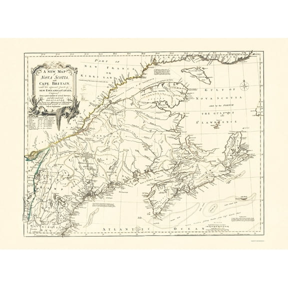 3 optionsAvailable in additional 3 options$4095current price $40.95
Historic Map - Cape Breton Nova Scotia - Jeffreys 1755 - 23 x 31 - Vintage Wall Art
About this item
Product details
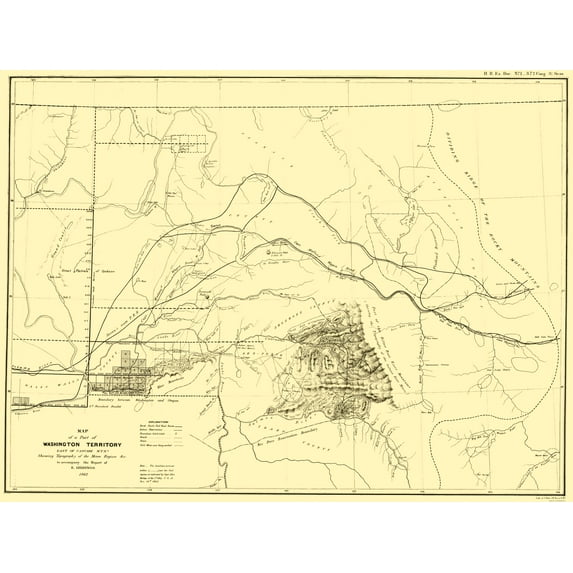
Old State Map - Washington Territory East of Cascade Mts - Bien 1862 - This is an exquisite full-color Reproduction printed on high-quality gloss paper, art paper or canvas.
Print Size: 23.00 x 30.44 inches
58.42 X 77.31cm
Sites and Townships Specific To This Map Are: Pinkneyville and Elk City.
The following towns are featured: waterways including Columbia River, Yakima River, Spokane River, Snake River, Palouse River, Salmon River, Coeur d'Alene Lake, Lake Pend Oreille, Tobacco River, Bitter Root River, Hell Gate River, Little Blackfoot River, and several other smaller tributaries. Emigrant routes notated are Capt Mullens Wagon Trail, Mullens Road, and the Wagon Road to Fort Benton. Indian Reservations locations are also shown.
This Map is Situated in: United States of America.
SKU: USNW0003
Original Maps are often difficult to find and usually have fold lines, identifying stamps or markings, tears, ragged edges, and assorted other natural signs of age that detract from their beauty. All of our maps have been professionally restored to depict their original beauty, while keeping all historical data intact.
These maps are fabulous pieces of history full of information useful to Historians, Genealogists, Cartographers, Relic Hunters, & Others. They make fascinating conversation pieces and splendid works of art for the home or office.
- OWN A STATE MAP TODAY - If you are looking for a map of your state, or another specific state, to frame and hang on your wall, then look no further! Our state maps are also great for school projects. Our maps have a variety of uses, and they come in a variety of styles. We have every state map you could need!
- STATE MAPS PROVIDE IMPORTANT INFORMATION - State maps not only show you how the different counties and/or cities are divided up and where the borders can be found within a state, but it also highlights rivers, mountains, and other natural elements. Some of them may also provide
- ONLY ACCEPT THE BEST PRINT QUALITY FOR YOUR REPRODUCTIONS - There are many printers and print types available on the market, when purchasing a reproduction there is no finer quality reproduction than a reproduction using the Giclee Printing method. Giclee describes the technique or style of printing used, and it is revered as the highest quality printing because of the way it precisely sprays ink onto a surface. Trust nothing less than the best!
- GUARNANTEED TO GET EXACTLY WHAT YOU ORDERED - This map comes exactly to the specification of 23.00 x 30.44 inches/58.42 X 77.31 cm. All of our maps come rolled, wrapped, and shipped in a heavy gauge mailing tube to ensure it arrives intact.
- WHY CHOOSE MAPS OF THE PAST? - Maps of the Past is one of the single largest producers of different types of maps. They legally own the rights to the maps they sell, and provide them to you in clean, clear, and vibrant print. If you are looking for a high quality map print, then look no further than Maps of the Past!
info:
We aim to show you accurate product information. Manufacturers, suppliers and others provide what you see here, and we have not verified it.
Specifications
Size
23.00 x 30.44
Material
Glossy Satin Photo Quality
Decor style
Vintage
Theme
Old State Maps
Warranty
Warranty information
Please be aware that the warranty terms on items offered for sale by third party Marketplace sellers may differ from those displayed in this section (if any). To confirm warranty terms on an item offered for sale by a third party Marketplace seller, please use the 'Contact seller' feature on the third party Marketplace seller's information page and request the item's warranty terms prior to purchase.
Customer ratings & reviews
0 ratings|0 reviews
This item does not have any reviews yet

Related pages
- Washington State Rivers Map
- Oregon Map By County
- South Carolina State Maps
- Jacksonville Florida Map
- California Missions Map
- Oregon Usa Map
- National Parks Posters
- Central America Travel Books, Maps & Guides
- Northeast United States Travel Books, Maps & Guides
- General South America Travel Books, Maps & Guides
- Caribbean & West Indies Travel Books, Maps & Guides
- Ontario Travel Books, Maps & Guides