Hero image 0 of Historic Map - Venice Italy - Baedeker 1886 - 23 x 32.54 - Vintage Wall Art, 0 of 5
Historic Map - Venice Italy - Baedeker 1886 - 23 x 32.54 - Vintage Wall Art
(No ratings yet)
Key item features
- OWN A PIECE OF YOUR HOME COUNTRY - Looking for something that reminds you of the country you or your ancestors originate from? Well now you can own a piece of your heritage with a beautiful map of your home country. Maps of the Past has maps for every need!
- INTERNATIONAL MAPS PROVIDE IMPORTANT INFORMATION - International maps not only show you how the different countries, cities, counties, and territories are divided and where the borders can be found, but it also highlights rivers, mountains, and other natural elements of the land. International maps can also show you natural resources and exports of a country.
- ONLY ACCEPT THE BEST PRINT QUALITY FOR YOUR REPRODUCTIONS - There are many printers and print types available on the market, when purchasing a reproduction there is no finer quality reproduction than a reproduction using the Giclee Printing method. Giclee describes the technique or style of printing used, and it is revered as the highest quality printing because of the way it precisely sprays ink onto a surface. Trust nothing less than the best!
- GUARNANTEED TO GET EXACTLY WHAT YOU ORDERED - This map comes exactly to the specification of 23.00 x 32.54 inches/58.42 X 82.65 cm. All of our maps come rolled, wrapped, and shipped in a heavy gauge mailing tube to ensure it arrives intact.
- WHY CHOOSE MAPS OF THE PAST? - Maps of the Past is one of the single largest producers of different types of maps. They legally own the rights to the maps they sell, and provide them to you in clean, clear, and vibrant print. If you are looking for a high quality map print, then look no further than Maps of the Past!
Specs
- Size23.00 x 32.54
- MaterialMatte Art
- Decor styleVintage
- ShapeRectangle
- Rec. roomOffice
- BrandMAPS OF THE PAST
Current price is USDNow $45.95
You save $29.00
was $74.95$74.95
You save$29.00
Price when purchased online
- Free shipping
 Free 30-day returns
How do you want your item?
Columbus, 43215
Arrives between Feb 28 - Mar 3
|Sold and shipped by Maps of the Past
4.3 stars out of 5, based on 10 seller reviews(4.3)10 seller reviews
Free 30-day returns
About this item
Product details
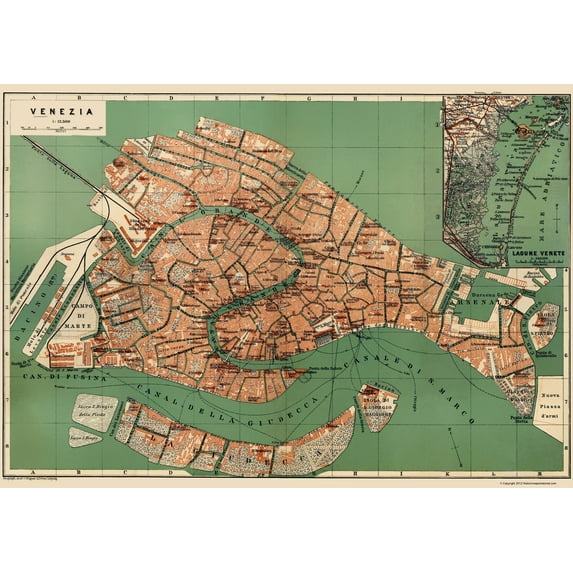
Old Italy Map - Venice - Wagner 1886 - This is an exquisite full-color Reproduction printed on high-quality gloss paper, art paper or canvas.
Print Size: 23.00 x 32.54 inches
58.42 X 82.65cm
Sites and Townships Specific To This Map Are: Venice.
The following towns are featured: a German firm that specialized in providing maps guidebooks maps for travelers, Wagner & Debes was published by Karl Baedeker in the 19th and early 20th centuries. Eduard Wagner founded the firm as a lithographic press in Darmstadt in 1835. In 1839, Baedeker gave a contract to Wagner for a regular supply of maps for his increasingly popular guidebooks. Driven by Baedeker∆s growth, the firm expanded steadily for the next several decades. In 1872, when Baedeker moved from Koblenz to Leipzig, Wagner also relocated. At the time of the move, Eduard∆s son Heinrich took over the business from his father. In Leipzig, he joined forces with Ernst Debes, a noted cartographer from the firm of Justus Perthes in Gotha, to form H. Wagner & E. Debes. In addition to its work for Baedeker, the firm published atlases and wall maps, especially for use in schools. This 1880s map of Venice is typical of the high-quality maps produced by the company
SKU: ITVE0001
Original Maps are often difficult to find and usually have fold lines, identifying stamps or markings, tears, ragged edges, and assorted other natural signs of age that detract from their beauty. All of our maps have been professionally restored to depict their original beauty, while keeping all historical data intact.
These maps are fabulous pieces of history full of information useful to Historians, Genealogists, Cartographers, Relic Hunters, & Others. They make fascinating conversation pieces and splendid works of art for the home or office.
- OWN A PIECE OF YOUR HOME COUNTRY - Looking for something that reminds you of the country you or your ancestors originate from? Well now you can own a piece of your heritage with a beautiful map of your home country. Maps of the Past has maps for every need!
- INTERNATIONAL MAPS PROVIDE IMPORTANT INFORMATION - International maps not only show you how the different countries, cities, counties, and territories are divided and where the borders can be found, but it also highlights rivers, mountains, and other natural elements of the land. International maps can also show you natural resources and exports of a country.
- ONLY ACCEPT THE BEST PRINT QUALITY FOR YOUR REPRODUCTIONS - There are many printers and print types available on the market, when purchasing a reproduction there is no finer quality reproduction than a reproduction using the Giclee Printing method. Giclee describes the technique or style of printing used, and it is revered as the highest quality printing because of the way it precisely sprays ink onto a surface. Trust nothing less than the best!
- GUARNANTEED TO GET EXACTLY WHAT YOU ORDERED - This map comes exactly to the specification of 23.00 x 32.54 inches/58.42 X 82.65 cm. All of our maps come rolled, wrapped, and shipped in a heavy gauge mailing tube to ensure it arrives intact.
- WHY CHOOSE MAPS OF THE PAST? - Maps of the Past is one of the single largest producers of different types of maps. They legally own the rights to the maps they sell, and provide them to you in clean, clear, and vibrant print. If you are looking for a high quality map print, then look no further than Maps of the Past!
info:
We aim to show you accurate product information. Manufacturers, suppliers and others provide what you see here, and we have not verified it.
Specifications
Size
23.00 x 32.54
Material
Matte Art
Decor style
Vintage
Theme
Historical International Maps
Warranty
Warranty information
Please be aware that the warranty terms on items offered for sale by third party Marketplace sellers may differ from those displayed in this section (if any). To confirm warranty terms on an item offered for sale by a third party Marketplace seller, please use the 'Contact seller' feature on the third party Marketplace seller's information page and request the item's warranty terms prior to purchase.
Similar items you might like
Based on what customers bought
Historic Map - Ireland - Ortelius 1598 - 23 x 30.05 - Vintage Wall Art $40.95
 4 optionsAvailable in additional 4 options$4095current price $40.95
Historic Map - Ireland - Ortelius 1598 - 23 x 30.05 - Vintage Wall Art
Historic State Map - Carolinas - Bowles 1736 - 23 x 31.13 - Vintage Wall Art $40.95
 3 optionsAvailable in additional 3 options$4095current price $40.95
Historic State Map - Carolinas - Bowles 1736 - 23 x 31.13 - Vintage Wall Art
Historic Map - Creuse Department France - Migeon 1869 - 23 x 27.09 - Vintage Wall Art $40.95
 3 optionsAvailable in additional 3 options$4095current price $40.95
Historic Map - Creuse Department France - Migeon 1869 - 23 x 27.09 - Vintage Wall Art
Historic Map - Ireland - Rathbun 1893 - 23 x 29.08 - Vintage Wall Art $40.95 $40.95/count
 3 optionsAvailable in additional 3 options$4095current price $40.95$40.95/count
Historic Map - Ireland - Rathbun 1893 - 23 x 29.08 - Vintage Wall Art
Historic Map - Africa Eastern - Blaeu 1635 - 23 x 29.39 - Vintage Wall Art $40.95 $40.95/count
 3 optionsAvailable in additional 3 options$4095current price $40.95$40.95/count
Historic Map - Africa Eastern - Blaeu 1635 - 23 x 29.39 - Vintage Wall Art
Historic Map - Wales - Blaeu 1645 - 23 x 29.25 - Vintage Wall Art $40.95 $40.95/count
 3 optionsAvailable in additional 3 options$4095current price $40.95$40.95/count
Historic Map - Wales - Blaeu 1645 - 23 x 29.25 - Vintage Wall Art
Historic Map - North America - Smiley 1842 - 23 x 29.44 - Vintage Wall Art $40.95 $40.95/count
 3 optionsAvailable in additional 3 options$4095current price $40.95$40.95/count
Historic Map - North America - Smiley 1842 - 23 x 29.44 - Vintage Wall Art
Historic Map - Arabian Peninsula- Blaeu 1662 - 23 x 28.50 - Vintage Wall Art $40.95 $40.95/count
 3 optionsAvailable in additional 3 options$4095current price $40.95$40.95/count
Historic Map - Arabian Peninsula- Blaeu 1662 - 23 x 28.50 - Vintage Wall Art
Historic Map - California Island - De Fer 1720 - 23 x 33.05 - Vintage Wall Art $40.95
 3 optionsAvailable in additional 3 options$4095current price $40.95
Historic Map - California Island - De Fer 1720 - 23 x 33.05 - Vintage Wall Art
Historic Map - Queens County Ireland - Bartholomew 1882 - 23 x 30.08 - Vintage Wall Art $40.95 $40.95/count
 3 optionsAvailable in additional 3 options$4095current price $40.95$40.95/count
Historic Map - Queens County Ireland - Bartholomew 1882 - 23 x 30.08 - Vintage Wall Art
Historic Map - Italy Spain Western Mediterranean - Wilkinson 1822 - 23 x 29 - Vintage Wall Art $40.95 $40.95/count
 3 optionsAvailable in additional 3 options$4095current price $40.95$40.95/count
Historic Map - Italy Spain Western Mediterranean - Wilkinson 1822 - 23 x 29 - Vintage Wall Art
Historic State Map - Oregon - USGLO 1866 - 23 x 29.50 - Vintage Wall Art $40.95
 3 optionsAvailable in additional 3 options$4095current price $40.95
Historic State Map - Oregon - USGLO 1866 - 23 x 29.50 - Vintage Wall Art
Historic Map - Northern Hemisphere - Thomson 1814 - 23 x 26.10 - Vintage Wall Art $40.95 $40.95/count
 3 optionsAvailable in additional 3 options$4095current price $40.95$40.95/count
Historic Map - Northern Hemisphere - Thomson 1814 - 23 x 26.10 - Vintage Wall Art
Historic Map - Germany - Tanner 1836 - 23 x 25.80 - Vintage Wall Art $40.95 $40.95/count
 3 optionsAvailable in additional 3 options$4095current price $40.95$40.95/count
Historic Map - Germany - Tanner 1836 - 23 x 25.80 - Vintage Wall Art
Historic Map - Liege Belgium - Blaeu 1649 - 23 x 41.20 - Vintage Wall Art $40.95
 3 optionsAvailable in additional 3 options$4095current price $40.95
Historic Map - Liege Belgium - Blaeu 1649 - 23 x 41.20 - Vintage Wall Art
Historic Mine Map - Calaveras County California Mines - Walkup 1845 - 29 x 23 - Vintage Wall Art $40.95
 3 optionsAvailable in additional 3 options$4095current price $40.95
Historic Mine Map - Calaveras County California Mines - Walkup 1845 - 29 x 23 - Vintage Wall Art
Historic State Map - New York - Lucas 1823 - 32 x 23 - Vintage Wall Art $40.95 $40.95/count
 3 optionsAvailable in additional 3 options$4095current price $40.95$40.95/count
Historic State Map - New York - Lucas 1823 - 32 x 23 - Vintage Wall Art
Historic Map - Spain Portugal - Finley 1832 - 23 x 29.39 - Vintage Wall Art $40.95
 3 optionsAvailable in additional 3 options$4095current price $40.95
Historic Map - Spain Portugal - Finley 1832 - 23 x 29.39 - Vintage Wall Art
Historic State Map - America Septentrionali - 1751 - 26.63 x 23 - Vintage Wall Art $40.95 $40.95/count
 3 optionsAvailable in additional 3 options$4095current price $40.95$40.95/count
Historic State Map - America Septentrionali - 1751 - 26.63 x 23 - Vintage Wall Art
Historic Map - Bohemia Czech Republic - Ortelius 1573 - 23 x 29.84 - Vintage Wall Art $40.95
 3 optionsAvailable in additional 3 options$4095current price $40.95
Historic Map - Bohemia Czech Republic - Ortelius 1573 - 23 x 29.84 - Vintage Wall Art
Customer ratings & reviews
0 ratings|0 reviews
This item does not have any reviews yet
