
Hero image 0 of Historic County Map - Paulding County Georgia - West 1896 - 23 x 27.42 - Vintage Wall Art, 0 of 5
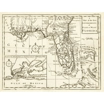
Historic County Map - Paulding County Georgia - West 1896 - 23 x 27.42 - Vintage Wall Art
(No ratings yet)
Historic County Map - Paulding County Georgia - West 1896 - 23 x 27.42 - Vintage Wall ArtHistoric County Map Paulding County Georgia West 1896 23 x 27 42 Vintage Wall ArtHistoric County Map Paulding County Georgia West 1896 23 x 27 42 Vintage Wall ArtHistoric County Map Paulding County Georgia West 1896 23 x 27 42 Vintage Wall Art
Material:Glossy Satin Photo Quality
Current price is USD$36.95
Price when purchased online
- Free shipping
- Free 30-day returns
How do you want your item?
Columbus, 43215
Arrives between Feb 14 - Feb 18
|Sold and shipped by Maps of the Past
4.3 stars out of 5, based on 10 seller reviews(4.3)
Free 30-day returns
| Product | Viewing this item |
|---|


| Size | 23.00 x 27.42Historic County Map - Paulding County Georgia - West 1896 - 23 x 27.42 - Vintage Wall Art | 23.00 x 23.00Historic County Map - Greene County Virginia - Hotchkiss 1875 - 23 x 23 - Vintage Wall Art | 23.00 x 30.19Historic County Map - Greenville County South Carolina - Salmon 1825 - 23 x 30.19 - Vintage Wall Art | 23.00 x 24.23Historic County Map - Nodaway County Missouri - Morehouse 1900 - 23 x 24.23 - Vintage Wall Art | 23.00 x 30.83Historic County Map - Montmorency County Michigan - Walling 1873 - 23 x 30.83 - Vintage Wall Art | 23.00 x 49.39Historic State Map - Virginia - 1918 - 49.39 x 23 - Vintage Wall Art | 23.00 x 28.84Historic County Map - Zavalla County Texas - Walsh 1879 - 28.84 x 23 - Vintage Wall Art | 23.00 x 30.08Historic State Map - Florida - Gibson 1763 - 30.08 x 23 - Vintage Wall Art | 23.00 x 24.15Historic County Map - Johnson County Texas - General Land Office 1887 - 24.14 x 23 - Vintage Wall Art | 23.00 x 27.73Historic State Map - Louisiana - Colton 1855 - 27.73 x 23 - Vintage Wall Art |
|---|---|---|---|---|---|---|---|---|---|---|
| Material | Glossy Satin Photo QualityHistoric County Map - Paulding County Georgia - West 1896 - 23 x 27.42 - Vintage Wall Art | Glossy Satin Photo QualityHistoric County Map - Greene County Virginia - Hotchkiss 1875 - 23 x 23 - Vintage Wall Art | Glossy Satin Photo QualityHistoric County Map - Greenville County South Carolina - Salmon 1825 - 23 x 30.19 - Vintage Wall Art | Glossy Satin Photo QualityHistoric County Map - Nodaway County Missouri - Morehouse 1900 - 23 x 24.23 - Vintage Wall Art | Glossy Satin Photo QualityHistoric County Map - Montmorency County Michigan - Walling 1873 - 23 x 30.83 - Vintage Wall Art | Glossy Satin Photo QualityHistoric State Map - Virginia - 1918 - 49.39 x 23 - Vintage Wall Art | Glossy Satin Photo QualityHistoric County Map - Zavalla County Texas - Walsh 1879 - 28.84 x 23 - Vintage Wall Art | Glossy Satin Photo QualityHistoric State Map - Florida - Gibson 1763 - 30.08 x 23 - Vintage Wall Art | Glossy Satin Photo QualityHistoric County Map - Johnson County Texas - General Land Office 1887 - 24.14 x 23 - Vintage Wall Art | Glossy Satin Photo QualityHistoric State Map - Louisiana - Colton 1855 - 27.73 x 23 - Vintage Wall Art |
| Decor style | VintageHistoric County Map - Paulding County Georgia - West 1896 - 23 x 27.42 - Vintage Wall Art | VintageHistoric County Map - Greene County Virginia - Hotchkiss 1875 - 23 x 23 - Vintage Wall Art | VintageHistoric County Map - Greenville County South Carolina - Salmon 1825 - 23 x 30.19 - Vintage Wall Art | -Historic County Map - Nodaway County Missouri - Morehouse 1900 - 23 x 24.23 - Vintage Wall Art | VintageHistoric County Map - Montmorency County Michigan - Walling 1873 - 23 x 30.83 - Vintage Wall Art | -Historic State Map - Virginia - 1918 - 49.39 x 23 - Vintage Wall Art | IndustrialHistoric County Map - Zavalla County Texas - Walsh 1879 - 28.84 x 23 - Vintage Wall Art | VintageHistoric State Map - Florida - Gibson 1763 - 30.08 x 23 - Vintage Wall Art | VintageHistoric County Map - Johnson County Texas - General Land Office 1887 - 24.14 x 23 - Vintage Wall Art | VintageHistoric State Map - Louisiana - Colton 1855 - 27.73 x 23 - Vintage Wall Art |
| Theme | Historical County MapsHistoric County Map - Paulding County Georgia - West 1896 - 23 x 27.42 - Vintage Wall Art | Historical County MapsHistoric County Map - Greene County Virginia - Hotchkiss 1875 - 23 x 23 - Vintage Wall Art | Historical County MapsHistoric County Map - Greenville County South Carolina - Salmon 1825 - 23 x 30.19 - Vintage Wall Art | Historical County MapsHistoric County Map - Nodaway County Missouri - Morehouse 1900 - 23 x 24.23 - Vintage Wall Art | Historical County MapsHistoric County Map - Montmorency County Michigan - Walling 1873 - 23 x 30.83 - Vintage Wall Art | Old State MapsHistoric State Map - Virginia - 1918 - 49.39 x 23 - Vintage Wall Art | Historical County MapsHistoric County Map - Zavalla County Texas - Walsh 1879 - 28.84 x 23 - Vintage Wall Art | Old State MapsHistoric State Map - Florida - Gibson 1763 - 30.08 x 23 - Vintage Wall Art | Historical County MapsHistoric County Map - Johnson County Texas - General Land Office 1887 - 24.14 x 23 - Vintage Wall Art | Old State MapsHistoric State Map - Louisiana - Colton 1855 - 27.73 x 23 - Vintage Wall Art |
Now hiding additional rows in the Table
About this item


![Historic Print, [Portrait of Georgia O'Keeffe, Abiquiu, N.M.], 18" x 24"](https://i5.walmartimages.com/asr/a6cedf84-6eca-4bd6-ab5b-1e33ab923271.ac65bf83f97ae1cbcab325602b499825.png?odnHeight=576&odnWidth=576&odnBg=FFFFFF)


Customer ratings & reviews
0 ratings|0 reviews
This item does not have any reviews yet

Related pages
- Council Bluffs Iowa Map
- Akron Ohio Map
- Kentucky Counties Map
- Colorado Springs Map
- Macon Georgia Map
- Tallahassee Florida Map
- National Parks Posters
- General South America Travel Books, Maps & Guides
- Central America Travel Books, Maps & Guides
- Northeast United States Travel Books, Maps & Guides
- Midwest United States Travel Books, Maps & Guides
- Ontario Travel Books, Maps & Guides