
Hero image 0 of Historic Nautical Map - Bahamas Cuba Jamaica Sea Chart - Jansson 1650 - 23 x 28 - Vintage Wall Art, 0 of 5
Historic Nautical Map - Bahamas Cuba Jamaica Sea Chart - Jansson 1650 - 23 x 28 - Vintage Wall Art
(No ratings yet)
Key item features
- CHECK OUT OUR BEAUTIFUL NAUTICAL MAPS - Water covers three quarters of the planet and waterways are vital for getting goods from one part of the globe to another. Nautical maps show you exactly what routes are most commonly used between various ports and how those goods are moved.
- NAUTICAL MAPS MAKE GREAT WALL ART - Are you looking for something new to add to a beach house? Are you a boating enthusiast who collects nautical memorabilia? Nautical maps are a wonderful compliment to any room.
- ONLY ACCEPT THE BEST PRINT QUALITY FOR YOUR REPRODUCTIONS - There are many printers and print types available on the market, when purchasing a reproduction there is no finer quality reproduction than a reproduction using the Giclee Printing method. Giclee describes the technique or style of printing used, and it is revered as the highest quality printing because of the way it precisely sprays ink onto a surface. Trust nothing less than the best!
- GUARNANTEED TO GET EXACTLY WHAT YOU ORDERED - This map comes exactly to the specification of 23.00 x 28.86 inches/58.42 X 73.30 cm. All of our maps come rolled, wrapped, and shipped in a heavy gauge mailing tube to ensure it arrives intact.
- WHY CHOOSE MAPS OF THE PAST? - Maps of the Past is one of the single largest producers of different types of maps. They legally own the rights to the maps they sell, and provide them to you in clean, clear, and vibrant print. If you are looking for a high quality map print, then look no further than Maps of the Past!
Specs
- Size23.00 x 28.86
- MaterialMatte Art
- Decor styleVintage
- ShapeRectangle
- Rec. roomOffice
- BrandMAPS OF THE PAST
Current price is USD$45.95$45.95/count
Price when purchased online
- Free shipping
 Free 30-day returns
How do you want your item?
Columbus, 43215
Arrives by Mon, Apr 13
|Sold and shipped by Maps of the Past
4.3 stars out of 5, based on 10 seller reviews(4.3)10 seller reviews
Free 30-day returns
About this item
Product details
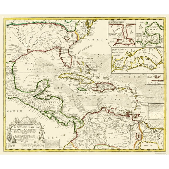
Old Caribbean Map - Bahamas, Cuba, Jamaica, Hispaniola Sea Chart 1650 - This is an exquisite full-color Reproduction printed on high-quality gloss paper, art paper or canvas.
Print Size: 23.00 x 28.86 inches
58.42 X 73.30cm
The following towns are featured: sea chart including the Bahamas, Cuba, Jamaica, Hispaniola, and the southern tip of Florida. It was one of the first Dutch maps to feature th region on a large scale, due to the importance of the "Canaal van Bahama to the transport of Spanish gold and silver from the New World. Cartographically based on the extremely rare Hessel Gerritsz chart of 1631, with the addition of five place names in Florida. Jansson also depicts a spurious mountain range in Florida, was taken from the much earlier de Bry map. The map is embellished with a pictorial title cartouche and scale of miles, rhumb lines, galleons and two compass roses, wtih French text on the verso.
This Map is Situated in: Caribbean Sea.
SKU: ITBA0021
Original Maps are often difficult to find and usually have fold lines, identifying stamps or markings, tears, ragged edges, and assorted other natural signs of age that detract from their beauty. All of our maps have been professionally restored to depict their original beauty, while keeping all historical data intact.
These maps are fabulous pieces of history full of information useful to Historians, Genealogists, Cartographers, Relic Hunters, & Others. They make fascinating conversation pieces and splendid works of art for the home or office.
- CHECK OUT OUR BEAUTIFUL NAUTICAL MAPS - Water covers three quarters of the planet and waterways are vital for getting goods from one part of the globe to another. Nautical maps show you exactly what routes are most commonly used between various ports and how those goods are moved.
- NAUTICAL MAPS MAKE GREAT WALL ART - Are you looking for something new to add to a beach house? Are you a boating enthusiast who collects nautical memorabilia? Nautical maps are a wonderful compliment to any room.
- ONLY ACCEPT THE BEST PRINT QUALITY FOR YOUR REPRODUCTIONS - There are many printers and print types available on the market, when purchasing a reproduction there is no finer quality reproduction than a reproduction using the Giclee Printing method. Giclee describes the technique or style of printing used, and it is revered as the highest quality printing because of the way it precisely sprays ink onto a surface. Trust nothing less than the best!
- GUARNANTEED TO GET EXACTLY WHAT YOU ORDERED - This map comes exactly to the specification of 23.00 x 28.86 inches/58.42 X 73.30 cm. All of our maps come rolled, wrapped, and shipped in a heavy gauge mailing tube to ensure it arrives intact.
- WHY CHOOSE MAPS OF THE PAST? - Maps of the Past is one of the single largest producers of different types of maps. They legally own the rights to the maps they sell, and provide them to you in clean, clear, and vibrant print. If you are looking for a high quality map print, then look no further than Maps of the Past!
info:
We aim to show you accurate product information. Manufacturers, suppliers and others provide what you see here, and we have not verified it.
Specifications
Size
23.00 x 28.86
Material
Matte Art
Decor style
Vintage
Theme
Historical International Maps
Warranty
Warranty information
Please be aware that the warranty terms on items offered for sale by third party Marketplace sellers may differ from those displayed in this section (if any). To confirm warranty terms on an item offered for sale by a third party Marketplace seller, please use the 'Contact seller' feature on the third party Marketplace seller's information page and request the item's warranty terms prior to purchase.
Similar items you might like
Based on what customers bought
100+ bought since yesterday Home Decor Collection Black Round Wall Art or Tabletop, White Rose Floral Print by Antoine Monnoyer with Gold Beaded Frame, Classic Decorative Artwork, 6x8 $7.83
100+ bought since yesterday $783current price $7.83
Home Decor Collection Black Round Wall Art or Tabletop, White Rose Floral Print by Antoine Monnoyer with Gold Beaded Frame, Classic Decorative Artwork, 6x8
1884.7 out of 5 Stars. 188 reviewsHistoric Revolutionary War Map - New England North America - Homann 1780 - 23 x 32.26 - Vintage Wall Art $94.95 $94.95/count
 3 optionsAvailable in additional 3 options$9495current price $94.95$94.95/count
Historic Revolutionary War Map - New England North America - Homann 1780 - 23 x 32.26 - Vintage Wall Art
Historic Map - South Mayne Germany - Thomson 1816 - 23 x 28.09 - Vintage Wall Art $94.95
 3 optionsAvailable in additional 3 options$9495current price $94.95
Historic Map - South Mayne Germany - Thomson 1816 - 23 x 28.09 - Vintage Wall Art
Historic Map - New Spain Mexico Texas - De Lafora 1771 - 23 x 52 - Vintage Wall Art $94.95 $94.95/count
 3 optionsAvailable in additional 3 options$9495current price $94.95$94.95/count
Historic Map - New Spain Mexico Texas - De Lafora 1771 - 23 x 52 - Vintage Wall Art
Historic Nautical Map - New York Harbor - Blunt 1827 - 23 x 32.78 - Vintage Wall Art $94.95 $94.95/count
 3 optionsAvailable in additional 3 options$9495current price $94.95$94.95/count
Historic Nautical Map - New York Harbor - Blunt 1827 - 23 x 32.78 - Vintage Wall Art
Historic Map - Western Hemisphere - Gutierrez 1562 - 23 x 26.10 - Vintage Wall Art $94.95 $94.95/count
 3 optionsAvailable in additional 3 options$9495current price $94.95$94.95/count
Historic Map - Western Hemisphere - Gutierrez 1562 - 23 x 26.10 - Vintage Wall Art
Historic Map - West Indies America Islands - Visscher 1740 - 27 x 23 - Vintage Wall Art $94.95 $94.95/count
 3 optionsAvailable in additional 3 options$9495current price $94.95$94.95/count
Historic Map - West Indies America Islands - Visscher 1740 - 27 x 23 - Vintage Wall Art
Stupell Industries Vintage Garden Cabbage Food & Beverage Painting Unframed Art Print Wall Art, 11 x 14, Set of 4 $117.99
 $11799current price $117.99
Stupell Industries Vintage Garden Cabbage Food & Beverage Painting Unframed Art Print Wall Art, 11 x 14, Set of 4
Historic Map - Europe Near East Commercial Chart - Newnes 1907 - 23 x 26.79 - Vintage Wall Art $94.95 $94.95/count
 3 optionsAvailable in additional 3 options$9495current price $94.95$94.95/count
Historic Map - Europe Near East Commercial Chart - Newnes 1907 - 23 x 26.79 - Vintage Wall Art
Historic Revolutionary War Map - North America Latest Discoveries - 1750 - 23 x 30 - Vintage Wall Art $94.95 $94.95/count
 3 optionsAvailable in additional 3 options$9495current price $94.95$94.95/count
Historic Revolutionary War Map - North America Latest Discoveries - 1750 - 23 x 30 - Vintage Wall Art
Historic City Map - Jacksonville St Johns River Florida - Rocque 1791 - 23 x 40.65 - Vintage Wall Art $94.95
 $9495current price $94.95
Historic City Map - Jacksonville St Johns River Florida - Rocque 1791 - 23 x 40.65 - Vintage Wall Art
Historic Revolutionary War Map - North America English Colonies - Overton 1756 - 23 x 32.44 - Vintage Wall Art $94.95 $94.95/count
 3 optionsAvailable in additional 3 options$9495current price $94.95$94.95/count
Historic Revolutionary War Map - North America English Colonies - Overton 1756 - 23 x 32.44 - Vintage Wall Art
Old Travel Map - Alaska Excursion Steamers, N Pacific Railroad 1891 - 23 x 47 $94.95 $94.95/count
 2 optionsAvailable in additional 2 options$9495current price $94.95$94.95/count
Old Travel Map - Alaska Excursion Steamers, N Pacific Railroad 1891 - 23 x 47
Historic State Map - Virginia - 1644 - 26.96 x 23 - Vintage Wall Art $94.95 $94.95/count
 3 optionsAvailable in additional 3 options$9495current price $94.95$94.95/count
Historic State Map - Virginia - 1644 - 26.96 x 23 - Vintage Wall Art
Historic State Map - South Carolina - Rathbun 1893 - 23 x 28.43 - Vintage Wall Art $40.95 $40.95/count
 3 optionsAvailable in additional 3 options$4095current price $40.95$40.95/count
Historic State Map - South Carolina - Rathbun 1893 - 23 x 28.43 - Vintage Wall Art
Historic Map - South America - Stieler 1852 - 23 x 25.89 - Vintage Wall Art $40.95 $40.95/count
 4 optionsAvailable in additional 4 options$4095current price $40.95$40.95/count
Historic Map - South America - Stieler 1852 - 23 x 25.89 - Vintage Wall Art
Historic War Map - San Juan Battle Map 1 - McClurg 1907 - 23 x 36.70 - Vintage Wall Art $40.95
 3 optionsAvailable in additional 3 options$4095current price $40.95
Historic War Map - San Juan Battle Map 1 - McClurg 1907 - 23 x 36.70 - Vintage Wall Art
Historic Nautical Map - Florida Louisiana Gulf Coast - Sartine 1778 - 23 x 33.11 - Vintage Wall Art $40.95
 3 optionsAvailable in additional 3 options$4095current price $40.95
Historic Nautical Map - Florida Louisiana Gulf Coast - Sartine 1778 - 23 x 33.11 - Vintage Wall Art
Historic Map - Africa - Cumming 1817 - 23 x 28.47 - Vintage Wall Art $40.95
 3 optionsAvailable in additional 3 options$4095current price $40.95
Historic Map - Africa - Cumming 1817 - 23 x 28.47 - Vintage Wall Art

Customer ratings & reviews
0 ratings|0 reviews
This item does not have any reviews yet

Related pages
- Puget Sound Nautical Map
- Map Of Caribbean Islands
- Nc Lighthouses Map
- Hawaii Volcanoes Map
- Map Caribbean Islands
- Lighthouses Florida Map
- Caribbean & West Indies Travel Books, Maps & Guides
- National Parks Posters
- Iceland & Greenland Travel Books
- Australia & Oceania Travel Books, Maps & Guides
- Cyprus Travel Books
- Rough Guides Travel Books, Maps & Guides