Hero image 0 of Revolutionary War Map Print - United States - Lattre 1784 - Vintage Wall Art, 0 of 4
Revolutionary War Map Print - United States - Lattre 1784 - Vintage Wall Art
(No ratings yet)
Revolutionary War Map Print - United States - Lattre 1784 - Vintage Wall ArtHistoric Revolutionary War Map United States Lattre 1784 23 x 27 95 Vintage Wall ArtHistoric Revolutionary War Map United States Lattre 1784 23 x 27 95 Vintage Wall ArtRevolutionary War Map Print United States Lattre 1784 Vintage Wall ArtRevolutionary War Map Print United States Lattre 1784 Vintage Wall Art
Material:Glossy Photo
Size:23.00 x 40.98
Key item features
- MAP OF THE REVOLUTIONARY WAR ERA - Ever wonder what a certain state or region looked like during the Revolutionary War? Now you can see for yourself and own a piece of USA history! We have maps of colonies, states, all the way up to the entire eastern half of North America. Our maps date back to as early as the 1700's!
- A GREAT COMPLIMENT TO ANY COLLECTION - If you are a Revolutionary war-buff, then you likely own a number of pieces of memorabelia from that era. Some items may be replica's, and some items may be originals. A beautiful map from the Revolutionary War era is a great compliment to any collection room!
- ONLY ACCEPT THE BEST PRINT QUALITY FOR YOUR REPRODUCTIONS - There are many printers and print types available on the market, when purchasing a reproduction there is no finer quality reproduction than a reproduction using the Giclee Printing method. Giclee describes the technique or style of printing used, and it is revered as the highest quality printing because of the way it precisely sprays ink onto a surface. Trust nothing less than the best!
- GUARANTEED TO GET EXACTLY WHAT YOU ORDERED - All of our maps come rolled, wrapped, and shipped in a heavy gauge mailing tube to ensure it arrives intact.
- WHY CHOOSE MAPS OF THE PAST? - Maps of the Past is one of the single largest producers of different types of maps. They legally own the rights to the maps they sell, and provide them to you in clean, clear, and vibrant print. If you are looking for a high quality map print, then look no further than Maps of the Past!
Specs
- ColorMulticolor
- Decor styleIndustrial
- ThemeRevolutionary War Maps
- FramedN
- ShapeRectangle
- Art typePhotography
Current price is USD$40.95$40.95/count
Price when purchased online
- Free shipping
 Free 30-day returns
How do you want your item?
Ships to
Arrives between May 23 - May 26
|Sold and shipped by Maps of the Past
4.363636363636363 stars out of 5, based on 11 seller reviews(4.4)11 seller reviews
Free 30-day returns
About this item
Product details
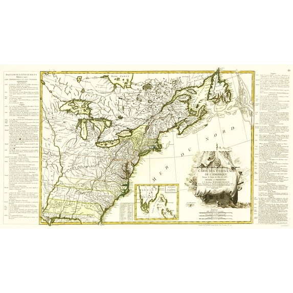
Old Revolutionary War Map - United States of America 1784 - This is an exquisite full-color Reproduction printed on gloss paper or art paper.
Sites and Townships Specific To This Map Are: Charlestown, Boston, Philadelphia, Albany, Plymouth, Annapolis, Montreal, Augusta, and several other towns and settlements throughout the east coast.
The following towns are featured: Antique map written in German features Canda, New Scotland, Acadia, New York, Massachusets, Maine, New Hampshire, Connecticut, Rhode Island, New Jersey, Pennsylvania, Maryland, Virgina, North Carolina, Georgia, Florida, Louisiana, Lake Erie, Lake Ontario, Lake Michigan, Lake Huron, Lake Superior, and the Mississippi River.
This Map is Situated in: Eastern North America
SKU: REWA0104
Original Maps are often difficult to find and usually have fold lines, identifying stamps or markings, tears, ragged edges, and assorted other natural signs of age that detract from their beauty. All of our maps have been professionally restored to depict their original beauty, while keeping all historical data intact.
These maps are fabulous pieces of history full of information useful to Historians, Genealogists, Cartographers, Relic Hunters, & Others. They make fascinating conversation pieces and splendid works of art for the home or office.
- MAP OF THE REVOLUTIONARY WAR ERA - Ever wonder what a certain state or region looked like during the Revolutionary War? Now you can see for yourself and own a piece of USA history! We have maps of colonies, states, all the way up to the entire eastern half of North America. Our maps date back to as early as the 1700's!
- A GREAT COMPLIMENT TO ANY COLLECTION - If you are a Revolutionary war-buff, then you likely own a number of pieces of memorabelia from that era. Some items may be replica's, and some items may be originals. A beautiful map from the Revolutionary War era is a great compliment to any collection room!
- ONLY ACCEPT THE BEST PRINT QUALITY FOR YOUR REPRODUCTIONS - There are many printers and print types available on the market, when purchasing a reproduction there is no finer quality reproduction than a reproduction using the Giclee Printing method. Giclee describes the technique or style of printing used, and it is revered as the highest quality printing because of the way it precisely sprays ink onto a surface. Trust nothing less than the best!
- GUARANTEED TO GET EXACTLY WHAT YOU ORDERED - All of our maps come rolled, wrapped, and shipped in a heavy gauge mailing tube to ensure it arrives intact.
- WHY CHOOSE MAPS OF THE PAST? - Maps of the Past is one of the single largest producers of different types of maps. They legally own the rights to the maps they sell, and provide them to you in clean, clear, and vibrant print. If you are looking for a high quality map print, then look no further than Maps of the Past!
info:
We aim to show you accurate product information. Manufacturers, suppliers and others provide what you see here, and we have not verified it.
Specifications
Color
Multicolor
Decor style
Industrial
Theme
Revolutionary War Maps
Framed
N
Warranty
Warranty information
Please be aware that the warranty terms on items offered for sale by third party Marketplace sellers may differ from those displayed in this section (if any). To confirm warranty terms on an item offered for sale by a third party Marketplace seller, please use the 'Contact seller' feature on the third party Marketplace seller's information page and request the item's warranty terms prior to purchase.
Similar items you might like
Based on what customers bought
In 50+ people's carts Home Decor Collection Gold Metro Beaded Oval Framed Landscape Wall Art, Vintage-Style Décor for Living Room, Entryway, Bedroom, or Office, 14x11 $7.49
In 50+ people's carts $749current price $7.49
Home Decor Collection Gold Metro Beaded Oval Framed Landscape Wall Art, Vintage-Style Décor for Living Room, Entryway, Bedroom, or Office, 14x11
1964.4 out of 5 Stars. 196 reviewsHistoric Map - Caribbean Islands - Smollett 1761 - Vintage Wall Art $36.95
 $3695current price $36.95
Historic Map - Caribbean Islands - Smollett 1761 - Vintage Wall Art
Revolutionary War Map Print - Boston Harbour Environs - Page 1775 - Vintage Wall Art $45.95 $45.95/count
 $4595current price $45.95$45.95/count
Revolutionary War Map Print - Boston Harbour Environs - Page 1775 - Vintage Wall Art
Historic Map - British Empire World - Fullarton 1864 - Vintage Wall Art $45.95
 4 optionsAvailable in additional 4 options$4595current price $45.95
Historic Map - British Empire World - Fullarton 1864 - Vintage Wall Art
Historic Map - North America - Smiley 1842 - Vintage Wall Art $45.95
 3 optionsAvailable in additional 3 options$4595current price $45.95
Historic Map - North America - Smiley 1842 - Vintage Wall Art
Old War Map - North America English French Possessions - Ottens 1755 - Vintage Wall Art $45.95 $45.95/count
 $4595current price $45.95$45.95/count
Old War Map - North America English French Possessions - Ottens 1755 - Vintage Wall Art
Old War Map - Virginia Major General Lafayette Campaign - Michel 1781 - Vintage Wall Art $45.95 $45.95/count
 $4595current price $45.95$45.95/count
Old War Map - Virginia Major General Lafayette Campaign - Michel 1781 - Vintage Wall Art
Historic State Map - Maryland Delaware - Rathbun 1893 - Vintage Wall Art $45.95
 $4595current price $45.95
Historic State Map - Maryland Delaware - Rathbun 1893 - Vintage Wall Art
Historic State Map - Washington Territory West Cascades - Duval 1857 - Vintage Wall Art $45.95 $45.95/count
 $4595current price $45.95$45.95/count
Historic State Map - Washington Territory West Cascades - Duval 1857 - Vintage Wall Art
Historic Map - Arabian Peninsula- Blaeu 1662 - Vintage Wall Art $45.95 $45.95/count
 $4595current price $45.95$45.95/count
Historic Map - Arabian Peninsula- Blaeu 1662 - Vintage Wall Art
Historic State Map - New York - Lucas 1823 - Vintage Wall Art $45.95 $45.95/count
 $4595current price $45.95$45.95/count
Historic State Map - New York - Lucas 1823 - Vintage Wall Art
Historic State Map - America Septentrionali - 1751 - Vintage Wall Art $36.95
 $3695current price $36.95
Historic State Map - America Septentrionali - 1751 - Vintage Wall Art
Historic State Map - Florida - Mitchell 1846 - Vintage Wall Art $36.95
 4 optionsAvailable in additional 4 options$3695current price $36.95
Historic State Map - Florida - Mitchell 1846 - Vintage Wall Art
Historic Map - California Island - De Fer 1720 - Vintage Wall Art $45.95
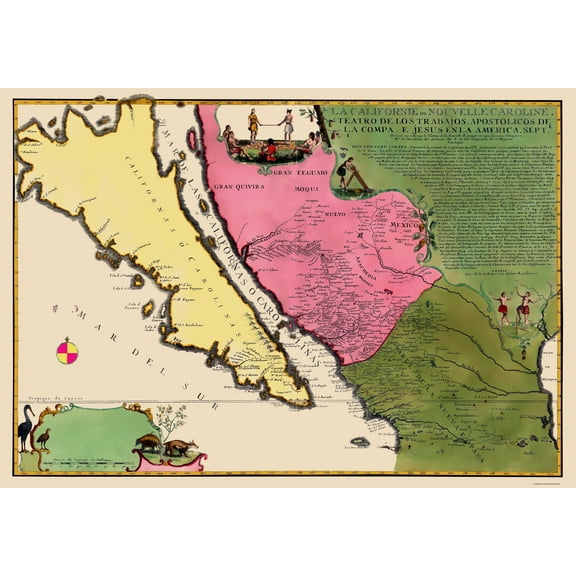 $4595current price $45.95
Historic Map - California Island - De Fer 1720 - Vintage Wall Art
Historic State Map - Kentucky - Stockdale 1794 - Vintage Wall Art $45.95
 $4595current price $45.95
Historic State Map - Kentucky - Stockdale 1794 - Vintage Wall Art
Historic State Map - Michigan - Greenleaf 1841 - Vintage Wall Art $45.95 $45.95/count
 4 optionsAvailable in additional 4 options$4595current price $45.95$45.95/count
Historic State Map - Michigan - Greenleaf 1841 - Vintage Wall Art
Historic State Map - United States - Wallis 1783 - Vintage Wall Art $45.95 $45.95/count
 4 optionsAvailable in additional 4 options$4595current price $45.95$45.95/count
Historic State Map - United States - Wallis 1783 - Vintage Wall Art
Historical Civil War Map - Carolinas Virginia Coasts- Prang 1863 - Vintage Wall Art $45.95 $45.95/count
 $4595current price $45.95$45.95/count
Historical Civil War Map - Carolinas Virginia Coasts- Prang 1863 - Vintage Wall Art
Historic Map - North South America - Seutter 1745 - Vintage Wall Art $36.95
 $3695current price $36.95
Historic Map - North South America - Seutter 1745 - Vintage Wall Art
Historic County Map - Herkimer County New York - Burr 1829 - Vintage Wall Art $45.95 $45.95/count
 $4595current price $45.95$45.95/count
Historic County Map - Herkimer County New York - Burr 1829 - Vintage Wall Art
Customer ratings & reviews
0 ratings|0 reviews
This item does not have any reviews yet
