
Hero image 0 of Railroad Map - Missouri Railway - McHenry 1888 - Vintage Wall Art, 0 of 4
Railroad Map - Missouri Railway - McHenry 1888 - Vintage Wall Art
(No ratings yet)
Railroad Map - Missouri Railway - McHenry 1888 - Vintage Wall ArtRailroad Map Missouri Railway McHenry 1888 23 x 26 45 Vintage Wall ArtRailroad Map Missouri Railway McHenry 1888 23 x 26 45 Vintage Wall ArtRailroad Map Missouri Railway McHenry 1888 Vintage Wall ArtRailroad Map Missouri Railway McHenry 1888 Vintage Wall Art
Material:Glossy Photo
Size:23.00 x 26.45
Key item features
- WHAT IS A RAILROAD SYSTEM? - Railroad systems were the original means of transporting both goods and people across the US, and many other countries across the globe. Railroads were built beginning in the 1800's and grew rapidly. They span coast to coast and are still heavily used today in many countries.
- ARE YOU A RAILROAD ENTHUSIAST? - If so, then add to your collection with prints of the original mappings of the railroad systems. Compare it against what is present today and see how much or how little it has changed since it's inceptions likely more than 100 years ago.
- ONLY ACCEPT THE BEST PRINT QUALITY FOR YOUR REPRODUCTIONS - There are many printers and print types available on the market, when purchasing a reproduction there is no finer quality reproduction than a reproduction using the Giclee Printing method. Giclee describes the technique or style of printing used, and it is revered as the highest quality printing because of the way it precisely sprays ink onto a surface. Trust nothing less than the best!
- GUARANTEED TO GET EXACTLY WHAT YOU ORDERED - All of our maps come rolled, wrapped, and shipped in a heavy gauge mailing tube to ensure it arrives intact.
- WHY CHOOSE MAPS OF THE PAST? - Maps of the Past is one of the single largest producers of different types of maps. They legally own the rights to the maps they sell, and provide them to you in clean, clear, and vibrant print. If you are looking for a high quality map print, then look no further than Maps of the Past!
Specs
- ColorMulticolor
- Size23.00 x 26.45
- MaterialGlossy Photo
- Decor styleIndustrial
- ThemeOld Railroad Maps
- FramedN
Current price is USD$40.95
Price when purchased online
- Free shipping
 Free 30-day returns
How do you want your item?
Ships to
Arrives between May 23 - May 26
|Sold and shipped by Maps of the Past
4.363636363636363 stars out of 5, based on 11 seller reviews(4.4)11 seller reviews
Free 30-day returns
About this item
Product details
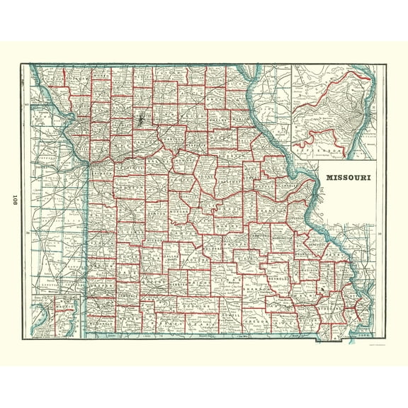
Old Railroad Map - Missouri Railway Map - McHenry 1888 - This is an exquisite full-color Reproduction printed on gloss paper or art paper.
Sites and Townships Specific To This Map Are: Waynesville, Frank, Dixon, Richland, Sleeper, Brush Creek, Phillipsburgh, Conway, Niangua, Condray, Avery, Howes, Salem, Wilsons Mill, Keysville, Cherry valley, Ferfuson, Steelville, Midland, Halberts, Bourbon, Sullivan, Stanton, St. Clair, Vienna and many others.
The following towns are featured: rail lines including the KC & CB, St Jo & G Isl, KC St Jo & CB, Wabash Western, Chicago Burlington Quincy, Chi Burlington & Kansas City, Wabash Western, Wabash Western Way, Kan Neb & Dak Div, and St Louis Iron Mountain & Southern.
This Map is Situated in: Missouri, (MO)
SKU: MOZZ0006
Original Maps are often difficult to find and usually have fold lines, identifying stamps or markings, tears, ragged edges, and assorted other natural signs of age that detract from their beauty. All of our maps have been professionally restored to depict their original beauty, while keeping all historical data intact.
These maps are fabulous pieces of history full of information useful to Historians, Genealogists, Cartographers, Relic Hunters, & Others. They make fascinating conversation pieces and splendid works of art for the home or office.
- WHAT IS A RAILROAD SYSTEM? - Railroad systems were the original means of transporting both goods and people across the US, and many other countries across the globe. Railroads were built beginning in the 1800's and grew rapidly. They span coast to coast and are still heavily used today in many countries.
- ARE YOU A RAILROAD ENTHUSIAST? - If so, then add to your collection with prints of the original mappings of the railroad systems. Compare it against what is present today and see how much or how little it has changed since it's inceptions likely more than 100 years ago.
- ONLY ACCEPT THE BEST PRINT QUALITY FOR YOUR REPRODUCTIONS - There are many printers and print types available on the market, when purchasing a reproduction there is no finer quality reproduction than a reproduction using the Giclee Printing method. Giclee describes the technique or style of printing used, and it is revered as the highest quality printing because of the way it precisely sprays ink onto a surface. Trust nothing less than the best!
- GUARANTEED TO GET EXACTLY WHAT YOU ORDERED - All of our maps come rolled, wrapped, and shipped in a heavy gauge mailing tube to ensure it arrives intact.
- WHY CHOOSE MAPS OF THE PAST? - Maps of the Past is one of the single largest producers of different types of maps. They legally own the rights to the maps they sell, and provide them to you in clean, clear, and vibrant print. If you are looking for a high quality map print, then look no further than Maps of the Past!
info:
We aim to show you accurate product information. Manufacturers, suppliers and others provide what you see here, and we have not verified it.
Specifications
Color
Multicolor
Size
23.00 x 26.45
Material
Glossy Photo
Decor style
Industrial
Warranty
Warranty information
Please be aware that the warranty terms on items offered for sale by third party Marketplace sellers may differ from those displayed in this section (if any). To confirm warranty terms on an item offered for sale by a third party Marketplace seller, please use the 'Contact seller' feature on the third party Marketplace seller's information page and request the item's warranty terms prior to purchase.
Similar items you might like
Based on what customers bought
In 50+ people's carts Home Decor Collection Gold Metro Beaded Oval Framed Landscape Wall Art, Vintage-Style Décor for Living Room, Entryway, Bedroom, or Office, 14x11 $7.49
In 50+ people's carts $749current price $7.49
Home Decor Collection Gold Metro Beaded Oval Framed Landscape Wall Art, Vintage-Style Décor for Living Room, Entryway, Bedroom, or Office, 14x11
1964.4 out of 5 Stars. 196 reviewsTopographical Map - Tennessee Outline Geographical - Mendenhall 1866 - Vintage Wall Art $36.95
 $3695current price $36.95
Topographical Map - Tennessee Outline Geographical - Mendenhall 1866 - Vintage Wall Art
Railroad Map - Texas Railroads - Dodge 1926 - Vintage Wall Art $36.95
 $3695current price $36.95
Railroad Map - Texas Railroads - Dodge 1926 - Vintage Wall Art
Railroad Map - Missouri Railway Mail Service - Galbraith 1897 - Vintage Wall Art $36.95
 $3695current price $36.95
Railroad Map - Missouri Railway Mail Service - Galbraith 1897 - Vintage Wall Art
Historic State Map - Missouri - Burr 1835 - Vintage Wall Art $36.95
 $3695current price $36.95
Historic State Map - Missouri - Burr 1835 - Vintage Wall Art
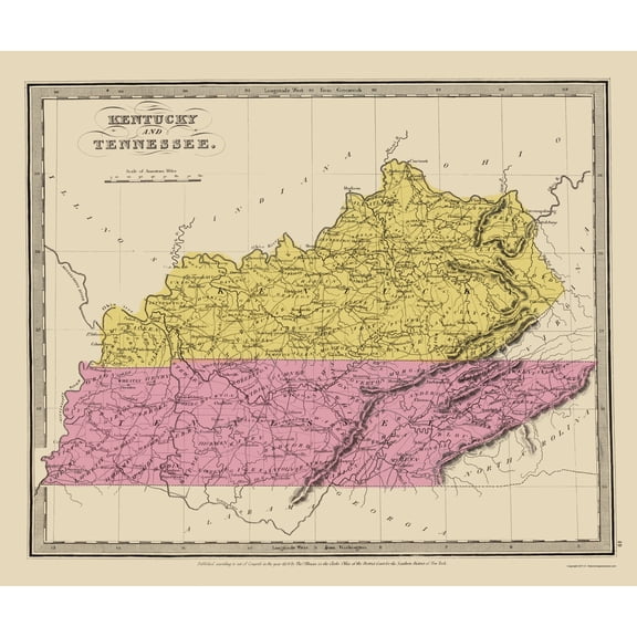
Historic State Map - Kentucky Tennessee - Illman 1834 - Vintage Wall Art $36.95
 $3695current price $36.95
Historic State Map - Kentucky Tennessee - Illman 1834 - Vintage Wall Art
Railroad Map - Indiana Railroads - Morris 1852 - Vintage Wall Art $36.95
 $3695current price $36.95
Railroad Map - Indiana Railroads - Morris 1852 - Vintage Wall Art
Historic State Map - Massachusetts Region - 1776 - Vintage Wall Art $36.95
 $3695current price $36.95
Historic State Map - Massachusetts Region - 1776 - Vintage Wall Art
Historic City Map - Farmington Pennsylvania - Caldwell 1877 - Vintage Wall Art $36.95
 $3695current price $36.95
Historic City Map - Farmington Pennsylvania - Caldwell 1877 - Vintage Wall Art
Historic State Map - Maine - 1890 - Vintage Wall Art $36.95
 $3695current price $36.95
Historic State Map - Maine - 1890 - Vintage Wall Art
Historic County Map - Chittenden County Vermont - Beers 1878 - Vintage Wall Art $36.95
 3 optionsAvailable in additional 3 options$3695current price $36.95
Historic County Map - Chittenden County Vermont - Beers 1878 - Vintage Wall Art
Historic State Map - Rhode Island - Bohn 1797 - Vintage Wall Art $36.95
 4 optionsAvailable in additional 4 options$3695current price $36.95
Historic State Map - Rhode Island - Bohn 1797 - Vintage Wall Art
Historic State Map - Missouri - Rathbun 1893 - Vintage Wall Art $36.95
 $3695current price $36.95
Historic State Map - Missouri - Rathbun 1893 - Vintage Wall Art
Historic Map - Warwickshire County England - Cary 1792 - Vintage Wall Art $36.95
 $3695current price $36.95
Historic Map - Warwickshire County England - Cary 1792 - Vintage Wall Art
Historic State Map - Louisiana Surrounding Territories - Delifle 1718 - Vintage Wall Art $36.95
 $3695current price $36.95
Historic State Map - Louisiana Surrounding Territories - Delifle 1718 - Vintage Wall Art
Historic State Map - Illinois - Mitchell 1846 - Vintage Wall Art $36.95
 $3695current price $36.95
Historic State Map - Illinois - Mitchell 1846 - Vintage Wall Art
Historic Map - Western Hemisphere - Faden 1786 - Vintage Wall Art $36.95
 4 optionsAvailable in additional 4 options$3695current price $36.95
Historic Map - Western Hemisphere - Faden 1786 - Vintage Wall Art
Historic Map - Scandinavia - Visscher 1656 - Vintage Wall Art $36.95
 $3695current price $36.95
Historic Map - Scandinavia - Visscher 1656 - Vintage Wall Art
Historic City Map - Logansport Indiana - Baskin 1876 - Vintage Wall Art $36.95
 $3695current price $36.95
Historic City Map - Logansport Indiana - Baskin 1876 - Vintage Wall Art
Historic State Map - United States Eastern - Seutter 1734 - Vintage Wall Art $36.95
 $3695current price $36.95
Historic State Map - United States Eastern - Seutter 1734 - Vintage Wall Art
Customer ratings & reviews
0 ratings|0 reviews
This item does not have any reviews yet
