Honolulu County Map(4)
Uses item details. Price when purchased online
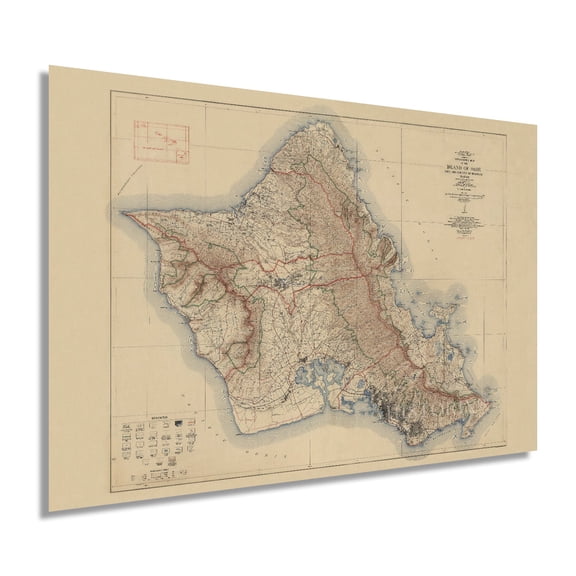
1938 Island of Oahu Map - Oahu Hawaii Vintage Map Wall Art - Topographic Map of the Island of Oahu Poster - City and County of Honolulu Hawaii - Oahu Print From $39.99
2 options
Available in additional 2 optionsFrom$3999
1938 Island of Oahu Map - Oahu Hawaii Vintage Map Wall Art - Topographic Map of the Island of Oahu Poster - City and County of Honolulu Hawaii - Oahu Print
Map of Honolulu, Hawaii, Multiline Coordinates Colored (18x24) From $16.95

3 options
Available in additional 3 optionsFrom$1695
Map of Honolulu, Hawaii, Multiline Coordinates Colored (18x24)
Hawaiian Islands - Pearl Harbor Honolulu - Vintage Map by J. Martin Miller c.1899 - Master Art Print (Unframed) 9in x 12in From $14.98

19 options
Available in additional 19 optionsFrom$1498
Hawaiian Islands - Pearl Harbor Honolulu - Vintage Map by J. Martin Miller c.1899 - Master Art Print (Unframed) 9in x 12in
1887 Honolulu Hawaii Map Poster - Vintage Map of Honolulu Wall Art - Old Honolulu Map - Historic Honolulu HI and Vicinity Showing Drainage and Public Buildings From $39.99

2 options
Available in additional 2 optionsFrom$3999
1887 Honolulu Hawaii Map Poster - Vintage Map of Honolulu Wall Art - Old Honolulu Map - Historic Honolulu HI and Vicinity Showing Drainage and Public Buildings
Other options to consider(452)
Hawaiian Islands - Sandwich Islands - Harbor of Honolulu - Vintage Colored Cartographic Map c.1899 - Fine Art Matte Paper Print (Unframed) 11x14in From $14.98

20 options
Available in additional 20 optionsFrom$1498
Hawaiian Islands - Sandwich Islands - Harbor of Honolulu - Vintage Colored Cartographic Map c.1899 - Fine Art Matte Paper Print (Unframed) 11x14in
Historic City Map - Honolulu Hawaii - Wall 1887 - Vintage Wall Art From $36.95

2 options
Available in additional 2 optionsFrom$3695
Historic City Map - Honolulu Hawaii - Wall 1887 - Vintage Wall Art
Historic County Map - Oahu County Hawaii - Beasley 1899 - Vintage Wall Art From $36.95

2 options
Available in additional 2 optionsFrom$3695
Historic County Map - Oahu County Hawaii - Beasley 1899 - Vintage Wall Art
Historic Print, U.S. Naval Base, Pearl Harbor, Naval Housing Area Makalapa, Angle Three-Bedroom Duplex Type M, Kamakani & Samoa Places, & Makalapa Drive, Pearl City, Honolulu County, HI - 4, 16" x 20" From $57.00

2 options
Available in additional 2 optionsFrom$5700
Historic Print, U.S. Naval Base, Pearl Harbor, Naval Housing Area Makalapa, Angle Three-Bedroom Duplex Type M, Kamakani & Samoa Places, & Makalapa Drive, Pearl City, Honolulu County, HI - 4, 16" x 20"
Historic Print, U.S. Naval Base, Pearl Harbor, Naval Housing Area Makalapa, Angle Three-Bedroom Duplex Type M, Kamakani & Samoa Places, & Makalapa Drive, Pearl City, Honolulu County, HI - 9, 18" x 24"

Historic Print, U.S. Naval Base, Pearl Harbor, Naval Housing Area Makalapa, Angle Three-Bedroom Duplex Type M, Kamakani & Samoa Places, & Makalapa Drive, Pearl City, Honolulu County, HI - 9, 18" x 24"
Historic County Map - Oahu County Hawaii - Covington 1881 - Vintage Wall Art From $36.95

2 options
Available in additional 2 optionsFrom$3695
Historic County Map - Oahu County Hawaii - Covington 1881 - Vintage Wall Art
Historic Print, U.S. Naval Base, Pearl Harbor, Naval Housing Area Makalapa, Angle Three-Bedroom Duplex Type M, Kamakani & Samoa Places, & Makalapa Drive, Pearl City, Honolulu County, HI - 2, 18" x 24"

Historic Print, U.S. Naval Base, Pearl Harbor, Naval Housing Area Makalapa, Angle Three-Bedroom Duplex Type M, Kamakani & Samoa Places, & Makalapa Drive, Pearl City, Honolulu County, HI - 2, 18" x 24"
Historic Print, U.S. Naval Base, Pearl Harbor, Naval Housing Area Makalapa, Angle Three-Bedroom Duplex Type M, Kamakani & Samoa Places, & Makalapa Drive, Pearl City, Honolulu County, HI - 3, 18" x 24"

Historic Print, U.S. Naval Base, Pearl Harbor, Naval Housing Area Makalapa, Angle Three-Bedroom Duplex Type M, Kamakani & Samoa Places, & Makalapa Drive, Pearl City, Honolulu County, HI - 3, 18" x 24"
Historic Print, U.S. Naval Base, Pearl Harbor, Naval Housing Area Makalapa, Angle Three-Bedroom Duplex Type M, Kamakani & Samoa Places, & Makalapa Drive, Pearl City, Honolulu County, HI - 5, 16" x 20"

Historic Print, U.S. Naval Base, Pearl Harbor, Naval Housing Area Makalapa, Angle Three-Bedroom Duplex Type M, Kamakani & Samoa Places, & Makalapa Drive, Pearl City, Honolulu County, HI - 5, 16" x 20"
Historic County Map - Haleakala Maui County Hawaii - US 1841 - Vintage Wall Art From $36.95

2 options
Available in additional 2 optionsFrom$3695
Historic County Map - Haleakala Maui County Hawaii - US 1841 - Vintage Wall Art
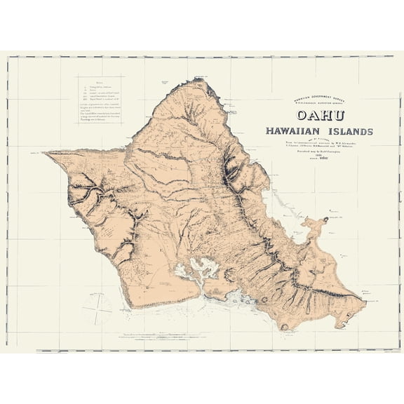
Historic County Map - Oahu County Hawaii - Alexander 1873 - Vintage Wall Art From $36.95

2 options
Available in additional 2 optionsFrom$3695
Historic County Map - Oahu County Hawaii - Alexander 1873 - Vintage Wall Art
Historic County Map - Pearl River Oahu County Hawaii - Sands 1873 - Vintage Wall Art From $36.95

2 options
Available in additional 2 optionsFrom$3695
Historic County Map - Pearl River Oahu County Hawaii - Sands 1873 - Vintage Wall Art
Historic Print, Iolani Barracks, Richards & Hotel Streets, Honolulu, Honolulu County, HI - 10, 18" x 24"

Historic Print, Iolani Barracks, Richards & Hotel Streets, Honolulu, Honolulu County, HI - 10, 18" x 24"
Historic County Map - Oahu County Hawaii - Covington 1881 - Vintage Wall Art From $36.95
2 options
Available in additional 2 optionsFrom$3695
Historic County Map - Oahu County Hawaii - Covington 1881 - Vintage Wall Art
Historic Print, Hawai'i State Capitol, Beretania and Punchbowl Streets, Honolulu, Honolulu County, HI - 5, 16" x 20"

Historic Print, Hawai'i State Capitol, Beretania and Punchbowl Streets, Honolulu, Honolulu County, HI - 5, 16" x 20"
Historic Print, Hawai'i State Capitol, Beretania and Punchbowl Streets, Honolulu, Honolulu County, HI - 4, 16" x 20"

Historic Print, Hawai'i State Capitol, Beretania and Punchbowl Streets, Honolulu, Honolulu County, HI - 4, 16" x 20"
Historic Print, Hawai'i State Capitol, Beretania and Punchbowl Streets, Honolulu, Honolulu County, HI - 2, 16" x 20" From $57.00

2 options
Available in additional 2 optionsFrom$5700
Historic Print, Hawai'i State Capitol, Beretania and Punchbowl Streets, Honolulu, Honolulu County, HI - 2, 16" x 20"
Historic Print, U.S. Naval Base, Pearl Harbor, Bombproof Facilities, Various locations throughout base, Pearl Harbor, Honolulu County, HI - 3, 18" x 24"

Historic Print, U.S. Naval Base, Pearl Harbor, Bombproof Facilities, Various locations throughout base, Pearl Harbor, Honolulu County, HI - 3, 18" x 24"
Historic Print, Iolani Palace, King & Richards Streets, Honolulu, Honolulu County, HI - 12, 18" x 24" From $57.00

2 options
Available in additional 2 optionsFrom$5700
Historic Print, Iolani Palace, King & Richards Streets, Honolulu, Honolulu County, HI - 12, 18" x 24"
Historic Print, Iolani Palace, King & Richards Streets, Honolulu, Honolulu County, HI - 51, 18" x 24" From $57.00

2 options
Available in additional 2 optionsFrom$5700
Historic Print, Iolani Palace, King & Richards Streets, Honolulu, Honolulu County, HI - 51, 18" x 24"
Historic Print, Iolani Barracks, Richards & Hotel Streets, Honolulu, Honolulu County, HI, 16" x 20" From $57.00

2 options
Available in additional 2 optionsFrom$5700
Historic Print, Iolani Barracks, Richards & Hotel Streets, Honolulu, Honolulu County, HI, 16" x 20"
Historic Print, Iolani Barracks, Richards & Hotel Streets, Honolulu, Honolulu County, HI - 12, 18" x 24"

Historic Print, Iolani Barracks, Richards & Hotel Streets, Honolulu, Honolulu County, HI - 12, 18" x 24"
Historic Print, Iolani Palace, King & Richards Streets, Honolulu, Honolulu County, HI - 8, 18" x 24" From $57.00

2 options
Available in additional 2 optionsFrom$5700
Historic Print, Iolani Palace, King & Richards Streets, Honolulu, Honolulu County, HI - 8, 18" x 24"
Historic Print, Iolani Palace, King & Richards Streets, Honolulu, Honolulu County, HI - 35, 18" x 24"

Historic Print, Iolani Palace, King & Richards Streets, Honolulu, Honolulu County, HI - 35, 18" x 24"
Historic Print, La Pietra, Poni Moi Road, Diamond Head, Honolulu, Honolulu County, HI - 5, 16" x 20"

Historic Print, La Pietra, Poni Moi Road, Diamond Head, Honolulu, Honolulu County, HI - 5, 16" x 20"
Historic Print, Iolani Barracks, Richards & Hotel Streets, Honolulu, Honolulu County, HI - 8, 16" x 20" From $57.00

2 options
Available in additional 2 optionsFrom$5700
Historic Print, Iolani Barracks, Richards & Hotel Streets, Honolulu, Honolulu County, HI - 8, 16" x 20"
Historic Print, La Pietra, Poni Moi Road, Diamond Head, Honolulu, Honolulu County, HI - 2, 18" x 24"

Historic Print, La Pietra, Poni Moi Road, Diamond Head, Honolulu, Honolulu County, HI - 2, 18" x 24"
Historic Print, La Pietra, Poni Moi Road, Diamond Head, Honolulu, Honolulu County, HI - 7, 18" x 24"

Historic Print, La Pietra, Poni Moi Road, Diamond Head, Honolulu, Honolulu County, HI - 7, 18" x 24"
Historic Print, Iolani Palace, King & Richards Streets, Honolulu, Honolulu County, HI - 14, 18" x 24" From $57.00

2 options
Available in additional 2 optionsFrom$5700
Historic Print, Iolani Palace, King & Richards Streets, Honolulu, Honolulu County, HI - 14, 18" x 24"
Historic Print, La Pietra, Poni Moi Road, Diamond Head, Honolulu, Honolulu County, HI - 9, 18" x 24" From $57.00

2 options
Available in additional 2 optionsFrom$5700
Historic Print, La Pietra, Poni Moi Road, Diamond Head, Honolulu, Honolulu County, HI - 9, 18" x 24"
Historic Print, La Pietra, Poni Moi Road, Diamond Head, Honolulu, Honolulu County, HI - 6, 18" x 24"

Historic Print, La Pietra, Poni Moi Road, Diamond Head, Honolulu, Honolulu County, HI - 6, 18" x 24"
Historic Print, Queen Emma's Summer Palace, 2913 Pali Highway, Honolulu, Honolulu County, HI - 2, 18" x 24" From $57.00

2 options
Available in additional 2 optionsFrom$5700
Historic Print, Queen Emma's Summer Palace, 2913 Pali Highway, Honolulu, Honolulu County, HI - 2, 18" x 24"
Historic Print, Iolani Palace, King & Richards Streets, Honolulu, Honolulu County, HI - 47, 18" x 24" From $57.00

2 options
Available in additional 2 optionsFrom$5700
Historic Print, Iolani Palace, King & Richards Streets, Honolulu, Honolulu County, HI - 47, 18" x 24"
Historic Print, Iolani Palace, King & Richards Streets, Honolulu, Honolulu County, HI - 13, 18" x 24"

Historic Print, Iolani Palace, King & Richards Streets, Honolulu, Honolulu County, HI - 13, 18" x 24"
Historic Print, Iolani Palace, King & Richards Streets, Honolulu, Honolulu County, HI - 36, 18" x 24"

Historic Print, Iolani Palace, King & Richards Streets, Honolulu, Honolulu County, HI - 36, 18" x 24"
Historic Print, Iolani Barracks, Richards & Hotel Streets, Honolulu, Honolulu County, HI - 15, 16" x 20"

Historic Print, Iolani Barracks, Richards & Hotel Streets, Honolulu, Honolulu County, HI - 15, 16" x 20"
Popular in Honolulu County Map
Related Products
Historic Map - Battersea London England - Philip 1904 - Vintage Wall Art
 Historic Map - Battersea London England - Philip 1904 - Vintage Wall Art$45.95current price $45.95
Historic State Map - Hawaii - Hammond 1910 - Vintage Wall Art
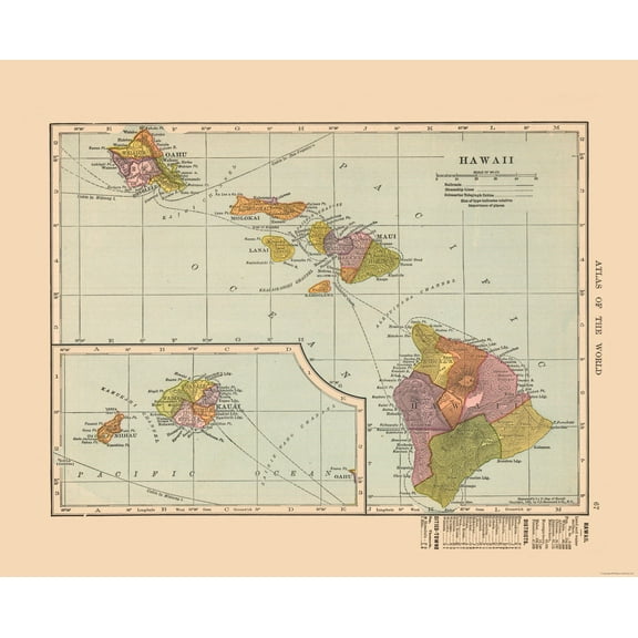 Historic State Map - Hawaii - Hammond 1910 - Vintage Wall Art$40.95current price $40.95
Bloom Theory Mauritius Poster Wall Art, Modern Wall Decor, 8x12 UNFRAMED
 Bloom Theory Mauritius Poster Wall Art, Modern Wall Decor, 8x12 UNFRAMED$19.49current price $19.49
Fiji Map, Fiji Map Print, Fiji Wall Art, Fiji Travel Poster, Fiji Poster, Fiji Photo, Fiji City Map, Fiji Island, Suva Fiji Poster Wall Art, Modern Wall Decor, 12x18 UNFRAMED
 Fiji Map, Fiji Map Print, Fiji Wall Art, Fiji Travel Poster, Fiji Poster, Fiji Photo, Fiji City Map, Fiji Island, Suva Fiji Poster Wall Art, Modern Wall Decor, 12x18 UNFRAMED$24.99current price $24.99
24"x36" Gallery Poster, birdseye view map of Bedford City, Virginia 1891
 24"x36" Gallery Poster, birdseye view map of Bedford City, Virginia 1891$52.95current price $52.95
Travel Poster of Bali, Travel Print of Bali, Indonesia, Travel Poster, Bali Print, 16x24 UNFRAMED
 Travel Poster of Bali, Travel Print of Bali, Indonesia, Travel Poster, Bali Print, 16x24 UNFRAMED$28.49current price $28.49
Vintage 1893 Map of Hawaii Wall Art Featuring the Hawaiian Islands with Historical Text and Statistical Data
 Vintage 1893 Map of Hawaii Wall Art Featuring the Hawaiian Islands with Historical Text and Statistical Data$17.51current price $17.51
Historic State Map - Rhode Island - Alden 1886 - Vintage Wall Art
 Historic State Map - Rhode Island - Alden 1886 - Vintage Wall Art$40.95current price $40.95
Palmetto Posters Large Detailed Political Map of Virgin Islands 20'' x 24'' Poster
Palmetto Posters Large Detailed Political Map of Virgin Islands 20'' x 24'' Poster
Historic City Map - Portland Maine - Cram 1892 - Vintage Wall Art
 Historic City Map - Portland Maine - Cram 1892 - Vintage Wall Art$45.95current price $45.95
Historic Map - Tasmania Australia - Cram 1892 - Vintage Wall Art
 Historic Map - Tasmania Australia - Cram 1892 - Vintage Wall Art$45.95current price $45.95
Historic State Map - Florida - Cram 1892 - Vintage Wall Art
 Historic State Map - Florida - Cram 1892 - Vintage Wall Art$40.95current price $40.95
Sequoia & Kings Canyon National Parks Hand-Drawn Map - Authentic 18x24 Vintage-Style Wall Art - Lithographic Print with Soy-Based Inks - Made in USA
 Sequoia & Kings Canyon National Parks Hand-Drawn Map - Authentic 18x24 Vintage-Style Wall Art - Lithographic Print with Soy-Based Inks - Made in USA$27.73current price $27.73
Topographical Map - Tupper Lake New York Quad - USGS 1907 - Vintage Wall Art
 Topographical Map - Tupper Lake New York Quad - USGS 1907 - Vintage Wall Art$45.95current price $45.95
Historic City Map - Portland Maine - Cram 1892 - Vintage Wall Art
Historic City Map - Portland Maine - Cram 1892 - Vintage Wall Art$40.95current price $40.95Historic Map - West Midlands England - Bartholomew 1892 - Vintage Wall Art
 Historic Map - West Midlands England - Bartholomew 1892 - Vintage Wall Art$45.95current price $45.95
Historic State Map - Florida - Cram 1892 - Vintage Wall Art
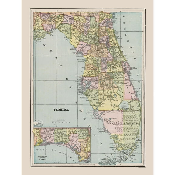 Historic State Map - Florida - Cram 1892 - Vintage Wall Art$45.95current price $45.95
Historic Map - Tasmania Figi Islands New Zealand - Rand McNally 1897 - Vintage Wall Art
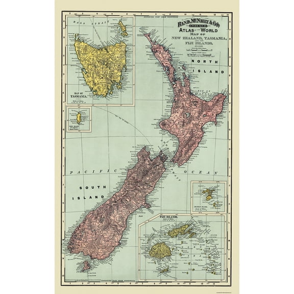 Historic Map - Tasmania Figi Islands New Zealand - Rand McNally 1897 - Vintage Wall Art$45.95current price $45.95