Hero image 0 of Historic City Map - Watertown Massachusetts - Whiting 1850 - 28.27 x 23 - Vintage Wall Art, 0 of 5
Historic City Map - Watertown Massachusetts - Whiting 1850 - 28.27 x 23 - Vintage Wall Art
(No ratings yet)
Key item features
- HISTORICAL LOCAL MAPS MAKE GREAT WALL ART - Ever wonder what your country looked like during the early days of the USA? Well now you can find out! Maps of the Past provides maps from various time periods so you can track the history of your local city or town. These gorgiously detailed maps make for a great piece of art for your home or office. Own a piece of art and history today!
- LOCAL MAPS PROVIDE IMPORTANT INFORMATION - Local maps show you how the borders of a local are established and were they can be found. It also highlights rivers, mountains, and other natural element you may not know are there. Local maps can also show you transportation lanes across your local
- ONLY ACCEPT THE BEST PRINT QUALITY FOR YOUR REPRODUCTIONS - There are many printers and print types available on the market, when purchasing a reproduction there is no finer quality reproduction than a reproduction using the Giclee Printing method. Giclee describes the technique or style of printing used, and it is revered as the highest quality printing because of the way it precisely sprays ink onto a surface. Trust nothing less than the best!
- GUARNANTEED TO GET EXACTLY WHAT YOU ORDERED - This map comes exactly to the specification of 23.00 x 28.27 inches/58.42 X 71.80 cm. All of our maps come rolled, wrapped, and shipped in a heavy gauge mailing tube to ensure it arrives intact.
- WHY CHOOSE MAPS OF THE PAST? - Maps of the Past is one of the single largest producers of different types of maps. They legally own the rights to the maps they sell, and provide them to you in clean, clear, and vibrant print. If you are looking for a high quality map print, then look no further than Maps of the Past!
Specs
- Size23.00 x 28.27
- MaterialGlossy Satin Photo Quality
- Decor styleVintage
- ThemeHistorical City Maps
- ShapeRectangle
- Art typePainting
Current price is USD$40.95$40.95/count
Price when purchased online
- Free shipping
 Free 30-day returns
How do you want your item?
Columbus, 43215
Arrives between Feb 28 - Mar 2
|Sold and shipped by Maps of the Past
4.3 stars out of 5, based on 10 seller reviews(4.3)10 seller reviews
Free 30-day returns
Check out these related products
Historic Map - Winnipeg Canada - White 1906 - 30.69 x 23 - Vintage Wall Art $40.95
 3 optionsAvailable in additional 3 options$4095current price $40.95
Historic Map - Winnipeg Canada - White 1906 - 30.69 x 23 - Vintage Wall Art
Historic Map - Vancouver Canada - White 1906 - 37.19 x 23 - Vintage Wall Art $40.95
 $4095current price $40.95
Historic Map - Vancouver Canada - White 1906 - 37.19 x 23 - Vintage Wall Art
Historic Map - Quebec Canada - White 1906 - 27.05 x 23 - Vintage Wall Art $40.95
 $4095current price $40.95
Historic Map - Quebec Canada - White 1906 - 27.05 x 23 - Vintage Wall Art
Historic Map - Ottawa Canada - White 1906 - 27.28 x 23 - Vintage Wall Art $40.95
 3 optionsAvailable in additional 3 options$4095current price $40.95
Historic Map - Ottawa Canada - White 1906 - 27.28 x 23 - Vintage Wall Art
Historic Map - Manitoba Saskatchewan Canada - White 1906 - 31.78 x 23 - Vintage Wall Art $40.95 $40.95/count
 $4095current price $40.95$40.95/count
Historic Map - Manitoba Saskatchewan Canada - White 1906 - 31.78 x 23 - Vintage Wall Art
Historic Map - Manitoba Saskatchewan Canada - White 1906 - 31.68 x 23 - Vintage Wall Art $40.95
 $4095current price $40.95
Historic Map - Manitoba Saskatchewan Canada - White 1906 - 31.68 x 23 - Vintage Wall Art
Historic Map - Montreal Canada - White 1906 - 27.96 x 23 - Vintage Wall Art $40.95
 $4095current price $40.95
Historic Map - Montreal Canada - White 1906 - 27.96 x 23 - Vintage Wall Art
Historic Map - Asia 18th Century End - Spruner 1855 - 28.84 x 23 - Vintage Wall Art $40.95
 $4095current price $40.95
Historic Map - Asia 18th Century End - Spruner 1855 - 28.84 x 23 - Vintage Wall Art
Historic Map - Toronto Canada - White 1906 - 33.03 x 23 - Vintage Wall Art $40.95
 $4095current price $40.95
Historic Map - Toronto Canada - White 1906 - 33.03 x 23 - Vintage Wall Art
Historic City Map - Beaumont Texas - White 1902 - 23 x 31.19 - Vintage Wall Art $40.95
 3 optionsAvailable in additional 3 options$4095current price $40.95
Historic City Map - Beaumont Texas - White 1902 - 23 x 31.19 - Vintage Wall Art
Historic City Map - Chicago Illinois - Cram 1892 - 23 x 27.85 - Vintage Wall Art $40.95
 3 optionsAvailable in additional 3 options$4095current price $40.95
Historic City Map - Chicago Illinois - Cram 1892 - 23 x 27.85 - Vintage Wall Art
Topographical Map - Alamorio Sheet - US Army 1944 - 23 x 30.75 - Vintage Wall Art $40.95 $40.95/count
 $4095current price $40.95$40.95/count
Topographical Map - Alamorio Sheet - US Army 1944 - 23 x 30.75 - Vintage Wall Art
Topographical Map - Plaster City Sheet - US Army 1944 - 23 x 30.71 - Vintage Wall Art $40.95
 3 optionsAvailable in additional 3 options$4095current price $40.95
Topographical Map - Plaster City Sheet - US Army 1944 - 23 x 30.71 - Vintage Wall Art
Topographical Map - Brawley Sheet - US Army 1944 - 23 x 30.79 - Vintage Wall Art $40.95 $40.95/count
 $4095current price $40.95$40.95/count
Topographical Map - Brawley Sheet - US Army 1944 - 23 x 30.79 - Vintage Wall Art
Topographical Map - Kelseyville Sheet - US Army 1944 - 23 x 30.59 - Vintage Wall Art $40.95
 $4095current price $40.95
Topographical Map - Kelseyville Sheet - US Army 1944 - 23 x 30.59 - Vintage Wall Art
Topographical Map - Castle Butte Sheet - US Army 1943 - 23 x 30.37 - Vintage Wall Art $40.95 $40.95/count
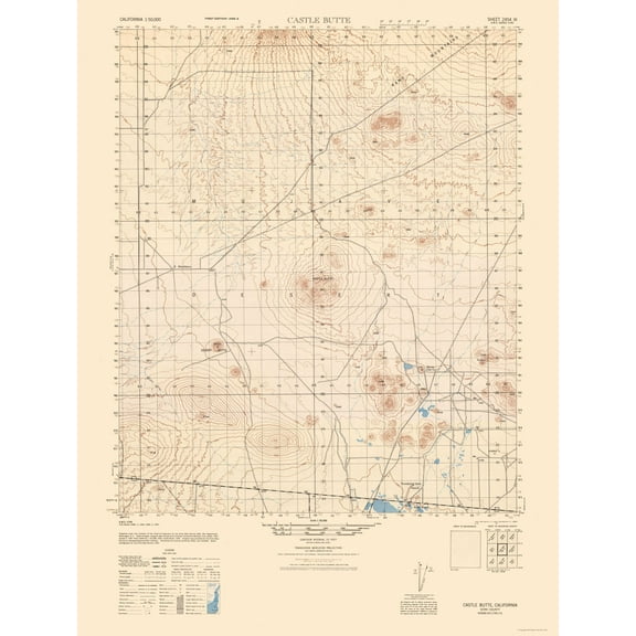 $4095current price $40.95$40.95/count
Topographical Map - Castle Butte Sheet - US Army 1943 - 23 x 30.37 - Vintage Wall Art
Topographical Map - Frink Sheet - US Army 1944 - 23 x 31.47 - Vintage Wall Art $40.95 $40.95/count
 $4095current price $40.95$40.95/count
Topographical Map - Frink Sheet - US Army 1944 - 23 x 31.47 - Vintage Wall Art
Topographical Map - Midland Sheet - US Army 1945 - 23 x 30.79 - Vintage Wall Art $40.95
 3 optionsAvailable in additional 3 options$4095current price $40.95
Topographical Map - Midland Sheet - US Army 1945 - 23 x 30.79 - Vintage Wall Art
Historic Map - Greece Turkey Aegaean Sea Coasts Islands - Oxford 1828 - 23 x 32.83 - Vintage Wall Art $40.95
 $4095current price $40.95
Historic Map - Greece Turkey Aegaean Sea Coasts Islands - Oxford 1828 - 23 x 32.83 - Vintage Wall Art
Historic Map - Central Asia - Oxford 1828 - 31.83 x 23 - Vintage Wall Art $40.95 $40.95/count
 $4095current price $40.95$40.95/count
Historic Map - Central Asia - Oxford 1828 - 31.83 x 23 - Vintage Wall Art
About this item
Product details
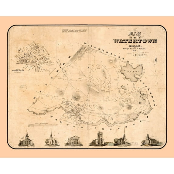
Historic City Maps - Watertown Massachusetts - Whiting 1850 - This is an exquisite full-color Reproduction printed on high-quality gloss paper, art paper or canvas.
Print Size: 23.00 x 28.27 inches
58.42 X 71.80cm
The following towns are featured: Watertown.
This Map is Situated in: Watertown.
SKU: MAWA0001
Original Maps are often difficult to find and usually have fold lines, identifying stamps or markings, tears, ragged edges, and assorted other natural signs of age that detract from their beauty. All of our maps have been professionally restored to depict their original beauty, while keeping all historical data intact.
These maps are fabulous pieces of history full of information useful to Historians, Genealogists, Cartographers, Relic Hunters, & Others. They make fascinating conversation pieces and splendid works of art for the home or office.
- HISTORICAL LOCAL MAPS MAKE GREAT WALL ART - Ever wonder what your country looked like during the early days of the USA? Well now you can find out! Maps of the Past provides maps from various time periods so you can track the history of your local city or town. These gorgiously detailed maps make for a great piece of art for your home or office. Own a piece of art and history today!
- LOCAL MAPS PROVIDE IMPORTANT INFORMATION - Local maps show you how the borders of a local are established and were they can be found. It also highlights rivers, mountains, and other natural element you may not know are there. Local maps can also show you transportation lanes across your local
- ONLY ACCEPT THE BEST PRINT QUALITY FOR YOUR REPRODUCTIONS - There are many printers and print types available on the market, when purchasing a reproduction there is no finer quality reproduction than a reproduction using the Giclee Printing method. Giclee describes the technique or style of printing used, and it is revered as the highest quality printing because of the way it precisely sprays ink onto a surface. Trust nothing less than the best!
- GUARNANTEED TO GET EXACTLY WHAT YOU ORDERED - This map comes exactly to the specification of 23.00 x 28.27 inches/58.42 X 71.80 cm. All of our maps come rolled, wrapped, and shipped in a heavy gauge mailing tube to ensure it arrives intact.
- WHY CHOOSE MAPS OF THE PAST? - Maps of the Past is one of the single largest producers of different types of maps. They legally own the rights to the maps they sell, and provide them to you in clean, clear, and vibrant print. If you are looking for a high quality map print, then look no further than Maps of the Past!
info:
We aim to show you accurate product information. Manufacturers, suppliers and others provide what you see here, and we have not verified it.
Specifications
Size
23.00 x 28.27
Material
Glossy Satin Photo Quality
Decor style
Vintage
Theme
Historical City Maps
Warranty
Warranty information
Please be aware that the warranty terms on items offered for sale by third party Marketplace sellers may differ from those displayed in this section (if any). To confirm warranty terms on an item offered for sale by a third party Marketplace seller, please use the 'Contact seller' feature on the third party Marketplace seller's information page and request the item's warranty terms prior to purchase.
Customer ratings & reviews
0 ratings|0 reviews
This item does not have any reviews yet

Related pages
- Mines Nevada Map
- Mount Rainier Map
- Galveston Map
- Jacksonville Map
- Menomonee Falls Map
- Glacier Bay Map
- National Parks Posters
- Central America Travel Books, Maps & Guides
- Cyprus Travel Books
- Caribbean & West Indies Travel Books, Maps & Guides
- Ontario Travel Books, Maps & Guides
- General South America Travel Books, Maps & Guides