Hero image 0 of Topographical Map - Lake Itasca North Dakota South Dakota Sheet - USAF 1961 - 23 x 30 - Vintage Wall Art, 0 of 5
Topographical Map - Lake Itasca North Dakota South Dakota Sheet - USAF 1961 - 23 x 30 - Vintage Wall Art
(No ratings yet)
Topographical Map - Lake Itasca North Dakota South Dakota Sheet - USAF 1961 - 23 x 30 - Vintage Wall ArtTopographical Map Lake Itasca North Dakota South Dakota Sheet USAF 1961 23 x 30 Vintage Wall ArtTopographical Map Lake Itasca North Dakota South Dakota Sheet USAF 1961 23 x 30 Vintage Wall ArtTopographical Map Lake Itasca North Dakota South Dakota Sheet USAF 1961 23 x 30 Vintage Wall Art
Material:Glossy Satin Photo Quality
Key item features
- OWN A HISTORICAL TOPOGRAPHICAL MAP TODAY - Topographical maps provide you a birds-eye view of how the topography of certain pieces of land are mapped out. See how much today's maps have changed from centuries ago. See how waterways have shifted, or how forrests have become thralling cities. See how history has changed the landscape with a topographical map today!
- TOPOGRAPHICAL MAPS PROVIDE IMPORTANT INFORMATION -Topographical maps show you how the borders of a county are established and were they can be found. It also highlights rivers, mountains, and other natural elements, and it will show you where the cities are located within it.
- ONLY ACCEPT THE BEST PRINT QUALITY FOR YOUR REPRODUCTIONS - There are many printers and print types available on the market, when purchasing a reproduction there is no finer quality reproduction than a reproduction using the Giclee Printing method. Giclee describes the technique or style of printing used, and it is revered as the highest quality printing because of the way it precisely sprays ink onto a surface. Trust nothing less than the best!
- GUARNANTEED TO GET EXACTLY WHAT YOU ORDERED - This map comes exactly to the specification of 23.00 x 30.11 inches/58.42 X 76.47 cm. All of our maps come rolled, wrapped, and shipped in a heavy gauge mailing tube to ensure it arrives intact.
- WHY CHOOSE MAPS OF THE PAST? - Maps of the Past is one of the single largest producers of different types of maps. They legally own the rights to the maps they sell, and provide them to you in clean, clear, and vibrant print. If you are looking for a high quality map print, then look no further than Maps of the Past!
Specs
- Size23.00 x 30.11
- MaterialGlossy Satin Photo Quality
- Decor styleVintage
- ThemeHistoric Topographic Maps
- ShapeRectangle
- Art typePainting
Current price is USD$36.95$36.95/count
Price when purchased online
- Free shipping
 Free 30-day returns
How do you want your item?
Columbus, 43215
Arrives between Feb 9 - Feb 11
|Sold and shipped by Maps of the Past
4.3 stars out of 5, based on 10 seller reviews(4.3)10 seller reviews
Free 30-day returns
Popular items in this category
Best selling items that customers love
Map of Florida 1855 Art Print - 11x14 Unframed Art Print - Great Vintage Home Decor $14.99
 $1499current price $14.99
Map of Florida 1855 Art Print - 11x14 Unframed Art Print - Great Vintage Home Decor
Shipping, arrives in 3+ daysRivers Edge Products Canvas Wall Art, Licensed Art by Victoria Wilson-Schultz, Country Wild West Western Decor for Bedroom Home Office and Living Room Wall Decor, 12 Inch x 16 Inch, Cowboy $14.99
 7 optionsAvailable in additional 7 options$1499current price $14.99
Rivers Edge Products Canvas Wall Art, Licensed Art by Victoria Wilson-Schultz, Country Wild West Western Decor for Bedroom Home Office and Living Room Wall Decor, 12 Inch x 16 Inch, Cowboy
Shipping, arrives in 3+ daysNew York Subway Map 1948 Art Print - 11x14 Unframed Art Print - Great Vintage Home Decor $14.99
 $1499current price $14.99
New York Subway Map 1948 Art Print - 11x14 Unframed Art Print - Great Vintage Home Decor
Shipping, arrives in 3+ days48x78 Huge United States, USA Contemporary Elite Wall Map Laminated $44.00
 3 optionsAvailable in additional 3 options$4400current price $44.00More options from $18.90
48x78 Huge United States, USA Contemporary Elite Wall Map Laminated
114.1 out of 5 Stars. 11 reviewsShipping, arrives in 3+ daysTexas Map Houston and Texas Central Railroad Art Print - 11x14 Unframed Art Print - Great Vintage Home Decor $14.99
 $1499current price $14.99
Texas Map Houston and Texas Central Railroad Art Print - 11x14 Unframed Art Print - Great Vintage Home Decor
Shipping, arrives in 3+ days24x36 United States, USA Classic Elite Wall Map Mural Poster $21.90
 3 optionsAvailable in additional 3 options$2190current price $21.90More options from $12.99
24x36 United States, USA Classic Elite Wall Map Mural Poster
254.4 out of 5 Stars. 25 reviewsSave with Shipping, arrives in 2 days
HISTORIX 1862 United States Railroad and Military Map Vintage Poster Wall Art Print, 18 x 24 Inch $39.99
 2 optionsAvailable in additional 2 options$3999current price $39.99Options from $39.99 – $59.99
HISTORIX 1862 United States Railroad and Military Map Vintage Poster Wall Art Print, 18 x 24 Inch
Shipping, arrives in 3+ daysELITEART-Among the Sierra Nevada Mountains, California (1868), By Albert Bierstadt Oil Painting Reproduction Giclee Wall Art Canvas Prints-Framed Size:21" x 30" $132.49

 $13249current price $132.49
ELITEART-Among the Sierra Nevada Mountains, California (1868), By Albert Bierstadt Oil Painting Reproduction Giclee Wall Art Canvas Prints-Framed Size:21" x 30"
Shipping, arrives in 3+ daysTrademark Art 'Map of South America, 1700' Canvas Art by Guillaume Delisle $44.95
 4 optionsAvailable in additional 4 options$4495current price $44.95More options from $36.35
Trademark Art 'Map of South America, 1700' Canvas Art by Guillaume Delisle
Save withShipping, arrives tomorrow3 Panel Tree Canvas Wall Art Black and White Teal Tree with Full Moon Painting Pictures Prints Artwork for Living Room Bedroom Wall Decor Framed Ready to Hang $28.79

 $2879current price $28.79+$6.99 shipping
3 Panel Tree Canvas Wall Art Black and White Teal Tree with Full Moon Painting Pictures Prints Artwork for Living Room Bedroom Wall Decor Framed Ready to Hang
Shipping, arrives in 3+ daysTrademark Fine Art Masters Fine Art USA License Plate Map on Wood Canvas Wall Art - 14x19 $32.95
 4 optionsAvailable in additional 4 options$3295current price $32.95Options from $32.95 – $99.95
Trademark Fine Art Masters Fine Art USA License Plate Map on Wood Canvas Wall Art - 14x19
15 out of 5 Stars. 1 reviewsShipping, arrives in 3+ days1818 Map of Washington DC Art Print - 11x14 Unframed Art Print - Great Vintage Home Decor $14.99
 $1499current price $14.99
1818 Map of Washington DC Art Print - 11x14 Unframed Art Print - Great Vintage Home Decor
Shipping, arrives in 3+ days1938 Michigan Map Art Print - 11x14 Unframed Art Print - Great Vintage Home Decor $14.99
 $1499current price $14.99
1938 Michigan Map Art Print - 11x14 Unframed Art Print - Great Vintage Home Decor
1845 Michigan Map Art Print - 11x14 Unframed Art Print - Great Vintage Home Decor $14.99
 $1499current price $14.99
1845 Michigan Map Art Print - 11x14 Unframed Art Print - Great Vintage Home Decor
Shipping, arrives in 3+ daysNorthlight Patriotic “Proud to be an American” Wooden USA Map Wall Art - 15.75” x 12” $18.99
 $1899current price $18.99
Northlight Patriotic “Proud to be an American” Wooden USA Map Wall Art - 15.75” x 12”
Shipping, arrives in 3+ daysMadison Park Royal Cat Portrait Renaissance Style Framed Canvas Wall Art, King Charles, 16.5"W x 20.5"H $15.99
 6 optionsAvailable in additional 6 options$1599current price $15.99
Madison Park Royal Cat Portrait Renaissance Style Framed Canvas Wall Art, King Charles, 16.5"W x 20.5"H
304.9 out of 5 Stars. 30 reviewsSave withShipping, arrives in 2 daysGeoJango United States Wall Map Poster - Lite Terrain (24x16 Inches) $39.00
 3 optionsAvailable in additional 3 options$3900current price $39.00Options from $39.00 – $59.00
GeoJango United States Wall Map Poster - Lite Terrain (24x16 Inches)
Shipping, arrives in 3+ days
About this item
Product details
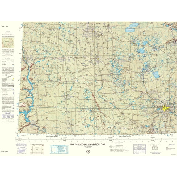
Topographical Map - Lake Itasca North Dakota, South Dakota 1961 - This is an exquisite full-color Reproduction printed on high-quality gloss paper, art paper or canvas.
Print Size: 23.00 x 30.11 inches
58.42 X 76.47cm
Sites and Townships Specific To This Map Are: Minneapolis, St. Paul, Mankato, Watertown, Fargo, Moorhead, Grand Forks, Bismarck and many more
The following towns are featured: The area surrounding Lake Itasca in North Dakota, South Dakota and Minnesota surveyed by and for the U.S. Air Force (USAF). This type of map focuses on elevation, bodies of water, roadways, navigation and aeronautical information. The entire concept of terrain illustration is based on regional studies to determine broad areas of different physiographic characteristics in order to capture the relative significance of ground forms. Features of note include: Minnesota River, Missouri River, Mississippi River, St. Croix River, Lake Ashtabula, Red Lake and Oahe Reservoir. Along the bottom of the map is an index of adjoining sheets and a series of distance scales; the map legend runs along the left side.
This Map is Situated in: States of North Dakota, South Dakota and Minnesota (ND/SD/MN)
SKU: MNLI0002
Original Maps are often difficult to find and usually have fold lines, identifying stamps or markings, tears, ragged edges, and assorted other natural signs of age that detract from their beauty. All of our maps have been professionally restored to depict their original beauty, while keeping all historical data intact.
These maps are fabulous pieces of history full of information useful to Historians, Genealogists, Cartographers, Relic Hunters, & Others. They make fascinating conversation pieces and splendid works of art for the home or office.
- OWN A HISTORICAL TOPOGRAPHICAL MAP TODAY - Topographical maps provide you a birds-eye view of how the topography of certain pieces of land are mapped out. See how much today's maps have changed from centuries ago. See how waterways have shifted, or how forrests have become thralling cities. See how history has changed the landscape with a topographical map today!
- TOPOGRAPHICAL MAPS PROVIDE IMPORTANT INFORMATION -Topographical maps show you how the borders of a county are established and were they can be found. It also highlights rivers, mountains, and other natural elements, and it will show you where the cities are located within it.
- ONLY ACCEPT THE BEST PRINT QUALITY FOR YOUR REPRODUCTIONS - There are many printers and print types available on the market, when purchasing a reproduction there is no finer quality reproduction than a reproduction using the Giclee Printing method. Giclee describes the technique or style of printing used, and it is revered as the highest quality printing because of the way it precisely sprays ink onto a surface. Trust nothing less than the best!
- GUARNANTEED TO GET EXACTLY WHAT YOU ORDERED - This map comes exactly to the specification of 23.00 x 30.11 inches/58.42 X 76.47 cm. All of our maps come rolled, wrapped, and shipped in a heavy gauge mailing tube to ensure it arrives intact.
- WHY CHOOSE MAPS OF THE PAST? - Maps of the Past is one of the single largest producers of different types of maps. They legally own the rights to the maps they sell, and provide them to you in clean, clear, and vibrant print. If you are looking for a high quality map print, then look no further than Maps of the Past!
info:
We aim to show you accurate product information. Manufacturers, suppliers and others provide what you see here, and we have not verified it.
Specifications
Size
23.00 x 30.11
Material
Glossy Satin Photo Quality
Decor style
Vintage
Theme
Historic Topographic Maps
Warranty
Warranty information
Please be aware that the warranty terms on items offered for sale by third party Marketplace sellers may differ from those displayed in this section (if any). To confirm warranty terms on an item offered for sale by a third party Marketplace seller, please use the 'Contact seller' feature on the third party Marketplace seller's information page and request the item's warranty terms prior to purchase.
Customer ratings & reviews
0 ratings|0 reviews
This item does not have any reviews yet

Related pages
- West Virginia Maps By County
- Akron Ohio Map
- Yosemite National Park Map California
- West Virginia Map
- Florida Map By County
- Kentucky Counties Map
- Central America Travel Books, Maps & Guides
- Northeast United States Travel Books, Maps & Guides
- General South America Travel Books, Maps & Guides
- National Parks Posters
- Midwest United States Travel Books, Maps & Guides
- Southern United States Travel Books, Maps & Guides