
Hero image 0 of Topographical Map - Colorado Sheet - McConnell 1894 - 23 x 32.08 - Vintage Wall Art, 0 of 5
Topographical Map - Colorado Sheet - McConnell 1894 - 23 x 32.08 - Vintage Wall Art
(No ratings yet)
Topographical Map - Colorado Sheet - McConnell 1894 - 23 x 32.08 - Vintage Wall ArtTopographical Map Colorado Sheet McConnell 1894 23 x 32 08 Vintage Wall ArtTopographical Map Colorado Sheet McConnell 1894 23 x 32 08 Vintage Wall ArtTopographical Map Colorado Sheet McConnell 1894 23 x 32 08 Vintage Wall Art
Material:Matte Art
Current price is USD$74.95$74.95/count
Price when purchased online
- Free shipping
- Free 30-day returns
Pro Wall Hanging Service
How do you want your item?
Columbus, 43215
Arrives between Feb 18 - Feb 21
|Sold and shipped by Maps of the Past
4.3 stars out of 5, based on 10 seller reviews(4.3)
Free 30-day returns
| Product | Viewing this item |
|---|

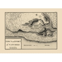


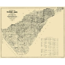
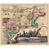

| Size | 23.00 x 32.08Topographical Map - Colorado Sheet - McConnell 1894 - 23 x 32.08 - Vintage Wall Art | 23.00 x 31.60Historic City Map - Natchez Mississippi - Collot 1796 - 23 x 31.60 - Vintage Wall Art | 23.00 x 25.21Historic City Map - Hardy Ohio - Cring 1875 - 23 x 25.21 - Vintage Wall Art | 23.00 x 29.50Historic State Map - Oregon - USGLO 1866 - 23 x 29.50 - Vintage Wall Art | 23.00 x 28.50Historic Map - Arabian Peninsula- Blaeu 1662 - 23 x 28.50 - Vintage Wall Art | 23 x 28.75Topographical Map - Big Trees California Quad - USGS 1901 - 23 x 28.75 - Vintage Wall Art | 23.00 x 33.05Historic Map - California Island - De Fer 1720 - 23 x 33.05 - Vintage Wall Art | 29 x 23Historic Mine Map - Calaveras County California Mines - Walkup 1845 - 29 x 23 - Vintage Wall Art | 26.63 x 23Historic State Map - America Septentrionali - 1751 - 26.63 x 23 - Vintage Wall Art | 23 x 27.06Historic State Map - Michigan - Greenleaf 1841 - 23 x 27.06 - Vintage Wall Art |
|---|---|---|---|---|---|---|---|---|---|---|
| Material | Matte ArtTopographical Map - Colorado Sheet - McConnell 1894 - 23 x 32.08 - Vintage Wall Art | Matte ArtHistoric City Map - Natchez Mississippi - Collot 1796 - 23 x 31.60 - Vintage Wall Art | Matte ArtHistoric City Map - Hardy Ohio - Cring 1875 - 23 x 25.21 - Vintage Wall Art | Matte ArtHistoric State Map - Oregon - USGLO 1866 - 23 x 29.50 - Vintage Wall Art | Matte ArtHistoric Map - Arabian Peninsula- Blaeu 1662 - 23 x 28.50 - Vintage Wall Art | Matte ArtTopographical Map - Big Trees California Quad - USGS 1901 - 23 x 28.75 - Vintage Wall Art | Matte ArtHistoric Map - California Island - De Fer 1720 - 23 x 33.05 - Vintage Wall Art | Matte ArtHistoric Mine Map - Calaveras County California Mines - Walkup 1845 - 29 x 23 - Vintage Wall Art | Matte ArtHistoric State Map - America Septentrionali - 1751 - 26.63 x 23 - Vintage Wall Art | Matte ArtHistoric State Map - Michigan - Greenleaf 1841 - 23 x 27.06 - Vintage Wall Art |
| Decor style | VintageTopographical Map - Colorado Sheet - McConnell 1894 - 23 x 32.08 - Vintage Wall Art | VintageHistoric City Map - Natchez Mississippi - Collot 1796 - 23 x 31.60 - Vintage Wall Art | VintageHistoric City Map - Hardy Ohio - Cring 1875 - 23 x 25.21 - Vintage Wall Art | VintageHistoric State Map - Oregon - USGLO 1866 - 23 x 29.50 - Vintage Wall Art | VintageHistoric Map - Arabian Peninsula- Blaeu 1662 - 23 x 28.50 - Vintage Wall Art | VintageTopographical Map - Big Trees California Quad - USGS 1901 - 23 x 28.75 - Vintage Wall Art | VintageHistoric Map - California Island - De Fer 1720 - 23 x 33.05 - Vintage Wall Art | VintageHistoric Mine Map - Calaveras County California Mines - Walkup 1845 - 29 x 23 - Vintage Wall Art | VintageHistoric State Map - America Septentrionali - 1751 - 26.63 x 23 - Vintage Wall Art | VintageHistoric State Map - Michigan - Greenleaf 1841 - 23 x 27.06 - Vintage Wall Art |
| Theme | Historic Topographic MapsTopographical Map - Colorado Sheet - McConnell 1894 - 23 x 32.08 - Vintage Wall Art | Historical City MapsHistoric City Map - Natchez Mississippi - Collot 1796 - 23 x 31.60 - Vintage Wall Art | Historical City MapsHistoric City Map - Hardy Ohio - Cring 1875 - 23 x 25.21 - Vintage Wall Art | Old State MapsHistoric State Map - Oregon - USGLO 1866 - 23 x 29.50 - Vintage Wall Art | -Historic Map - Arabian Peninsula- Blaeu 1662 - 23 x 28.50 - Vintage Wall Art | Historic Topographic MapsTopographical Map - Big Trees California Quad - USGS 1901 - 23 x 28.75 - Vintage Wall Art | -Historic Map - California Island - De Fer 1720 - 23 x 33.05 - Vintage Wall Art | Historical County MapsHistoric Mine Map - Calaveras County California Mines - Walkup 1845 - 29 x 23 - Vintage Wall Art | Old State MapsHistoric State Map - America Septentrionali - 1751 - 26.63 x 23 - Vintage Wall Art | Old State MapsHistoric State Map - Michigan - Greenleaf 1841 - 23 x 27.06 - Vintage Wall Art |
Now hiding additional rows in the Table
About this item


Customer ratings & reviews
0 ratings|0 reviews
This item does not have any reviews yet

Related pages
- Alabama County Map Roads
- Map Illinois Highways
- Florida Map By County
- Interstate Highways Map
- Missouri Map Counties
- Jersey Counties Map Cities
- Northeast United States Travel Books, Maps & Guides
- Southern United States Travel Books, Maps & Guides
- Central America Travel Books, Maps & Guides
- General United States Travel Books, Maps & Guides
- Rand McNally Travel Books, Maps & Guides
- Peru Travel Books, Maps & Guides