Sorry, this item is out of stock
Browse similar items
Big Sky Maps East Klickitat GMU Map 382 $14.97
 $1497current price $14.97
Big Sky Maps East Klickitat GMU Map 382
VIP Home and Garden Vintage New York Map Canvas Print Wall Hanging $26.35
 $2635current price $26.35
VIP Home and Garden Vintage New York Map Canvas Print Wall Hanging
Pensacola & Escambia Bays, FL $18.95
 $1895current price $18.95
Pensacola & Escambia Bays, FL
Metedeconk Neck to Surf City, NJ $19.95
 $1995current price $19.95
Metedeconk Neck to Surf City, NJ
2025 Vintage Color Map, United States Geography Poster, Mount McKinley Location, Educational Tool for Home or Office Décor, Highly Detailed Collectible Map $7.13
 $713current price $7.13+$3.99 shipping
2025 Vintage Color Map, United States Geography Poster, Mount McKinley Location, Educational Tool for Home or Office Décor, Highly Detailed Collectible Map
Estero to Lemon Bay, FL $27.95
 $2795current price $27.95
Estero to Lemon Bay, FL
Upper Neuse River, NC $18.95
 $1895current price $18.95
Upper Neuse River, NC
Top Spot Fishing Map N231, Panacea to Apalachee Bay Area Gulf Of Mexico $32.31
 $3231current price $32.31
Top Spot Fishing Map N231, Panacea to Apalachee Bay Area Gulf Of Mexico
Middle Chesapeake Bay $29.95
 $2995current price $29.95
Middle Chesapeake Bay
Inshore Cohasset to Manomet, MA $29.95
 $2995current price $29.95
Inshore Cohasset to Manomet, MA
Map of Asheville, North Carolina, Multiline Coordinates Colored (8x10) $16.95
 Options from$1695– $4995
Map of Asheville, North Carolina, Multiline Coordinates Colored (8x10)
Pinnacle Map Set - No Man's Land/Village New $15.53
 $1553current price $15.53
Pinnacle Map Set - No Man's Land/Village New
Franko Maps Caribbean Sea Reef Creatures Fish ID-Card $23.23
 $2323current price $23.23
Franko Maps Caribbean Sea Reef Creatures Fish ID-Card
Historic State Map - Vermont - Carey 1795 - 23 x 27.81 - Vintage Wall Art $36.95
 Options from$3695– $9495
Historic State Map - Vermont - Carey 1795 - 23 x 27.81 - Vintage Wall Art
Inshore Tampa Bay, FL $27.95
 $2795current price $27.95
Inshore Tampa Bay, FL
Inshore North Coast of New Jersey $29.95
 $2995current price $29.95
Inshore North Coast of New Jersey
Historical Civil War Map - Beaufort South Carolina - Schelten 1861 - 34.81 x 23 - Vintage Wall Art $36.95
 Options from$3695– $9495
Historical Civil War Map - Beaufort South Carolina - Schelten 1861 - 34.81 x 23 - Vintage Wall Art


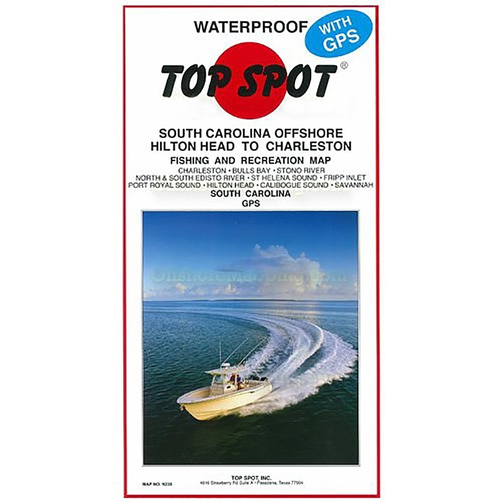
Top Spot Fishing Map N235, Hilton Head to Charleston Maps
(No ratings yet)
Key item features
- Comprehensive Coverage: Covers Hilton Head to Charleston, South Carolina, including Charleston, Bulls Bay, Stono River, North and South Edisto River, St. Helena Sound, Fripp Inlet, Port Royal Sound, Hilton Head, Calibogue Sound, and Savannah.
- Waterproof Design: The map is waterproof, making it durable and suitable for use in marine environments.
- Fishing and Diving: Designed for Atlantic Ocean fishing and diving recreation, providing detailed information for enthusiasts.
- Best Fishing Times: Includes information on the best fishing times to enhance your fishing experience.
- Detailed Information: Provides detailed information and GPS coordinates for fishing locations, boat ramps, marinas, and other points of interest.
- Full Color Map: Features a full-color design on both sides, enhancing readability and usability.
- Habitat and Structure: Highlights the best habitats and underwater structures for fishing.
Generated by AI
Specs
- Map typeFishing Map
- FeaturesWaterproof
- BrandTop Spot
- MaterialPaper
- ActivityOutdoor Activity
- ColorWhite
Current price is USD$25.99
Price when purchased online
Out of stock
How do you want your item?
Out of stock
About this item
Product details
Hilton Head to Charleston, South Carolina, Offshore. Top Spot Fishing Maps are waterproof and include best fishing times, the best habitats and underwater structure. Detailed information and GPS coordinates are provided for fishing locations, boat ramps, marinas and other points of interest. 2 sides, full color fishing and diving recreation map.
- Top Spot Map
- Hilton Head to Charleston, South Carolina Offshore. Charleston, Bulls Bay, Stono River, North and South Edisto River, St. Helena Sound, Fripp Inlet, Port Royal Sound, Hilton Head, Calibogue Sound, Savannah.
- Top Spot Map N-235, South Carolina Hilton Head to Charleston, South Carolina Offshore. Charleston, Bulls Bay, Stono River, North and South Edisto River, St. Helena Sound, Fripp Inlet, Port Royal Sound, Hilton Head, Calibogue Sound, Savannah. Atlantic Ocean Fishing and Diving Recreation Map.
-
- Top Spot Map N-235, South Carolina Hilton Head to Charleston, South Carolina Offshore. Charleston, Bulls Bay, Stono River, North and South Edisto River, St. Helena Sound, Fripp Inlet, Port Royal Sound, Hilton Head, Calibogue Sound, Savannah. Atlantic Ocean Fishing and Diving Recreation Map.
info:
We aim to show you accurate product information. Manufacturers, suppliers and others provide what you see here, and we have not verified it.
Specifications
Map type
Fishing Map
Subject
South Carolina Offshore-Hilton Head to Charleston
Features
Waterproof
Brand
Top Spot
Warranty
Warranty information
Please be aware that the warranty terms on items offered for sale by third party Marketplace sellers may differ from those displayed in this section (if any). To confirm warranty terms on an item offered for sale by a third party Marketplace seller, please use the 'Contact seller' feature on the third party Marketplace seller's information page and request the item's warranty terms prior to purchase.
Popular items in this category
Best selling items that customers love
Best seller America's Natural Wonders National Parks Quarters Collection Map $5.99 Was $11.99
Best seller Now$599current price Now $5.99, Was $11.99$11.99+$6.24 shipping
America's Natural Wonders National Parks Quarters Collection Map
244.8 out of 5 Stars. 24 reviewsShipping, arrives in 3+ daysHampton Nautical Orange Styrofoam Decorative Life Ring $34.87
 3 optionsAvailable in additional 3 options$3487current price $34.87
Hampton Nautical Orange Styrofoam Decorative Life Ring
Shipping, arrives in 3+ daysI LOVE COLUMBUS GEORGIA Street Sign ga city state us wall road décor gift $30.99
 4 optionsAvailable in additional 4 options$3099current price $30.99More options from $16.08
I LOVE COLUMBUS GEORGIA Street Sign ga city state us wall road décor gift
Shipping, arrives in 3+ daysDeck RulesMetal Sign $18.99
 $1899current price $18.99
Deck RulesMetal Sign
Shipping, arrives in 3+ daysGreen Waterfront Wall Art Decor $98.26
 $9826current price $98.26
Green Waterfront Wall Art Decor
25 out of 5 Stars. 2 reviewsSave with Shipping, arrives in 3+ days
P. Graham Dunn Relax Ombre Stripe Nautical Blue 10 x 4 Pine Wood Hanging Décor String Sign $11.95
 $1195current price $11.95
P. Graham Dunn Relax Ombre Stripe Nautical Blue 10 x 4 Pine Wood Hanging Décor String Sign
15 out of 5 Stars. 1 reviewsSave withShipping, arrives in 2 daysUSS HADDOCK SSN 621 Street Sign us navy ship veteran sailor gift $30.99
 4 optionsAvailable in additional 4 options$3099current price $30.99More options from $10.99
USS HADDOCK SSN 621 Street Sign us navy ship veteran sailor gift
Shipping, arrives in 3+ daysHistoric State Map - South Carolina - Cram 1888 - 27.61 x 23 - Vintage Wall Art $36.95
 3 optionsAvailable in additional 3 options$3695current price $36.95Options from $36.95 – $94.95
Historic State Map - South Carolina - Cram 1888 - 27.61 x 23 - Vintage Wall Art
Shipping, arrives in 3+ daysDelorme Atlas & Gazetteer: Virginia with Washington, D.C $29.95
 $2995current price $29.95
Delorme Atlas & Gazetteer: Virginia with Washington, D.C
Save withShipping, arrives in 3+ daysCrab Vintage Crossing Sign Zone Xing | Indoor/Outdoor Plastic | 12" Tall rustic crabs shack cracker Blue King Dungeness lover MD $12.99
 4 optionsAvailable in additional 4 options$1299current price $12.99Options from $12.99 – $34.99
Crab Vintage Crossing Sign Zone Xing | Indoor/Outdoor Plastic | 12" Tall rustic crabs shack cracker Blue King Dungeness lover MD
Shipping, arrives in 3+ daysI LOVE BATON ROUGE LOUISIANA Street Sign la city state us wall road décor gift $21.99
 4 optionsAvailable in additional 4 options$2199current price $21.99More options from $10.99
I LOVE BATON ROUGE LOUISIANA Street Sign la city state us wall road décor gift
Shipping, arrives in 3+ daysRoyal Tara Indoor Wall Pediments $36.90
 2 optionsAvailable in additional 2 options$3690current price $36.90
Royal Tara Indoor Wall Pediments
15 out of 5 Stars. 1 reviewsShipping, arrives in 3+ daysBarker Creek Chevron Gray/Blue Double Sided Trimmer, 3 x 35 Inches, Pack of 12 $13.92
 $1392current price $13.92More options from $12.39
Barker Creek Chevron Gray/Blue Double Sided Trimmer, 3 x 35 Inches, Pack of 12
Save withShipping, arrives in 3+ daysSouth Carolina Gamecocks 2026 16M Turner Wall Calendar - Pf $20.38 Was $24.99
 Now$2038current price Now $20.38, Was $24.99$24.99
South Carolina Gamecocks 2026 16M Turner Wall Calendar - Pf
25 out of 5 Stars. 2 reviewsShipping, arrives in 3+ daysUSS BURLINGTON JHSV 10 Street Sign us navy ship veteran sailor gift $16.99
 4 optionsAvailable in additional 4 options$1699current price $16.99More options from $10.99
USS BURLINGTON JHSV 10 Street Sign us navy ship veteran sailor gift
Shipping, arrives in 3+ daysColorfullWorlds Cork World Map Push Pin Travel Map Wall Art Decor Educational Office and Home Decor (Black, Medium) $116.90
 $11690current price $116.90
ColorfullWorlds Cork World Map Push Pin Travel Map Wall Art Decor Educational Office and Home Decor (Black, Medium)
Shipping, arrives in 3+ daysMIPCASE 2 Pcs Wood Seagull Wall Decor Assorted Color for Home Coastal Decor Friends $38.74
 $3874current price $38.74
MIPCASE 2 Pcs Wood Seagull Wall Decor Assorted Color for Home Coastal Decor Friends
Shipping, arrives in 3+ days28" Yellowfin Tuna Lifelike Wall Mount Saltwater Fish Trophy Taxidermy Hanging Plaque $83.94
 $8394current price $83.94
28" Yellowfin Tuna Lifelike Wall Mount Saltwater Fish Trophy Taxidermy Hanging Plaque
15 out of 5 Stars. 1 reviewsShipping, arrives in 3+ days
Customer ratings & reviews
0 ratings|0 reviews
This item does not have any reviews yet
