Hero image 0 of Historic County Map - Sullivan County New York - Bien 1895 - 23 x 29.81 - Vintage Wall Art, 0 of 5
Historic County Map - Sullivan County New York - Bien 1895 - 23 x 29.81 - Vintage Wall Art
(No ratings yet)
Key item features
- HISTORICAL LOCAL MAPS MAKE GREAT WALL ART - Ever wonder what your country looked like during the early days of the USA? Well now you can find out! Maps of the Past provides maps from various time periods so you can track the history of your local city or town. These gorgiously detailed maps make for a great piece of art for your home or office. Own a piece of art and history today!
- LOCAL MAPS PROVIDE IMPORTANT INFORMATION - Local maps show you how the borders of a local are established and were they can be found. It also highlights rivers, mountains, and other natural element you may not know are there. Local maps can also show you transportation lanes across your local
- ONLY ACCEPT THE BEST PRINT QUALITY FOR YOUR REPRODUCTIONS - There are many printers and print types available on the market, when purchasing a reproduction there is no finer quality reproduction than a reproduction using the Giclee Printing method. Giclee describes the technique or style of printing used, and it is revered as the highest quality printing because of the way it precisely sprays ink onto a surface. Trust nothing less than the best!
- GUARNANTEED TO GET EXACTLY WHAT YOU ORDERED - This map comes exactly to the specification of 23.00 x 29.81 inches/58.42 X 75.71 cm. All of our maps come rolled, wrapped, and shipped in a heavy gauge mailing tube to ensure it arrives intact.
- WHY CHOOSE MAPS OF THE PAST? - Maps of the Past is one of the single largest producers of different types of maps. They legally own the rights to the maps they sell, and provide them to you in clean, clear, and vibrant print. If you are looking for a high quality map print, then look no further than Maps of the Past!
Specs
- Size23 x 29.81
- MaterialGlossy Satin Photo Quality
- Decor styleVintage
- ThemeHistorical County Maps
- ShapeRectangle
- Art typePainting
Current price is USD$40.95$40.95/count
Price when purchased online
- Free shipping
 Free 30-day returns
How do you want your item?
Columbus, 43215
Arrives between Mar 2 - Mar 4
|Sold and shipped by Maps of the Past
4.3 stars out of 5, based on 10 seller reviews(4.3)10 seller reviews
Free 30-day returns
About this item
Product details
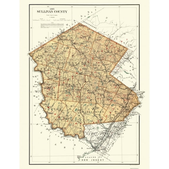
Old County Map - Sullivan New York Landowner - 1895 - This is an exquisite full-color Reproduction printed on high-quality gloss paper, art paper or canvas.
Print Size: 23.00 x 29.84 inches
58.42 X 75.71cm
Sites and Townships Specific To This Map Are: Port Jervis & Monticello Railroads, New York, Ontario & Western Railroads, New York, Lake Erie & Western Railroads, Falls Mill, Delaware & Hudson Canal, Hodge Pond, Lebanon Lake, Halfway Brook, Echo Lake, Delaware River, Brownville Railroad Station, Spring Glen Railroad Station & Some Named Landowners.
The following towns are featured: Lewbeach, Eureka, Neversink, Fremont Centre, White Sulphur Springs, Woodbourne, Huntington, Summitville, Winterton, Narrowsburg, Glen Spey & Oakland Valley.
This Map is Situated in: Sullivan County, New York.
SKU: NYSU0003
Original Maps are often difficult to find and usually have fold lines, identifying stamps or markings, tears, ragged edges, and assorted other natural signs of age that detract from their beauty. All of our maps have been professionally restored to depict their original beauty, while keeping all historical data intact.
These maps are fabulous pieces of history full of information useful to Historians, Genealogists, Cartographers, Relic Hunters, & Others. They make fascinating conversation pieces and splendid works of art for the home or office.
- HISTORICAL LOCAL MAPS MAKE GREAT WALL ART - Ever wonder what your country looked like during the early days of the USA? Well now you can find out! Maps of the Past provides maps from various time periods so you can track the history of your local city or town. These gorgiously detailed maps make for a great piece of art for your home or office. Own a piece of art and history today!
- LOCAL MAPS PROVIDE IMPORTANT INFORMATION - Local maps show you how the borders of a local are established and were they can be found. It also highlights rivers, mountains, and other natural element you may not know are there. Local maps can also show you transportation lanes across your local
- ONLY ACCEPT THE BEST PRINT QUALITY FOR YOUR REPRODUCTIONS - There are many printers and print types available on the market, when purchasing a reproduction there is no finer quality reproduction than a reproduction using the Giclee Printing method. Giclee describes the technique or style of printing used, and it is revered as the highest quality printing because of the way it precisely sprays ink onto a surface. Trust nothing less than the best!
- GUARNANTEED TO GET EXACTLY WHAT YOU ORDERED - This map comes exactly to the specification of 23.00 x 29.81 inches/58.42 X 75.71 cm. All of our maps come rolled, wrapped, and shipped in a heavy gauge mailing tube to ensure it arrives intact.
- WHY CHOOSE MAPS OF THE PAST? - Maps of the Past is one of the single largest producers of different types of maps. They legally own the rights to the maps they sell, and provide them to you in clean, clear, and vibrant print. If you are looking for a high quality map print, then look no further than Maps of the Past!
info:
We aim to show you accurate product information. Manufacturers, suppliers and others provide what you see here, and we have not verified it.
Specifications
Size
23 x 29.81
Material
Glossy Satin Photo Quality
Decor style
Vintage
Theme
Historical County Maps
Warranty
Warranty information
Please be aware that the warranty terms on items offered for sale by third party Marketplace sellers may differ from those displayed in this section (if any). To confirm warranty terms on an item offered for sale by a third party Marketplace seller, please use the 'Contact seller' feature on the third party Marketplace seller's information page and request the item's warranty terms prior to purchase.
Similar items you might like
Based on what customers bought
Historic County Map - Chittenden County Vermont - Beers 1878 - 23 x 28.25 - Vintage Wall Art $40.95 $40.95/count
 $4095current price $40.95$40.95/count
Historic County Map - Chittenden County Vermont - Beers 1878 - 23 x 28.25 - Vintage Wall Art
Historic County Map - Blackford County Indiana - Andreas 1876 - 28.31 x 23 - Vintage Wall Art $40.95 $40.95/count
 3 optionsAvailable in additional 3 options$4095current price $40.95$40.95/count
Historic County Map - Blackford County Indiana - Andreas 1876 - 28.31 x 23 - Vintage Wall Art
Historic Map - Bedfordshire County England - Cary 1792 - 23 x 33.41 - Vintage Wall Art $40.95 $40.95/count
 3 optionsAvailable in additional 3 options$4095current price $40.95$40.95/count
Historic Map - Bedfordshire County England - Cary 1792 - 23 x 33.41 - Vintage Wall Art
Historic Map - Buckinghamshire County England - Cary 1792 - 23 x 32.96 - Vintage Wall Art $40.95
 3 optionsAvailable in additional 3 options$4095current price $40.95
Historic Map - Buckinghamshire County England - Cary 1792 - 23 x 32.96 - Vintage Wall Art
Historic State Map - Massachusetts Region - 1776 - 23 x 41.47 - Vintage Wall Art $40.95 $40.95/count
 3 optionsAvailable in additional 3 options$4095current price $40.95$40.95/count
Historic State Map - Massachusetts Region - 1776 - 23 x 41.47 - Vintage Wall Art
Historic County Map - Fairfield County South Carolina - Mills 1825 - 31 x 23 - Vintage Wall Art $40.95 $40.95/count
 3 optionsAvailable in additional 3 options$4095current price $40.95$40.95/count
Historic County Map - Fairfield County South Carolina - Mills 1825 - 31 x 23 - Vintage Wall Art
Historic Map - Warwickshire County England - Cary 1792 - 23 x 34.76 - Vintage Wall Art $40.95 $40.95/count
 2 optionsAvailable in additional 2 options$4095current price $40.95$40.95/count
Historic Map - Warwickshire County England - Cary 1792 - 23 x 34.76 - Vintage Wall Art
Historic County Map - Fremont County California - Thompson 1876 - 23 x 35.93 - Vintage Wall Art $40.95
 3 optionsAvailable in additional 3 options$4095current price $40.95
Historic County Map - Fremont County California - Thompson 1876 - 23 x 35.93 - Vintage Wall Art
Historic County Map - Logan County Kansas - Everts 1887 - 23 x 27.72 - Vintage Wall Art $40.95
 3 optionsAvailable in additional 3 options$4095current price $40.95
Historic County Map - Logan County Kansas - Everts 1887 - 23 x 27.72 - Vintage Wall Art
Historic County Map - Hamilton County Indiana - Andreas 1876 - 23 x 29.06 - Vintage Wall Art $40.95 $40.95/count
 3 optionsAvailable in additional 3 options$4095current price $40.95$40.95/count
Historic County Map - Hamilton County Indiana - Andreas 1876 - 23 x 29.06 - Vintage Wall Art
Historic County Map - Adams Pennsylvania County - Hopkins 1857 - 32.38 x 23 - Vintage Wall Art $40.95 $40.95/count
 3 optionsAvailable in additional 3 options$4095current price $40.95$40.95/count
Historic County Map - Adams Pennsylvania County - Hopkins 1857 - 32.38 x 23 - Vintage Wall Art
Historic County Map - Hancock County Illinois - Warner 1870 - 23 x 27.78 - Vintage Wall Art $40.95
 3 optionsAvailable in additional 3 options$4095current price $40.95
Historic County Map - Hancock County Illinois - Warner 1870 - 23 x 27.78 - Vintage Wall Art
Historic State Map - Arizona Territory - Bien 1887 - 23 x 27.31 - Vintage Wall Art $40.95
 3 optionsAvailable in additional 3 options$4095current price $40.95
Historic State Map - Arizona Territory - Bien 1887 - 23 x 27.31 - Vintage Wall Art
Historic County Map - Horry County South Carolina - Mills 1825 - 30 x 23 - Vintage Wall Art $40.95 $40.95/count
 3 optionsAvailable in additional 3 options$4095current price $40.95$40.95/count
Historic County Map - Horry County South Carolina - Mills 1825 - 30 x 23 - Vintage Wall Art
Historic County Map - Monroe County Indiana - Andreas 1876 - 23 x 29.63 - Vintage Wall Art $40.95 $40.95/count
 3 optionsAvailable in additional 3 options$4095current price $40.95$40.95/count
Historic County Map - Monroe County Indiana - Andreas 1876 - 23 x 29.63 - Vintage Wall Art
Historic County Map - Los Angeles County California - Title Ins 1932 - 23 x 25.81 - Vintage Wall Art $40.95 $40.95/count
 3 optionsAvailable in additional 3 options$4095current price $40.95$40.95/count
Historic County Map - Los Angeles County California - Title Ins 1932 - 23 x 25.81 - Vintage Wall Art
Historic Map - Louth County Ireland - Bartholomew 1882 - 23 x 30.05 - Vintage Wall Art $40.95 $40.95/count
 3 optionsAvailable in additional 3 options$4095current price $40.95$40.95/count
Historic Map - Louth County Ireland - Bartholomew 1882 - 23 x 30.05 - Vintage Wall Art
Historic County Map - Modoc County California - Green 1911 - 24.31 x 23 - Vintage Wall Art $40.95 $40.95/count
 3 optionsAvailable in additional 3 options$4095current price $40.95$40.95/count
Historic County Map - Modoc County California - Green 1911 - 24.31 x 23 - Vintage Wall Art
Historic County Map - Wright County Minnesota - Andreas 1874 - 28.19 x 23 - Vintage Wall Art $40.95 $40.95/count
 3 optionsAvailable in additional 3 options$4095current price $40.95$40.95/count
Historic County Map - Wright County Minnesota - Andreas 1874 - 28.19 x 23 - Vintage Wall Art
Historic County Map - Mcpherson County Kansas - Everts 1887 - 23 x 36.51 - Vintage Wall Art $40.95 $40.95/count
 3 optionsAvailable in additional 3 options$4095current price $40.95$40.95/count
Historic County Map - Mcpherson County Kansas - Everts 1887 - 23 x 36.51 - Vintage Wall Art
Customer ratings & reviews
0 ratings|0 reviews
This item does not have any reviews yet

Related pages
- Council Bluffs Iowa Map
- Kentucky Counties Map
- Akron Ohio Map
- Cheyenne Wyoming Map
- West Virginia Map
- Map Brattleboro Vt
- Northeast United States Travel Books, Maps & Guides
- Midwest United States Travel Books, Maps & Guides
- Central America Travel Books, Maps & Guides
- General South America Travel Books, Maps & Guides
- Western United States Travel Books, Maps & Guides
- Ontario Travel Books, Maps & Guides