Simrad GO7 XSR - 7-inch Chartplotter with HDI Transducer, C-MAP Discover Chart Card
Key item features
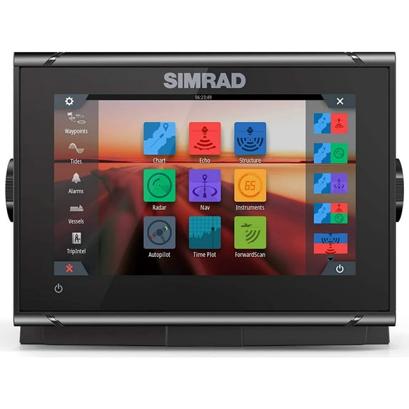
- Intuitive Display: Features a 7-inch multi-touch widescreen display with 800 x 480 resolution and 1200 nits brightness, offering easy-to-use controls and adjustable split-screen views.
- Advanced Sonar: Includes a built-in Broadband Sounder, CHIRP sonar, and supports StructureScan HD imaging or ForwardScan sonar with a required transducer, aiding in fish finding and underwater viewing.
- Radar Integration: Provides plug-and-play support for Simrad Broadband 3G/4G and Halo Pulse Compression radar systems, enhancing navigation safety and weather monitoring.
- Comprehensive Connectivity: Equipped with built-in GPS, internal Wi-Fi and Bluetooth, NMEA 2000 networking, and compatibility with the Simrad WM-3 SiriusXM satellite weather module (North America only).
- Navigation & Charting: Supports a wide range of charts including C-MAP Discover, Navionics, and Insight, with features like automatic routing (unavailable in North America) and Navionics SonarChart Live.
- Robust Design: Boasts a waterproof rating of IPX6 and IPX7, an operating temperature range of -15C to +55C, and flexible mounting options (bracket or panel).
- Included Accessories: Comes with an HDI Transom mount transducer, C-MAP Discover microSD card, power cable, mounting bracket, bezel, dash mount kit, suncover, and documentation.
Specs
- BrandSimrad
- Screen size7"
- FeaturesBacklit, Autopilot, Touchscreen, Transducer, CHIRP Sonar Technology
- Resolution800 x 480
- SeriesGO
- Model nameSimrad GO7 XSR
- Free shipping
 Free 30-day returns
(Only one option can be selected at a time)
How do you want your item?
About this item
Product details
- Simrad GO7 XSR 7" Plotter With HDI Tranducer C-map Discover microSD 000-14326-002
-
Simrad GO7 XSR 7" MFD with HDI transducer and C-Map Discover microSD
Model: 000-14326-002
- Easy to use multi-touch interface
- Radar display for Simrad Broadband 3G™/4G™ and Halo™ Pulse Compression radar
- Supports the widest range of charts
- Widescreen with bright LED backlight
- Built-in Broadband Sounder™, CHIRP sonar, StructureScan® HD imaging or ForwardScan™ sonar support (transducer required)
- Compatible with the Simrad WM-3 SiriusXM satellite weather module (North America only)
The Simrad GO7 XSR chartplotter navigation display is a perfect way to expand the capabilities of sportboats, cruisers, and smaller center consoles with plug-and-play support for Simrad Broadband Radar™ and Halo™ Pulse Compression radar systems. Behind a super-bright, multi-touch widescreen display lies a built-in GPS receiver, wireless connectivity, and industry standard NMEA 2000® networking. Connect with smartphones and tablets, control your onboard sound system, monitor engine data, and choose from an array of built-in sonar technology to cruise with confidence and find fish like a pro.
The GO series offers true ease of use with intuitive touchscreen controls that smartphone and tablet users will find instantly familiar. Customise your home screen with the features you use most, and see everything you need on screen at once with adjustable split-screen views.
The GO series offers true ease of use with intuitive touchscreen controls that smartphone and tablet users will find instantly familiar. Customise your home screen with the features you use most, and see everything you need on screen at once with adjustable split-screen views.
Add a suitable transducer and your GO series display works as a powerful fishfinder, complete with CHIRP technology for clear detection of fish throughout the water column. Add an HDI or TotalScan transducer, and your display also offers StructureScan HD sidescan imaging for a picture-like view of fish-holding structure beneath and around your boat.
Expand Your View with a Simrad Radar Solution The Simrad GO7 XSR is a full-featured radar display with plug-and-play connectivity to Simrad Broadband 3G™, Broadband 4G™, and Halo™ Pulse Compression radar systems. Cruise confidently through crowded harbours, navigate safely in poor visibility, keep an eye on distant weather cells, and find flocks of feeding birds that hint at good fishing spots. Automatic tuning helps to provide a clear radar picture in any conditions, while radar overlay combines radar data with navigational charts for an easy-to-interpret view of your surroundings. (end of section)
Automatic routing brings the convenience of in-car navigation to boating, helping you to plot a route and get underway with less delay. Simply select a destination, and your display will suggest the shortest, safest route. This feature is available with Navionics+ or Navionics Platinum charts (Navionics Dock-to-dock Autorouting), and C-MAP MAX-N+ charts (C-MAP Easy Routing). * Automatic routing features are unavailable in North America.
Enjoy the most up-to-date charts on the water with Navionics SonarChart Live. Available exclusively with Navionics charts, this feature creates a depth-contour overlay using live sonar data from your display’s built-in sounder. The results are shown on your GO series display and updated in real-time as you fish or cruise.
Designed with power boating in mind, the Simrad GO series offers a unique Cruise Charting page that brings together crucial navigation data and charts in one easily readable display.
The optional SonicHub®2 module is the perfect companion to your GO series display. Stream music from Bluetooth® connected tablets, smartphones, and other mobile devices with this black-box audio system that eliminates the need for a separate head unit.
The Simrad GO series provides access to online services including easy wireless map downloads and software updates via any wireless hotspot. On the water, connect your Simrad GO series display to your mobile devices, mirroring your display’s screen on your smartphone or giving you full remote control from your tablet with the free Link app.
* Built-in GPS receiver works in any bracket-mount installation, and when flush-mounted with most fibreglass hulls.
Specifications
Display Resolution 800 x 480 Screen brightness 1200 nits Size and type 7" Diagonal High Visibility Color TFT LCD Backlight color White Viewing angles 80° top/bottom, 80° left/right of center Electrical Recommended fuse rating 3A Power consumption(max) 20w Power consumption nominal 12w Supply voltage 12 V DC (10 - 17 V DC) Connectivity Ethernet 1 x 5 pin yellow connector x 1 Mbit. Radar and Sirius (USA only) connectivity only (unless unlocked) Radar compatibility Halo, Broadband, HD Radars Sonar Integrated CHIRP / DownScan / ForwardScan. Single 9 Pin Xsonic connector. Connection to any external sounder module is not supported. NMEA 2000 1 x NMEA 2000 Micro-C port, 1 LEN Video In / Out None WiFi Internal Bluetooth Internal GPS Antenna Internal GPS time to first fix Cold start less than 90 seconds exposed to open sky, Satellite reacquisition 5 sec GPS correction WASS, MSAS, EGNOS, GLONASS, *Galileo ,*BeiDou. *Limited by network GPS position accuracy Horizontal Accuracy 3 m (9.8 ft) GP receiver channels 32 Channels GPS update rate 10 Hz AIS Receive AIS data over NMEA 2000 only Enviromental Operating temperature range -15°C to +55°C (5° F to 131° F) Storage temperature range -20°C to +60°C (4°F to 140°F) Waterproof rating IPX 6 and 7 General Mounting methods Bracket or Panel Dimensions W x H x D 197 mm x 141 mm x 82.7 mm (7.56" x 5.55" x 3.26") (no bracket) Unswer interface Touch screen, OP40 or OP50 controller via NMEA 2000 Weather SiriusXM via WM-3 (USA only), GRIB Autopilot Auto, Nav., No Drift, Follow up, Non-follow up, Turn patterns, Standby, *Wind, *Wind NAV. (*Boat type set to Sail). System requires STBY button or Controller with STBY button to commission the pilot Digital switching BEP C-Zone Autopilot steering modes Auto, Nav., No Drift, Follow up, Non-follow up, Turn patterns, Standby, *Wind, *Wind NAV. (*Boat type set to Sail) Autopilot manoeuvres & turn patterns U-turn, Spiral-turn, C-turn, Zig-zag, Square-turn, Lazy S-turn, Depth contour tracking Internal user data storage 90MB Waypoints, routes and tracks 6000 waypoints, 500 Routes with 100 max route points, 50 tracks with up to 12,000 track points. External storage 2 Micro SD slots, max. 32GB (format FAT32 each). >32 GB cards require cards to be formated to NTFS Multimedia Via SonicHub2, FusionLink, *Sirius, **JL Audio. *USA only, **AUST. & NZ only) Supported cartography Insight, Navionics (Gold, NAV+ Platinum+), C-MAP (MAX N, MAX N+) NV Digital (Raster US Charts)
What's in the Box:- GO7 XSR
- Power cable
- Mounting bracket with knobs
- Bezel
- Dash mount kit
- Suncover
- Documentation
- HDI Transom mount transducer
- C-Map Discover microSD
- 000-14326-002
Specifications
Brand
Screen size
Features
Accessories
Warranty
Warranty information
Popular items in this category
Best selling items that customers love
Simrad GO9 XSE with Active Imaging 3-in-1 Transducer + C-Map Discover, GPS Chart-Plotter $999.00
 $99900current price $999.00More options from $799.00
Simrad GO9 XSE with Active Imaging 3-in-1 Transducer + C-Map Discover, GPS Chart-Plotter
83.9 out of 5 Stars. 8 reviewsShipping, arrives in 3+ daysSimrad NSX ULTRAWIDE 15" Chartplotter/Fish Finder,w/ActiveImaging 3-in-1 Transducer,C-MAP Chart Card $3,549.00
 $3,54900current price $3,549.00
Simrad NSX ULTRAWIDE 15" Chartplotter/Fish Finder,w/ActiveImaging 3-in-1 Transducer,C-MAP Chart Card
Shipping, arrives in 3+ daysSimrad NSX ULTRAWIDE 12" Chartplotter/Fish Finder,w/ActiveImaging 3-in-1 Transducer,C-MAP Chart Card $2,899.00
 $2,89900current price $2,899.00
Simrad NSX ULTRAWIDE 12" Chartplotter/Fish Finder,w/ActiveImaging 3-in-1 Transducer,C-MAP Chart Card
Shipping, arrives in 3+ daysSimrad GO9 XSE 9’’ Multifunctional Display with HALO20 Radar, 83/200 Transom Mount Transducer and C-MAP Discover Charts $1,999.00
 $1,99900current price $1,999.00
Simrad GO9 XSE 9’’ Multifunctional Display with HALO20 Radar, 83/200 Transom Mount Transducer and C-MAP Discover Charts
Shipping, arrives in 3+ daysSimrad NSS9 evo3S Chartplotter/Fishfinder MFD [000-15402-001] $2,399.00
![Simrad NSS9 evo3S Chartplotter/Fishfinder MFD [000-15402-001]](https://i5.walmartimages.com/asr/0e470e83-00d3-4be3-ab31-555f69dfd0d6.c0323f4477d89c50d0927773f868842f.jpeg?odnHeight=576&odnWidth=576&odnBg=FFFFFF) $2,39900current price $2,399.00
$2,39900current price $2,399.00Simrad NSS9 evo3S Chartplotter/Fishfinder MFD [000-15402-001]
264.7 out of 5 Stars. 26 reviewsShipping, arrives in 3+ daysGarmin Gpsmap1623 16in Gps Chart Plotter Worldwide Basemap $4,899.99
 $4,89999current price $4,899.99
Garmin Gpsmap1623 16in Gps Chart Plotter Worldwide Basemap
Shipping, arrives in 3+ daysC-MAP Reveal US Lakes North East $179.00
 $17900current price $179.00
C-MAP Reveal US Lakes North East
Shipping, arrives in 3+ daysSimrad GO7 XSR Chartplotter/Fishfinder w/C-MAP Discover Chart... [000-14078-002] $899.00
![Simrad GO7 XSR Chartplotter/Fishfinder w/C-MAP Discover Chart... [000-14078-002]](https://i5.walmartimages.com/asr/58410f97-cd68-4a63-8dd0-a588aafbccfe.df896da047ff9ba8ab9cfbd172743951.jpeg?odnHeight=576&odnWidth=576&odnBg=FFFFFF) $89900current price $899.00
$89900current price $899.00Simrad GO7 XSR Chartplotter/Fishfinder w/C-MAP Discover Chart... [000-14078-002]
31 out of 5 Stars. 3 reviewsShipping, arrives in 3+ daysEM90 Mini Portable High Precision Handheld GPS Navigation Track Land Area Meter with FSTN 2.4 inch Display Land Survey Measuring Instrument US Plug Land Area Tester $73.98
 $7398current price $73.98
EM90 Mini Portable High Precision Handheld GPS Navigation Track Land Area Meter with FSTN 2.4 inch Display Land Survey Measuring Instrument US Plug Land Area Tester
Shipping, arrives in 3+ daysMagellan TN7881SGLUC TR7 7 Inch Trail and Street GPS Navigator with Camera $326.79
 $32679current price $326.79
Magellan TN7881SGLUC TR7 7 Inch Trail and Street GPS Navigator with Camera
35 out of 5 Stars. 3 reviewsShipping, arrives in 3+ daysRaymarine Axiom 7 7in Chartplotter Lighhouse North Amercia Chart $929.99
 $92999current price $929.99
Raymarine Axiom 7 7in Chartplotter Lighhouse North Amercia Chart
134.5 out of 5 Stars. 13 reviewsShipping, arrives in 3+ days7" Lowrance EAGLE Triple Shot Fish Finder with IPS screen transducer C-MAP inland charts $376.00 Was $599.99
 4 optionsAvailable in additional 4 optionsNow$37600current price Now $376.00, Was $599.99$599.99More options from $349.99
7" Lowrance EAGLE Triple Shot Fish Finder with IPS screen transducer C-MAP inland charts
284.2 out of 5 Stars. 28 reviewsShipping, arrives in 3+ daysGPS Land Area Measure Handheld USB Navigation Track Area Calculation Meter 2.4-inch LED Backlit LCD Automatically Trajectory Meter $129.99
 $12999current price $129.99
GPS Land Area Measure Handheld USB Navigation Track Area Calculation Meter 2.4-inch LED Backlit LCD Automatically Trajectory Meter
34 out of 5 Stars. 3 reviewsShipping, arrives in 3+ daysHandheld GPS Plough Land Meter GPS Land Surveying Machine Professional GNSS receiver Area Measurement ,Easy to Use and Accurate $110.42
 $11042current price $110.42
Handheld GPS Plough Land Meter GPS Land Surveying Machine Professional GNSS receiver Area Measurement ,Easy to Use and Accurate
Shipping, arrives in 3+ daysRaymarine Axiom 12 - 12" MFD Chartplotter [E70638] $2,694.99
![Raymarine Axiom 12 - 12" MFD Chartplotter [E70638]](https://i5.walmartimages.com/asr/a7e09cc1-e5a9-4743-aa29-806505745050.531a390f772dbc8a5b6df74c060d29c8.jpeg?odnHeight=576&odnWidth=576&odnBg=FFFFFF) $2,69499current price $2,694.99
$2,69499current price $2,694.99Raymarine Axiom 12 - 12" MFD Chartplotter [E70638]
134.5 out of 5 Stars. 13 reviewsShipping, arrives in 3+ daysGarmin GPSMAP® 9024 24" Premium Chartplotter w/Worldwide Basemap $13,599.99
 $13,59999current price $13,599.99
Garmin GPSMAP® 9024 24" Premium Chartplotter w/Worldwide Basemap
Shipping, arrives in 3+ daysMagellan Outdoors TRX7 CS Pro 7 Inch Dual Mount GPS Navigator $514.99
 $51499current price $514.99
Magellan Outdoors TRX7 CS Pro 7 Inch Dual Mount GPS Navigator
13 out of 5 Stars. 1 reviewsShipping, arrives in 3+ days
