Hero image 0 of Historic Map - Gallia France - Spruner 1865 - 29.02 x 23 - Vintage Wall Art, 0 of 5
Historic Map - Gallia France - Spruner 1865 - 29.02 x 23 - Vintage Wall Art
(No ratings yet)
Key item features
- OWN A PIECE OF YOUR HOME COUNTRY - Looking for something that reminds you of the country you or your ancestors originate from? Well now you can own a piece of your heritage with a beautiful map of your home country. Maps of the Past has maps for every need!
- INTERNATIONAL MAPS PROVIDE IMPORTANT INFORMATION - International maps not only show you how the different countries, cities, counties, and territories are divided and where the borders can be found, but it also highlights rivers, mountains, and other natural elements of the land. International maps can also show you natural resources and exports of a country.
- ONLY ACCEPT THE BEST PRINT QUALITY FOR YOUR REPRODUCTIONS - There are many printers and print types available on the market, when purchasing a reproduction there is no finer quality reproduction than a reproduction using the Giclee Printing method. Giclee describes the technique or style of printing used, and it is revered as the highest quality printing because of the way it precisely sprays ink onto a surface. Trust nothing less than the best!
- GUARNANTEED TO GET EXACTLY WHAT YOU ORDERED - This map comes exactly to the specification of 23.00 x 29.01 inches/58.42 X 73.68 cm. All of our maps come rolled, wrapped, and shipped in a heavy gauge mailing tube to ensure it arrives intact.
- WHY CHOOSE MAPS OF THE PAST? - Maps of the Past is one of the single largest producers of different types of maps. They legally own the rights to the maps they sell, and provide them to you in clean, clear, and vibrant print. If you are looking for a high quality map print, then look no further than Maps of the Past!
Specs
- Color1
- Size23.00 x 29.01
- MaterialMatte Canvas
- Decor styleVintage
- ShapeRectangle
- Art typePainting
Price when purchased online
Not Available
How do you want your item?
Not available
About this item
Product details
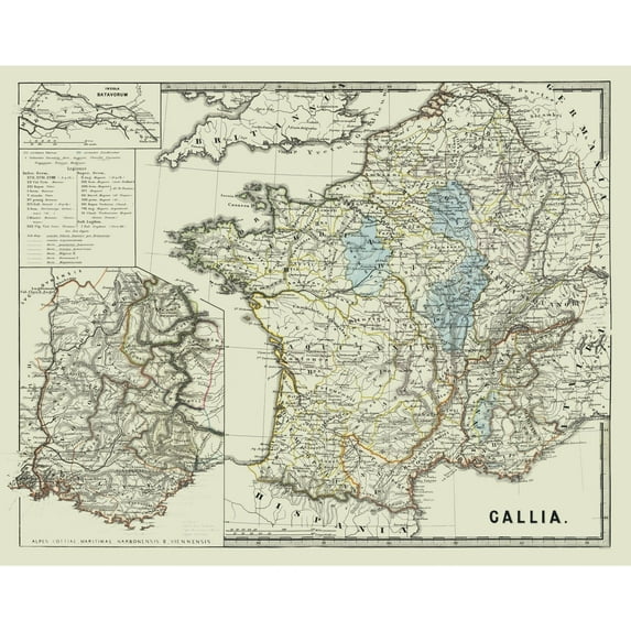
Old International Maps - Gallia - France - Spruner 1865 - This is an exquisite full-color Reproduction printed on high-quality gloss paper, art paper or canvas.
Print Size: 23.00 x 29.01 inches
58.42 X 73.68cm
The following towns are featured: Calagum, Ariolica, Novaria, Iria, Libarna, Mediolanum, Vesontia, Valentia, Tegna, Lugdunum, Ursolis.
This Map is Situated in: Gallia - France.
SKU: ITFR0211
Original Maps are often difficult to find and usually have fold lines, identifying stamps or markings, tears, ragged edges, and assorted other natural signs of age that detract from their beauty. All of our maps have been professionally restored to depict their original beauty, while keeping all historical data intact.
These maps are fabulous pieces of history full of information useful to Historians, Genealogists, Cartographers, Relic Hunters, & Others. They make fascinating conversation pieces and splendid works of art for the home or office.
- OWN A PIECE OF YOUR HOME COUNTRY - Looking for something that reminds you of the country you or your ancestors originate from? Well now you can own a piece of your heritage with a beautiful map of your home country. Maps of the Past has maps for every need!
- INTERNATIONAL MAPS PROVIDE IMPORTANT INFORMATION - International maps not only show you how the different countries, cities, counties, and territories are divided and where the borders can be found, but it also highlights rivers, mountains, and other natural elements of the land. International maps can also show you natural resources and exports of a country.
- ONLY ACCEPT THE BEST PRINT QUALITY FOR YOUR REPRODUCTIONS - There are many printers and print types available on the market, when purchasing a reproduction there is no finer quality reproduction than a reproduction using the Giclee Printing method. Giclee describes the technique or style of printing used, and it is revered as the highest quality printing because of the way it precisely sprays ink onto a surface. Trust nothing less than the best!
- GUARNANTEED TO GET EXACTLY WHAT YOU ORDERED - This map comes exactly to the specification of 23.00 x 29.01 inches/58.42 X 73.68 cm. All of our maps come rolled, wrapped, and shipped in a heavy gauge mailing tube to ensure it arrives intact.
- WHY CHOOSE MAPS OF THE PAST? - Maps of the Past is one of the single largest producers of different types of maps. They legally own the rights to the maps they sell, and provide them to you in clean, clear, and vibrant print. If you are looking for a high quality map print, then look no further than Maps of the Past!
info:
We aim to show you accurate product information. Manufacturers, suppliers and others provide what you see here, and we have not verified it.
Specifications
Color
1
Size
23.00 x 29.01
Material
Matte Canvas
Decor style
Vintage
Customer ratings & reviews
0 ratings|0 reviews
This item does not have any reviews yet

Check out these related products
Railroad Map - Denver Rio Grande Chicago Milwaukee - Reynold 1921 - 31.87 x 23 - Vintage Wall Art $45.95 Was $74.95
 3 optionsAvailable in additional 3 optionsNow$4595current price Now $45.95, Was $74.95$74.95You save $29.00You save$29.00More options from $40.95
Railroad Map - Denver Rio Grande Chicago Milwaukee - Reynold 1921 - 31.87 x 23 - Vintage Wall Art
Historic County Map - Colorado County Texas - Walsh 1880 - 23 x 24.01 - Vintage Wall Art $40.95
 3 optionsAvailable in additional 3 options$4095current price $40.95Options from $40.95 – $45.95
Historic County Map - Colorado County Texas - Walsh 1880 - 23 x 24.01 - Vintage Wall Art
Shipping, arrives in 3+ daysRailroad Map - Northern Pacific Pennsylvania Railroad - Reynold 1921 - 31.79 x 23 - Vintage Wall Art $45.95 Was $74.95
 3 optionsAvailable in additional 3 optionsNow$4595current price Now $45.95, Was $74.95$74.95You save $29.00You save$29.00More options from $40.95
Railroad Map - Northern Pacific Pennsylvania Railroad - Reynold 1921 - 31.79 x 23 - Vintage Wall Art
Shipping, arrives in 3+ daysRailroad Map - Colorado Delaware and Lackawanna Railroad - Reynold 1921 - 23 x 32.15 - Vintage Wall Art $45.95 Was $74.95
 3 optionsAvailable in additional 3 optionsNow$4595current price Now $45.95, Was $74.95$74.95You save $29.00You save$29.00More options from $40.95
Railroad Map - Colorado Delaware and Lackawanna Railroad - Reynold 1921 - 23 x 32.15 - Vintage Wall Art
Shipping, arrives in 3+ daysHistoric Map - Africa - Alden 1886 - 23 x 35.35 - Vintage Wall Art $45.95 Was $74.95
 3 optionsAvailable in additional 3 optionsNow$4595current price Now $45.95, Was $74.95$74.95You save $29.00You save$29.00More options from $40.95
Historic Map - Africa - Alden 1886 - 23 x 35.35 - Vintage Wall Art
Shipping, arrives in 3+ daysHistoric State Map - Missouri - Alden 1886 - 23 x 35.40 - Vintage Wall Art $45.95 Was $74.95
 3 optionsAvailable in additional 3 optionsNow$4595current price Now $45.95, Was $74.95$74.95You save $29.00You save$29.00More options from $40.95
Historic State Map - Missouri - Alden 1886 - 23 x 35.40 - Vintage Wall Art
Shipping, arrives in 3+ days