
Hero image 0 of Topographical Map - Howard Montgomery Counties Maryland - Gray 1873 - 23 x 27.63 - Vintage Wall Art, 0 of 1
Topographical Map - Howard Montgomery Counties Maryland - Gray 1873 - 23 x 27.63 - Vintage Wall Art
(No ratings yet)
Key item features
- OWN A HISTORICAL TOPOGRAPHICAL MAP TODAY - Topographical maps provide you a birds-eye view of how the topography of certain pieces of land are mapped out. See how much today's maps have changed from centuries ago. See how waterways have shifted, or how forrests have become thralling cities. See how history has changed the landscape with a topographical map today!
- TOPOGRAPHICAL MAPS PROVIDE IMPORTANT INFORMATION -Topographical maps show you how the borders of a county are established and were they can be found. It also highlights rivers, mountains, and other natural elements, and it will show you where the cities are located within it.
- ONLY ACCEPT THE BEST PRINT QUALITY FOR YOUR REPRODUCTIONS - There are many printers and print types available on the market, when purchasing a reproduction there is no finer quality reproduction than a reproduction using the Giclee Printing method. Giclee describes the technique or style of printing used, and it is revered as the highest quality printing because of the way it precisely sprays ink onto a surface. Trust nothing less than the best!
- GUARNANTEED TO GET EXACTLY WHAT YOU ORDERED - This map comes exactly to the specification of 23.00 x 27.63 inches/58.42 X 70.18 cm. All of our maps come rolled, wrapped, and shipped in a heavy gauge mailing tube to ensure it arrives intact.
- WHY CHOOSE MAPS OF THE PAST? - Maps of the Past is one of the single largest producers of different types of maps. They legally own the rights to the maps they sell, and provide them to you in clean, clear, and vibrant print. If you are looking for a high quality map print, then look no further than Maps of the Past!
Specs
- Size23.00 x 27.63
- MaterialMatte Art
- Decor styleVintage
- ThemeHistoric Topographic Maps
- ShapeRectangle
- Art typePainting
Current price is USDNow $45.95
You save $29.00
was $74.95$74.95
$45.95/countYou save$29.00
Price when purchased online
- Free shipping
 Free 30-day returns
How do you want your item?
Columbus, 43215
Arrives between Feb 23 - Feb 25
|Sold and shipped by Maps of the Past
4.3 stars out of 5, based on 10 seller reviews(4.3)10 seller reviews
Free 30-day returns
Popular items in this category
Best selling items that customers love
North Carolina Map - 11x14 Unframed Art Print - Great Vintage Gift and Decor for History Buffs and Old Map Enthusiasts Under $15 $14.99
 $1499current price $14.99
North Carolina Map - 11x14 Unframed Art Print - Great Vintage Gift and Decor for History Buffs and Old Map Enthusiasts Under $15
Shipping, arrives in 3+ daysMadison Park Royal Cat Portrait Renaissance Style Framed Canvas Wall Art, King Charles, 16.5"W x 20.5"H $12.79
 6 optionsAvailable in additional 6 options$1279current price $12.79
Madison Park Royal Cat Portrait Renaissance Style Framed Canvas Wall Art, King Charles, 16.5"W x 20.5"H
304.9 out of 5 Stars. 30 reviewsSave with Shipping, arrives tomorrow
Kate and Laurel Sylvie Milwaukee Modern Map Framed Canvas Wall Art by Jake Goossen, 18x24 Gray, Decorative Map Art for Wall $54.99
 $5499current price $54.99
Kate and Laurel Sylvie Milwaukee Modern Map Framed Canvas Wall Art by Jake Goossen, 18x24 Gray, Decorative Map Art for Wall
Shipping, arrives in 3+ days1818 Map of Washington DC Art Print - 11x14 Unframed Art Print - Great Vintage Home Decor $14.99
 $1499current price $14.99
1818 Map of Washington DC Art Print - 11x14 Unframed Art Print - Great Vintage Home Decor
Shipping, arrives in 3+ days48x78 Huge United States, USA Contemporary Elite Wall Map Laminated $44.00
 3 optionsAvailable in additional 3 options$4400current price $44.00More options from $18.90
48x78 Huge United States, USA Contemporary Elite Wall Map Laminated
114.1 out of 5 Stars. 11 reviewsShipping, arrives in 3+ daysHISTORIX 1862 United States Railroad and Military Map Vintage Poster Wall Art Print, 18 x 24 Inch $39.99
 2 optionsAvailable in additional 2 options$3999current price $39.99Options from $39.99 – $59.99
HISTORIX 1862 United States Railroad and Military Map Vintage Poster Wall Art Print, 18 x 24 Inch
Shipping, arrives in 3+ daysJEUXUS Framed Canvas Print Wall Art Set Black Gray White Geometric Paint Strokes Abstract Shapes Illustrations Modern Art Decorative Contemporary for Living Room, Bedroom, Office $16.95
 6 optionsAvailable in additional 6 options$1695current price $16.95Options from $16.95 – $24.44
JEUXUS Framed Canvas Print Wall Art Set Black Gray White Geometric Paint Strokes Abstract Shapes Illustrations Modern Art Decorative Contemporary for Living Room, Bedroom, Office
15 out of 5 Stars. 1 reviewsShipping, arrives in 3+ daysBest seller Country Floral Wall Art for Living Room, Blue and Yellow Flower with Green Botanical Canvas Wall Art, Retro Wood Boards Framed Wall Art for Bedroom Bathroom Wall Decor, 16X12 inch Ready to Hang $13.50
Best seller


 Sponsored$1350current price $13.50Options from $13.50 – $18.99
Country Floral Wall Art for Living Room, Blue and Yellow Flower with Green Botanical Canvas Wall Art, Retro Wood Boards Framed Wall Art for Bedroom Bathroom Wall Decor, 16X12 inch Ready to Hang
194.8 out of 5 Stars. 19 reviewsSave withShipping, arrives tomorrowKate and Laurel Sylvie Nashville Modern Map Framed Canvas Wall Art by Jake Goossen, 18x24 Gray, Decorative Map Art for Wall $54.99
 $5499current price $54.99
Kate and Laurel Sylvie Nashville Modern Map Framed Canvas Wall Art by Jake Goossen, 18x24 Gray, Decorative Map Art for Wall
Shipping, arrives in 3+ days1845 Michigan Map Art Print - 11x14 Unframed Art Print - Great Vintage Home Decor $14.99
 $1499current price $14.99
1845 Michigan Map Art Print - 11x14 Unframed Art Print - Great Vintage Home Decor
Shipping, arrives in 3+ days1938 Michigan Map Art Print - 11x14 Unframed Art Print - Great Vintage Home Decor $14.99
 $1499current price $14.99
1938 Michigan Map Art Print - 11x14 Unframed Art Print - Great Vintage Home Decor
Shipping, arrives in 3+ daysBest seller America's Natural Wonders National Parks Quarters Collection Map $5.99 Was $11.99
Best seller Now$599current price Now $5.99, Was $11.99$11.99+$6.24 shippingYou save $6.00You save$6.00
America's Natural Wonders National Parks Quarters Collection Map
244.8 out of 5 Stars. 24 reviewsShipping, arrives in 3+ daysStupell Industries Potomac River Chesapeake Bay Coastal Map Beige Blue Vintage Painting Unframed Art Print Wall Art, 10 x 15, Design by Daphne Polselli $32.99
 15 optionsAvailable in additional 15 options$3299current price $32.99More options from $23.76
Stupell Industries Potomac River Chesapeake Bay Coastal Map Beige Blue Vintage Painting Unframed Art Print Wall Art, 10 x 15, Design by Daphne Polselli
15 out of 5 Stars. 1 reviewsSave withShipping, arrives in 2 daysNorthlight Patriotic “Proud to be an American” Wooden USA Map Wall Art - 15.75” x 12” $18.99
 $1899current price $18.99
Northlight Patriotic “Proud to be an American” Wooden USA Map Wall Art - 15.75” x 12”
Shipping, arrives in 3+ daysCarolina Living Circle Abstract Wall Art - Blue/Silver - Silver Frame - Medium $43.46 Was $50.16
 Now$4346current price Now $43.46, Was $50.16$50.16You save $6.70You save$6.70
Carolina Living Circle Abstract Wall Art - Blue/Silver - Silver Frame - Medium
12 out of 5 Stars. 1 reviewsShipping, arrives in 3+ days
About this item
Product details
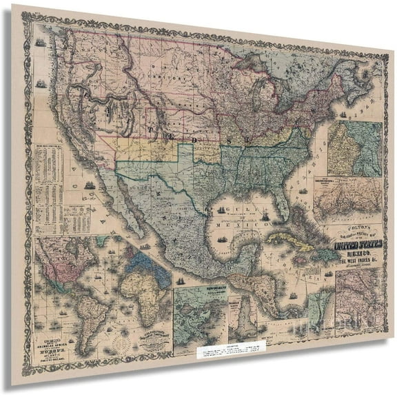
Topographical Map - Howard, Montgomery Counties Maryland - 1873 - This is an exquisite full-color Reproduction printed on high-quality gloss paper, art paper or canvas.
Print Size: 23.00 x 27.63 inches
58.42 X 70.18cm
Sites and Townships Specific To This Map Are: Baltimore, Clarksburg, Medley, Rockville, Crackley, Berry, Vansville, Bladensburgh, Drainsville, Lewinsville
The following towns are featured: Howard County, Montgomery County, District of Columbia Districts 1-6 of Howard County noted. Post Offices: Park Mills P.O., Urbana P.O., Tjansville P.O., Kemptown P.O., Ridgeville P.O., Hyattstown P.O., Damascus P.O., Greenfield Mills P.O., Beallsville P.O., Clarksburg P.O., Cooksville P.O., West Friendship P.O., Marriotsville P.O., Clarksville P.O., Simpsonville P.O., Middlebrook P.O. Rail Roads shown include Metropolitan Branch Rail Road, Baltimore and Potomac R.R., and Washington Branch R.R. Also Chesapeake and Ohio Canal, Big Patuxent, Little Patuxent and Patuxent Rivers. Monocacy River, Middle River, Potomac Acquaduct, and Great Falls of the Potomac River.
This Map is Situated in: Howard County, Maryland (MD) Montgomery County, Maryland (MD) and the District of Columbia
SKU: MDHO0002
Original Maps are often difficult to find and usually have fold lines, identifying stamps or markings, tears, ragged edges, and assorted other natural signs of age that detract from their beauty. All of our maps have been professionally restored to depict their original beauty, while keeping all historical data intact.
These maps are fabulous pieces of history full of information useful to Historians, Genealogists, Cartographers, Relic Hunters, & Others. They make fascinating conversation pieces and splendid works of art for the home or office.
- OWN A HISTORICAL TOPOGRAPHICAL MAP TODAY - Topographical maps provide you a birds-eye view of how the topography of certain pieces of land are mapped out. See how much today's maps have changed from centuries ago. See how waterways have shifted, or how forrests have become thralling cities. See how history has changed the landscape with a topographical map today!
- TOPOGRAPHICAL MAPS PROVIDE IMPORTANT INFORMATION -Topographical maps show you how the borders of a county are established and were they can be found. It also highlights rivers, mountains, and other natural elements, and it will show you where the cities are located within it.
- ONLY ACCEPT THE BEST PRINT QUALITY FOR YOUR REPRODUCTIONS - There are many printers and print types available on the market, when purchasing a reproduction there is no finer quality reproduction than a reproduction using the Giclee Printing method. Giclee describes the technique or style of printing used, and it is revered as the highest quality printing because of the way it precisely sprays ink onto a surface. Trust nothing less than the best!
- GUARNANTEED TO GET EXACTLY WHAT YOU ORDERED - This map comes exactly to the specification of 23.00 x 27.63 inches/58.42 X 70.18 cm. All of our maps come rolled, wrapped, and shipped in a heavy gauge mailing tube to ensure it arrives intact.
- WHY CHOOSE MAPS OF THE PAST? - Maps of the Past is one of the single largest producers of different types of maps. They legally own the rights to the maps they sell, and provide them to you in clean, clear, and vibrant print. If you are looking for a high quality map print, then look no further than Maps of the Past!
info:
We aim to show you accurate product information. Manufacturers, suppliers and others provide what you see here, and we have not verified it.
Specifications
Size
23.00 x 27.63
Material
Matte Art
Decor style
Vintage
Theme
Historic Topographic Maps
Warranty
Warranty information
Please be aware that the warranty terms on items offered for sale by third party Marketplace sellers may differ from those displayed in this section (if any). To confirm warranty terms on an item offered for sale by a third party Marketplace seller, please use the 'Contact seller' feature on the third party Marketplace seller's information page and request the item's warranty terms prior to purchase.
Customer ratings & reviews
0 ratings|0 reviews
This item does not have any reviews yet

Related pages
- Scenic Indiana United States Travel Books Maps Guides
- Map Florida Keys
- Best Sellers In Minneapolis St Paul Minnesota Travel Books
- Alabama County Map Roads
- Jersey Counties Map Cities
- Texas County Maps with Cities
- Midwest United States Travel Books, Maps & Guides
- Central America Travel Books, Maps & Guides
- Northeast United States Travel Books, Maps & Guides
- Western United States Travel Books, Maps & Guides
- General South America Travel Books, Maps & Guides
- Peru Travel Books, Maps & Guides