Hero image 0 of Historic City Map - Des Moines Iowa - Andreas 1875 - 29.63 x 23 - Vintage Wall Art, 0 of 5
Historic City Map - Des Moines Iowa - Andreas 1875 - 29.63 x 23 - Vintage Wall Art
(No ratings yet)
Key item features
- HISTORICAL LOCAL MAPS MAKE GREAT WALL ART - Ever wonder what your country looked like during the early days of the USA? Well now you can find out! Maps of the Past provides maps from various time periods so you can track the history of your local city or town. These gorgiously detailed maps make for a great piece of art for your home or office. Own a piece of art and history today!
- LOCAL MAPS PROVIDE IMPORTANT INFORMATION - Local maps show you how the borders of a local are established and were they can be found. It also highlights rivers, mountains, and other natural element you may not know are there. Local maps can also show you transportation lanes across your local
- ONLY ACCEPT THE BEST PRINT QUALITY FOR YOUR REPRODUCTIONS - There are many printers and print types available on the market, when purchasing a reproduction there is no finer quality reproduction than a reproduction using the Giclee Printing method. Giclee describes the technique or style of printing used, and it is revered as the highest quality printing because of the way it precisely sprays ink onto a surface. Trust nothing less than the best!
- GUARNANTEED TO GET EXACTLY WHAT YOU ORDERED - This map comes exactly to the specification of 29.63 x 23.00 inches/75.26 X 58.42 cm. All of our maps come rolled, wrapped, and shipped in a heavy gauge mailing tube to ensure it arrives intact.
- WHY CHOOSE MAPS OF THE PAST? - Maps of the Past is one of the single largest producers of different types of maps. They legally own the rights to the maps they sell, and provide them to you in clean, clear, and vibrant print. If you are looking for a high quality map print, then look no further than Maps of the Past!
Specs
- Size29.63 x 23
- MaterialGlossy Satin Photo Quality
- Decor styleVintage
- ThemeHistorical City Maps
- ShapeRectangle
- Art typePainting
Current price is USD$40.95$40.95/count
Price when purchased online
- Free shipping
 Free 30-day returns
How do you want your item?
Columbus, 43215
Arrives between Feb 28 - Mar 3
|Sold and shipped by Maps of the Past
4.3 stars out of 5, based on 10 seller reviews(4.3)10 seller reviews
Free 30-day returns
About this item
Product details
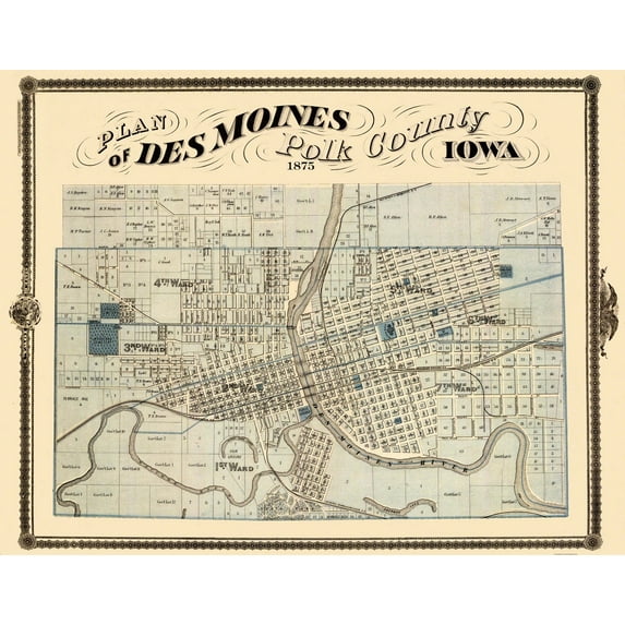
Old City Map - Des Moines Iowa Landowner - 1875 - This is an exquisite full-color Reproduction printed on high-quality gloss paper, art paper or canvas.
Print Size: 23.00 x 29.60 inches
75.26 X 58.42cm
Sites and Townships Specific To This Map Are: This elegant map of the city of Des Moines, Iowa represents a early look at the turn of the century American city. Roads, Highways, Streets, Wards, Cemeteries, Buildings of Prominence, County Courthouse, Post Offices, Other Structures of Significance. Terrace Hill, South Park, Des Moines & Minnesota Railroad, Chicago, Rock Island, & Pacific Railroad, Des Moines, Indianola, & Missouri Railroad, Keokuk & Des Moines Railroad, Racoon River, Sherman Lake, Dean Lake & Lake Ann.
The following towns are featured: Des Moines.
This Map is Situated in: Polk County, Iowa.
SKU: IAPO0001
Original Maps are often difficult to find and usually have fold lines, identifying stamps or markings, tears, ragged edges, and assorted other natural signs of age that detract from their beauty. All of our maps have been professionally restored to depict their original beauty, while keeping all historical data intact.
These maps are fabulous pieces of history full of information useful to Historians, Genealogists, Cartographers, Relic Hunters, & Others. They make fascinating conversation pieces and splendid works of art for the home or office.
- HISTORICAL LOCAL MAPS MAKE GREAT WALL ART - Ever wonder what your country looked like during the early days of the USA? Well now you can find out! Maps of the Past provides maps from various time periods so you can track the history of your local city or town. These gorgiously detailed maps make for a great piece of art for your home or office. Own a piece of art and history today!
- LOCAL MAPS PROVIDE IMPORTANT INFORMATION - Local maps show you how the borders of a local are established and were they can be found. It also highlights rivers, mountains, and other natural element you may not know are there. Local maps can also show you transportation lanes across your local
- ONLY ACCEPT THE BEST PRINT QUALITY FOR YOUR REPRODUCTIONS - There are many printers and print types available on the market, when purchasing a reproduction there is no finer quality reproduction than a reproduction using the Giclee Printing method. Giclee describes the technique or style of printing used, and it is revered as the highest quality printing because of the way it precisely sprays ink onto a surface. Trust nothing less than the best!
- GUARNANTEED TO GET EXACTLY WHAT YOU ORDERED - This map comes exactly to the specification of 29.63 x 23.00 inches/75.26 X 58.42 cm. All of our maps come rolled, wrapped, and shipped in a heavy gauge mailing tube to ensure it arrives intact.
- WHY CHOOSE MAPS OF THE PAST? - Maps of the Past is one of the single largest producers of different types of maps. They legally own the rights to the maps they sell, and provide them to you in clean, clear, and vibrant print. If you are looking for a high quality map print, then look no further than Maps of the Past!
info:
We aim to show you accurate product information. Manufacturers, suppliers and others provide what you see here, and we have not verified it.
Specifications
Size
29.63 x 23
Material
Glossy Satin Photo Quality
Decor style
Vintage
Theme
Historical City Maps
Warranty
Warranty information
Please be aware that the warranty terms on items offered for sale by third party Marketplace sellers may differ from those displayed in this section (if any). To confirm warranty terms on an item offered for sale by a third party Marketplace seller, please use the 'Contact seller' feature on the third party Marketplace seller's information page and request the item's warranty terms prior to purchase.
Similar items you might like
Based on what customers bought
Historic City Map - Broadkiln Delaware - Beers 1868 - 23 x 25.75 - Vintage Wall Art $45.95 Was $74.95
 3 optionsAvailable in additional 3 options$4595current price $45.95, Was $74.95$74.95
Historic City Map - Broadkiln Delaware - Beers 1868 - 23 x 25.75 - Vintage Wall Art
Historic State Map - Nebraska Kansas - Colton 1875 - 23 x 35.34 - Vintage Wall Art $45.95 Was $74.95
 4 optionsAvailable in additional 4 options$4595current price $45.95, Was $74.95$74.95
Historic State Map - Nebraska Kansas - Colton 1875 - 23 x 35.34 - Vintage Wall Art
Historic City Map - Natchez Mississippi - Collot 1796 - 23 x 31.60 - Vintage Wall Art $45.95 Was $74.95 $45.95/count
 3 optionsAvailable in additional 3 options$4595current price $45.95, Was $74.95$74.95$45.95/count
Historic City Map - Natchez Mississippi - Collot 1796 - 23 x 31.60 - Vintage Wall Art
Historic City Map - Hardy Ohio - Cring 1875 - 23 x 25.21 - Vintage Wall Art $45.95 Was $74.95 $45.95/count
 3 optionsAvailable in additional 3 options$4595current price $45.95, Was $74.95$74.95$45.95/count
Historic City Map - Hardy Ohio - Cring 1875 - 23 x 25.21 - Vintage Wall Art
Historic City Map - Jewett City Niantic Connecticut - Hurd 1893 - 23 x 26.70 - Vintage Wall Art $45.95 Was $74.95 $45.95/count
 3 optionsAvailable in additional 3 options$4595current price $45.95, Was $74.95$74.95$45.95/count
Historic City Map - Jewett City Niantic Connecticut - Hurd 1893 - 23 x 26.70 - Vintage Wall Art
Historic City Map - Tuscarawas Ohio - Lawrence 1896 - 23 x 31.14 - Vintage Wall Art $45.95 Was $74.95
 3 optionsAvailable in additional 3 options$4595current price $45.95, Was $74.95$74.95
Historic City Map - Tuscarawas Ohio - Lawrence 1896 - 23 x 31.14 - Vintage Wall Art
Historic County Map - Union County Iowa - Andreas 1874 - 23 x 29.69 - Vintage Wall Art $45.95 Was $74.95
 3 optionsAvailable in additional 3 options$4595current price $45.95, Was $74.95$74.95
Historic County Map - Union County Iowa - Andreas 1874 - 23 x 29.69 - Vintage Wall Art
Historic State Map - Oregon - USGLO 1866 - 23 x 29.50 - Vintage Wall Art $45.95 Was $74.95
 3 optionsAvailable in additional 3 options$4595current price $45.95, Was $74.95$74.95
Historic State Map - Oregon - USGLO 1866 - 23 x 29.50 - Vintage Wall Art
Historic County Map - Johnson County Iowa - Andreas 1874 - 23 x 28.44 - Vintage Wall Art $45.95 Was $74.95 $45.95/count
 3 optionsAvailable in additional 3 options$4595current price $45.95, Was $74.95$74.95$45.95/count
Historic County Map - Johnson County Iowa - Andreas 1874 - 23 x 28.44 - Vintage Wall Art
Historic City Map - Fort Worth Texas - Gray 1885 - 23 x 34.71 - Vintage Wall Art $45.95 Was $74.95
 3 optionsAvailable in additional 3 options$4595current price $45.95, Was $74.95$74.95
Historic City Map - Fort Worth Texas - Gray 1885 - 23 x 34.71 - Vintage Wall Art
Historic City Map - Decatur Sullivan Illinois - Warner 1876 - 23 x 28.94 - Vintage Wall Art $45.95 Was $74.95 $45.95/count
 3 optionsAvailable in additional 3 options$4595current price $45.95, Was $74.95$74.95$45.95/count
Historic City Map - Decatur Sullivan Illinois - Warner 1876 - 23 x 28.94 - Vintage Wall Art
Historic County Map - Dubuque County Iowa - Shober 1875 - 23 x 30 - Vintage Wall Art $45.95 Was $74.95 $45.95/count
 3 optionsAvailable in additional 3 options$4595current price $45.95, Was $74.95$74.95$45.95/count
Historic County Map - Dubuque County Iowa - Shober 1875 - 23 x 30 - Vintage Wall Art
Historic County Map - Jefferson County Indiana - Andreas 1876 - 28.63 x 23 - Vintage Wall Art $45.95 Was $74.95
 3 optionsAvailable in additional 3 options$4595current price $45.95, Was $74.95$74.95
Historic County Map - Jefferson County Indiana - Andreas 1876 - 28.63 x 23 - Vintage Wall Art
Historic City Map - Bloomington Indiana - Sanborn 1887 - 23 x 27.19 - Vintage Wall Art $45.95 Was $74.95 $45.95/count
 3 optionsAvailable in additional 3 options$4595current price $45.95, Was $74.95$74.95$45.95/count
Historic City Map - Bloomington Indiana - Sanborn 1887 - 23 x 27.19 - Vintage Wall Art
Historic State Map - America Septentrionali - 1751 - 26.63 x 23 - Vintage Wall Art $45.95 Was $74.95 $45.95/count
 3 optionsAvailable in additional 3 options$4595current price $45.95, Was $74.95$74.95$45.95/count
Historic State Map - America Septentrionali - 1751 - 26.63 x 23 - Vintage Wall Art
Historic State Map - Michigan - Greenleaf 1841 - 23 x 27.06 - Vintage Wall Art $40.95 $40.95/count
 3 optionsAvailable in additional 3 options$4095current price $40.95$40.95/count
Historic State Map - Michigan - Greenleaf 1841 - 23 x 27.06 - Vintage Wall Art
Historic City Map - Oswego New York - Stone 1866 - 23 x 38.16 - Vintage Wall Art $40.95
 3 optionsAvailable in additional 3 options$4095current price $40.95
Historic City Map - Oswego New York - Stone 1866 - 23 x 38.16 - Vintage Wall Art
Historic State Map - Indiana Political - Baskin 1876 - 23 x 28.74 - Vintage Wall Art $40.95 $40.95/count
 3 optionsAvailable in additional 3 options$4095current price $40.95$40.95/count
Historic State Map - Indiana Political - Baskin 1876 - 23 x 28.74 - Vintage Wall Art
Historic County Map - Knox County Indiana - Andreas 1876 - 23 x 28.44 - Vintage Wall Art $40.95 $40.95/count
 3 optionsAvailable in additional 3 options$4095current price $40.95$40.95/count
Historic County Map - Knox County Indiana - Andreas 1876 - 23 x 28.44 - Vintage Wall Art
Historic City Map - Franklin Pennsylvania - Mayer 1865 - 26 x 23 - Vintage Wall Art $40.95
 3 optionsAvailable in additional 3 options$4095current price $40.95
Historic City Map - Franklin Pennsylvania - Mayer 1865 - 26 x 23 - Vintage Wall Art
Customer ratings & reviews
0 ratings|0 reviews
This item does not have any reviews yet

Related pages
- Council Bluffs Iowa Map
- Cheyenne Wyoming Map
- Map Brattleboro Vt
- Missouri To South Dakota
- North Alabama Maps
- Fort Knox Map
- Central America Travel Books, Maps & Guides
- Midwest United States Travel Books, Maps & Guides
- General South America Travel Books, Maps & Guides
- Northeast United States Travel Books, Maps & Guides
- Western United States Travel Books, Maps & Guides
- Southern United States Travel Books, Maps & Guides