Hero image 0 of Historical Civil War Map - Western Border States Military Portraits - Lloyd 1861 - 23 x 28.54 - Vintage Wall Art, 0 of 5
Historical Civil War Map - Western Border States Military Portraits - Lloyd 1861 - 23 x 28.54 - Vintage Wall Art
(No ratings yet)
Historical Civil War Map - Western Border States Military Portraits - Lloyd 1861 - 23 x 28.54 - Vintage Wall ArtHistorical Civil War Map Western Border States Military Portraits Lloyd 1861 23 x 28 54 Vintage Wall ArtHistorical Civil War Map Western Border States Military Portraits Lloyd 1861 23 x 28 54 Vintage Wall Art
Material:Glossy Satin Photo Quality
Key item features
- MAP OF THE CIVIL WAR ERA UNITED STATES - Ever wonder what a certain state or region looked like during the Civil War? Now you can see for yourself and own a piece of USA history! We have maps of colonies, states, all the way up to the entire eastern half of North America. Our maps date all the way back to as early as the 1700's!
- GREAT COMPLIMENT TO ANY COLLECTION - If you are a Civil war-buff, then you likely own a number of pieces of memorabelia from that era. Some items may be replica's, and if you are lucky, some items are originals. A beautiful map from the Civil War era is a great compliment to any collection and adds a finishing touch to collection rooms!
- ONLY ACCEPT THE BEST PRINT QUALITY FOR YOUR REPRODUCTIONS - There are many printers and print types available on the market, when purchasing a reproduction there is no finer quality reproduction than a reproduction using the Giclee Printing method. Giclee describes the technique or style of printing used, and it is revered as the highest quality printing because of the way it precisely sprays ink onto a surface. Trust nothing less than the best!
- GUARNANTEED TO GET EXACTLY WHAT YOU ORDERED - This map comes exactly to the specification of 23.00 x 28.54 inches/58.42 X 72.49 cm. All of our maps come rolled, wrapped, and shipped in a heavy gauge mailing tube to ensure it arrives intact.
- WHY CHOOSE MAPS OF THE PAST? - Maps of the Past is one of the single largest producers of different types of maps. They legally own the rights to the maps they sell, and provide them to you in clean, clear, and vibrant print. If you are looking for a high quality map print, then look no further than Maps of the Past!
Specs
- Size23.00 x 28.54
- OrientationPortrait
- MaterialGlossy Satin Photo Quality
- Decor styleVintage
- ThemeCivil War Maps
- ShapeRectangle
Current price is USD$40.95$40.95/count
Price when purchased online
- Free shipping
 Free 30-day returns
How do you want your item?
Columbus, 43215
Arrives between Feb 28 - Mar 3
|Sold and shipped by Maps of the Past
4.3 stars out of 5, based on 10 seller reviews(4.3)10 seller reviews
Free 30-day returns
About this item
Product details
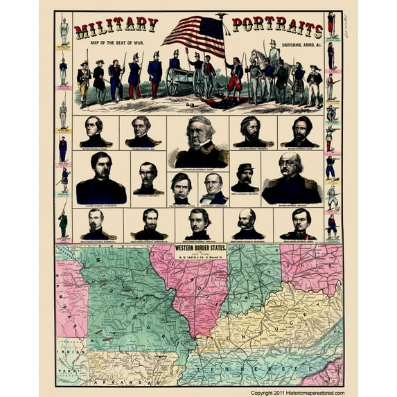
Civil War Map - Western Border States & Military Portraits - 1861 - This is an exquisite full-color Reproduction printed on high-quality gloss paper, art paper or canvas.
Print Size: 23.00 x 28.54 inches
58.42 X 72.49cm
Sites and Townships Specific To This Map Are: Tecumseh, Lecompton, St. Joseph, Lexington, Carthage, Springfield, Wilsons Creek, Pocahontas, Lebanon, Forsyth, Pilot Knob, Rolla, Jefferson City, St. Louis, Pacific RR, Boonville, Palmyra, Memphis, Springfield, Terra Haute, Evansville, Cairo, Columbus, Union City, Hickman, Decatur, Nashville, Knoxville, Frankfort, Lexington, Louisville, Madison, New Albany, Cincinnati, Indianapolis, Dayton, Chillicothe and many more.
The following towns are featured: Kansas River, Missouri River, St. Joseph RR, Arkansas River, Canadian River, Neosho River, Lake St. Francis, White River, Little Red River, Osage River, Mississippi River, Wabash & Western RR, Illinois Central RR, Mississippi & Ohio RR, Tennessee River, Ohio River, Memphis & Ohio RR, Covington & Lexington RR, Indiana Central RR, Madison & Indianapolis RR, Cumberland Mts., Mt. Pleasant, Great Smoky Mts., East Tennessee & Virginia RR and many more. This unique map also includes portraits of Ranking Off
SKU: CWUS0008
Original Maps are often difficult to find and usually have fold lines, identifying stamps or markings, tears, ragged edges, and assorted other natural signs of age that detract from their beauty. All of our maps have been professionally restored to depict their original beauty, while keeping all historical data intact.
These maps are fabulous pieces of history full of information useful to Historians, Genealogists, Cartographers, Relic Hunters, & Others. They make fascinating conversation pieces and splendid works of art for the home or office.
- MAP OF THE CIVIL WAR ERA UNITED STATES - Ever wonder what a certain state or region looked like during the Civil War? Now you can see for yourself and own a piece of USA history! We have maps of colonies, states, all the way up to the entire eastern half of North America. Our maps date all the way back to as early as the 1700's!
- GREAT COMPLIMENT TO ANY COLLECTION - If you are a Civil war-buff, then you likely own a number of pieces of memorabelia from that era. Some items may be replica's, and if you are lucky, some items are originals. A beautiful map from the Civil War era is a great compliment to any collection and adds a finishing touch to collection rooms!
- ONLY ACCEPT THE BEST PRINT QUALITY FOR YOUR REPRODUCTIONS - There are many printers and print types available on the market, when purchasing a reproduction there is no finer quality reproduction than a reproduction using the Giclee Printing method. Giclee describes the technique or style of printing used, and it is revered as the highest quality printing because of the way it precisely sprays ink onto a surface. Trust nothing less than the best!
- GUARNANTEED TO GET EXACTLY WHAT YOU ORDERED - This map comes exactly to the specification of 23.00 x 28.54 inches/58.42 X 72.49 cm. All of our maps come rolled, wrapped, and shipped in a heavy gauge mailing tube to ensure it arrives intact.
- WHY CHOOSE MAPS OF THE PAST? - Maps of the Past is one of the single largest producers of different types of maps. They legally own the rights to the maps they sell, and provide them to you in clean, clear, and vibrant print. If you are looking for a high quality map print, then look no further than Maps of the Past!
info:
We aim to show you accurate product information. Manufacturers, suppliers and others provide what you see here, and we have not verified it.
Specifications
Size
23.00 x 28.54
Orientation
Portrait
Material
Glossy Satin Photo Quality
Decor style
Vintage
Warranty
Warranty information
Please be aware that the warranty terms on items offered for sale by third party Marketplace sellers may differ from those displayed in this section (if any). To confirm warranty terms on an item offered for sale by a third party Marketplace seller, please use the 'Contact seller' feature on the third party Marketplace seller's information page and request the item's warranty terms prior to purchase.
Similar items you might like
Based on what customers bought
Historical Civil War Map - Geographical Divisions Departments June 1862 - Bien 1895 - 23 x 36.34 - Vintage Wall Art $40.95 $40.95/count
 3 optionsAvailable in additional 3 options$4095current price $40.95$40.95/count
Historical Civil War Map - Geographical Divisions Departments June 1862 - Bien 1895 - 23 x 36.34 - Vintage Wall Art
Historical Civil War Map - Eastern Western Territories - 1862 - 40 x 23 - Vintage Wall Art $40.95
 3 optionsAvailable in additional 3 options$4095current price $40.95
Historical Civil War Map - Eastern Western Territories - 1862 - 40 x 23 - Vintage Wall Art
Historical Civil War Map - Union Confederate Armies - Hotchkiss 1895 - 23 x 37.01 - Vintage Wall Art $40.95 $40.95/count
 3 optionsAvailable in additional 3 options$4095current price $40.95$40.95/count
Historical Civil War Map - Union Confederate Armies - Hotchkiss 1895 - 23 x 37.01 - Vintage Wall Art
Historical Civil War Map - Gettysburg Pennsylvania Battlefield - Lloyd 1864 - 23 x 32.43 - Vintage Wall Art $40.95 $40.95/count
 3 optionsAvailable in additional 3 options$4095current price $40.95$40.95/count
Historical Civil War Map - Gettysburg Pennsylvania Battlefield - Lloyd 1864 - 23 x 32.43 - Vintage Wall Art
Historic Revolutionary War Map - Boston Harbour Environs - Page 1775 - 23 x 31.34 - Vintage Wall Art $40.95 $40.95/count
 3 optionsAvailable in additional 3 options$4095current price $40.95$40.95/count
Historic Revolutionary War Map - Boston Harbour Environs - Page 1775 - 23 x 31.34 - Vintage Wall Art
Historic State Map - Carolinas - Bowles 1736 - 23 x 31.13 - Vintage Wall Art $40.95
 3 optionsAvailable in additional 3 options$4095current price $40.95
Historic State Map - Carolinas - Bowles 1736 - 23 x 31.13 - Vintage Wall Art
Historic War Map - Fort Carillon New York French Indian War - Jefferys 1758 - 23 x 29.30 - Vintage Wall Art $40.95
 4 optionsAvailable in additional 4 options$4095current price $40.95
Historic War Map - Fort Carillon New York French Indian War - Jefferys 1758 - 23 x 29.30 - Vintage Wall Art
Historical Civil War Map - Gettysburg Battlefield- Hammond 1898 - 23 x 25.5 - Vintage Wall Art $40.95 $40.95/count
 3 optionsAvailable in additional 3 options$4095current price $40.95$40.95/count
Historical Civil War Map - Gettysburg Battlefield- Hammond 1898 - 23 x 25.5 - Vintage Wall Art
Historical Civil War Map - Gettysburg Battlefield Third Day - Warren 1876 - 23 x 28.46 - Vintage Wall Art $40.95
 3 optionsAvailable in additional 3 options$4095current price $40.95
Historical Civil War Map - Gettysburg Battlefield Third Day - Warren 1876 - 23 x 28.46 - Vintage Wall Art
Historical Civil War Map - Carolinas Virginia Coasts- Prang 1863 - 23 x 34.14 - Vintage Wall Art $40.95 $40.95/count
 3 optionsAvailable in additional 3 options$4095current price $40.95$40.95/count
Historical Civil War Map - Carolinas Virginia Coasts- Prang 1863 - 23 x 34.14 - Vintage Wall Art
Historical Civil War Map - Camp Dennison Ohio - Johnson 1860s - 23 x 42.96 - Vintage Wall Art $40.95 $40.95/count
 3 optionsAvailable in additional 3 options$4095current price $40.95$40.95/count
Historical Civil War Map - Camp Dennison Ohio - Johnson 1860s - 23 x 42.96 - Vintage Wall Art
Historical Civil War Map - North Carolina Eastern Portion Military - Fillmore 1862 - 23 x 32.27 - Vintage Wall Art $40.95 $40.95/count
 3 optionsAvailable in additional 3 options$4095current price $40.95$40.95/count
Historical Civil War Map - North Carolina Eastern Portion Military - Fillmore 1862 - 23 x 32.27 - Vintage Wall Art
Historic Map - California Island - De Fer 1720 - 23 x 33.05 - Vintage Wall Art $40.95
 3 optionsAvailable in additional 3 options$4095current price $40.95
Historic Map - California Island - De Fer 1720 - 23 x 33.05 - Vintage Wall Art
Historical Civil War Map - Chattanooga Atlanta Savannah Campaign - Bien 1895 - 23 x 36.55 - Vintage Wall Art $40.95 $40.95/count
 3 optionsAvailable in additional 3 options$4095current price $40.95$40.95/count
Historical Civil War Map - Chattanooga Atlanta Savannah Campaign - Bien 1895 - 23 x 36.55 - Vintage Wall Art
Historic Revolutionary War Map - Virginia Major General Lafayette Campaign - Michel 1781 - 23 x 26 - Vintage Wall Art $40.95
 3 optionsAvailable in additional 3 options$4095current price $40.95
Historic Revolutionary War Map - Virginia Major General Lafayette Campaign - Michel 1781 - 23 x 26 - Vintage Wall Art
Historic State Map - New York - Lucas 1823 - 32 x 23 - Vintage Wall Art $40.95 $40.95/count
 3 optionsAvailable in additional 3 options$4095current price $40.95$40.95/count
Historic State Map - New York - Lucas 1823 - 32 x 23 - Vintage Wall Art
Historic Mine Map - Calaveras County California Mines - Walkup 1845 - 29 x 23 - Vintage Wall Art $40.95
 3 optionsAvailable in additional 3 options$4095current price $40.95
Historic Mine Map - Calaveras County California Mines - Walkup 1845 - 29 x 23 - Vintage Wall Art
Topographical Map - Western Nevada Geographical Sheet - US Army 1882 - 23 x 26.53 - Vintage Wall Art $40.95
 3 optionsAvailable in additional 3 options$4095current price $40.95
Topographical Map - Western Nevada Geographical Sheet - US Army 1882 - 23 x 26.53 - Vintage Wall Art
Historic State Map - America Septentrionali - 1751 - 26.63 x 23 - Vintage Wall Art $40.95 $40.95/count
 3 optionsAvailable in additional 3 options$4095current price $40.95$40.95/count
Historic State Map - America Septentrionali - 1751 - 26.63 x 23 - Vintage Wall Art
Historical Civil War Map - Gettysburg Battlefield First Day - Warren 1876 - 23 x 28.11 - Vintage Wall Art $40.95 $40.95/count
 3 optionsAvailable in additional 3 options$4095current price $40.95$40.95/count
Historical Civil War Map - Gettysburg Battlefield First Day - Warren 1876 - 23 x 28.11 - Vintage Wall Art
Customer ratings & reviews
0 ratings|0 reviews
This item does not have any reviews yet
