Hero image 0 of Historical Civil War Map - Virginia West Virginia Battle Positions - Hotchkiss 1894 - 36.89 x 23 - Vintage Wall Art, 0 of 5
Historical Civil War Map - Virginia West Virginia Battle Positions - Hotchkiss 1894 - 36.89 x 23 - Vintage Wall Art
(No ratings yet)
Historical Civil War Map - Virginia West Virginia Battle Positions - Hotchkiss 1894 - 36.89 x 23 - Vintage Wall ArtHistorical Civil War Map Virginia West Virginia Battle Positions Hotchkiss 1894 36 89 x 23 Vintage Wall ArtHistorical Civil War Map Virginia West Virginia Battle Positions Hotchkiss 1894 36 89 x 23 Vintage Wall Art
Material:Glossy Satin Photo Quality
Key item features
- MAP OF THE CIVIL WAR ERA UNITED STATES - Ever wonder what a certain state or region looked like during the Civil War? Now you can see for yourself and own a piece of USA history! We have maps of colonies, states, all the way up to the entire eastern half of North America. Our maps date all the way back to as early as the 1700's!
- GREAT COMPLIMENT TO ANY COLLECTION - If you are a Civil war-buff, then you likely own a number of pieces of memorabelia from that era. Some items may be replica's, and if you are lucky, some items are originals. A beautiful map from the Civil War era is a great compliment to any collection and adds a finishing touch to collection rooms!
- ONLY ACCEPT THE BEST PRINT QUALITY FOR YOUR REPRODUCTIONS - There are many printers and print types available on the market, when purchasing a reproduction there is no finer quality reproduction than a reproduction using the Giclee Printing method. Giclee describes the technique or style of printing used, and it is revered as the highest quality printing because of the way it precisely sprays ink onto a surface. Trust nothing less than the best!
- GUARNANTEED TO GET EXACTLY WHAT YOU ORDERED - This map comes exactly to the specification of 23.00 x 36.89 inches/58.42 X 93.70 cm. All of our maps come rolled, wrapped, and shipped in a heavy gauge mailing tube to ensure it arrives intact.
- WHY CHOOSE MAPS OF THE PAST? - Maps of the Past is one of the single largest producers of different types of maps. They legally own the rights to the maps they sell, and provide them to you in clean, clear, and vibrant print. If you are looking for a high quality map print, then look no further than Maps of the Past!
Specs
- Size23.00 x 36.89
- MaterialGlossy Satin Photo Quality
- Decor styleVintage
- ThemeCivil War Maps
- ShapeRectangle
- Rec. roomOffice
Current price is USD$40.95
Price when purchased online
- Free shipping
 Free 30-day returns
How do you want your item?
Columbus, 43215
Arrives between Feb 28 - Mar 3
|Sold and shipped by Maps of the Past
4.3 stars out of 5, based on 10 seller reviews(4.3)10 seller reviews
Free 30-day returns
Check out these related products
Historical Civil War Map - Virginia Maryland Battle Positions - Hotchkiss 1894 - 37.11 x 23 - Vintage Wall Art $40.95
 $4095current price $40.95
Historical Civil War Map - Virginia Maryland Battle Positions - Hotchkiss 1894 - 37.11 x 23 - Vintage Wall Art
Historical Civil War Map - Gettysburg Battle Positions - Bien 1894 - 37.16 x 23 - Vintage Wall Art $40.95 $40.95/count
 $4095current price $40.95$40.95/count
Historical Civil War Map - Gettysburg Battle Positions - Bien 1894 - 37.16 x 23 - Vintage Wall Art
Historic Map - Ypres Belgium - Baedeker 1910 - 23 x 31.99 - Vintage Wall Art $40.95 $40.95/count
 3 optionsAvailable in additional 3 options$4095current price $40.95$40.95/count
Historic Map - Ypres Belgium - Baedeker 1910 - 23 x 31.99 - Vintage Wall Art
Historic Map - Utrect Netherlands - Baedeker 1910 - 23 x 23.47 - Vintage Wall Art $40.95
 $4095current price $40.95
Historic Map - Utrect Netherlands - Baedeker 1910 - 23 x 23.47 - Vintage Wall Art
Topographical Map - Clausen Ranch Wyoming Quad - USGS 1950 - 23 x 32.37 - Vintage Wall Art $40.95 $40.95/count
 3 optionsAvailable in additional 3 options$4095current price $40.95$40.95/count
Topographical Map - Clausen Ranch Wyoming Quad - USGS 1950 - 23 x 32.37 - Vintage Wall Art
Historic Map - France Ancient - Ortelius 1570 - 28.36 x 23 - Vintage Wall Art $40.95 $40.95/count
 3 optionsAvailable in additional 3 options$4095current price $40.95$40.95/count
Historic Map - France Ancient - Ortelius 1570 - 28.36 x 23 - Vintage Wall Art
Historic State Map - Virginia - 1912 - 58.16 x 23 - Vintage Wall Art $40.95
 $4095current price $40.95
Historic State Map - Virginia - 1912 - 58.16 x 23 - Vintage Wall Art
Historic Map - Central America Cuba Bahama Islands - Cram 1888 - 28.80 x 23 - Vintage Wall Art $40.95
 $4095current price $40.95
Historic Map - Central America Cuba Bahama Islands - Cram 1888 - 28.80 x 23 - Vintage Wall Art
Historic Map - Roman Empire Europe - Kiepert 1903 - 29.35 x 23 - Vintage Wall Art $40.95
 3 optionsAvailable in additional 3 options$4095current price $40.95
Historic Map - Roman Empire Europe - Kiepert 1903 - 29.35 x 23 - Vintage Wall Art
Historic Map - Europe Ancient - D'Anville 1799 - 23 x 28.37 - Vintage Wall Art $40.95 $40.95/count
 $4095current price $40.95$40.95/count
Historic Map - Europe Ancient - D'Anville 1799 - 23 x 28.37 - Vintage Wall Art
Historic War Map - Allied Forces Final Drive World War I - Reynold 1921 - 23 x 28.97 - Vintage Wall Art $40.95 $40.95/count
 3 optionsAvailable in additional 3 options$4095current price $40.95$40.95/count
Historic War Map - Allied Forces Final Drive World War I - Reynold 1921 - 23 x 28.97 - Vintage Wall Art
Historic State Map - Southern States - Monteith 1882 - 29.17 x 23 - Vintage Wall Art $40.95 $40.95/count
 $4095current price $40.95$40.95/count
Historic State Map - Southern States - Monteith 1882 - 29.17 x 23 - Vintage Wall Art
Topographical Map - Keyser West Virginia Maryland Quad - USGS 1920 - 23 x 29.29 - Vintage Wall Art $40.95 $40.95/count
 $4095current price $40.95$40.95/count
Topographical Map - Keyser West Virginia Maryland Quad - USGS 1920 - 23 x 29.29 - Vintage Wall Art
Historic Map - Greece Turkey Aegaean Sea Coasts Islands - Oxford 1828 - 23 x 32.83 - Vintage Wall Art $40.95
 $4095current price $40.95
Historic Map - Greece Turkey Aegaean Sea Coasts Islands - Oxford 1828 - 23 x 32.83 - Vintage Wall Art
Historic City Map - New Glarus Twin Grove Stewart Wisconsin - Ogle 1918 - 26.30 x 23 - Vintage Wall Art $40.95 $40.95/count
 $4095current price $40.95$40.95/count
Historic City Map - New Glarus Twin Grove Stewart Wisconsin - Ogle 1918 - 26.30 x 23 - Vintage Wall Art
Historic Map - Africa Prior Mohammedan - Spruner 1855 - 27.70 x 23 - Vintage Wall Art $40.95 $40.95/count
 3 optionsAvailable in additional 3 options$4095current price $40.95$40.95/count
Historic Map - Africa Prior Mohammedan - Spruner 1855 - 27.70 x 23 - Vintage Wall Art
Topographical Map - Harristown Illinois Quad - USGS 1982 - 23 x 30.49 - Vintage Wall Art $40.95 $40.95/count
 3 optionsAvailable in additional 3 options$4095current price $40.95$40.95/count
Topographical Map - Harristown Illinois Quad - USGS 1982 - 23 x 30.49 - Vintage Wall Art
Historic Map - Asia Minor Armenia Mesopotamia Syria - Oxford 1828 - 32.77 x 23 - Vintage Wall Art $40.95
 $4095current price $40.95
Historic Map - Asia Minor Armenia Mesopotamia Syria - Oxford 1828 - 32.77 x 23 - Vintage Wall Art
Historical Civil War Map - United States Southern Approaches Forts - Bien 1894 - 36.98 x 23 - Vintage Wall Art $40.95 $40.95/count
 $4095current price $40.95$40.95/count
Historical Civil War Map - United States Southern Approaches Forts - Bien 1894 - 36.98 x 23 - Vintage Wall Art
Historic Map - Aetolia Acarnania Greece - Oxford 1828 - 27.12 x 23 - Vintage Wall Art $40.95 $40.95/count
 3 optionsAvailable in additional 3 options$4095current price $40.95$40.95/count
Historic Map - Aetolia Acarnania Greece - Oxford 1828 - 27.12 x 23 - Vintage Wall Art
About this item
Product details
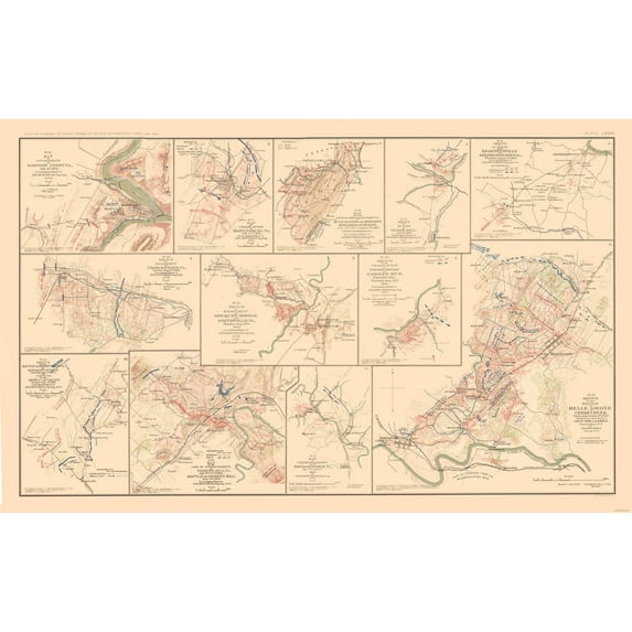
Civil War Maps - Battle Positions - Virginia - West Virginia - Lamont 1894 - This is an exquisite full-color Reproduction printed on high-quality gloss paper, art paper or canvas.
Print Size: 23.00 x 36.89 inches
58.42 X 93.70cm
The following towns are featured: Berryville, Charlestown, Harper's Ferry, Martinsburg, Kearneysville, Cooney Run, Belle Grove, Bridgewater, Fishers Hill, Middletown.
This Map is Situated in: Virginia, West Virginia.
SKU: CWVA0017
Original Maps are often difficult to find and usually have fold lines, identifying stamps or markings, tears, ragged edges, and assorted other natural signs of age that detract from their beauty. All of our maps have been professionally restored to depict their original beauty, while keeping all historical data intact.
These maps are fabulous pieces of history full of information useful to Historians, Genealogists, Cartographers, Relic Hunters, & Others. They make fascinating conversation pieces and splendid works of art for the home or office.
- MAP OF THE CIVIL WAR ERA UNITED STATES - Ever wonder what a certain state or region looked like during the Civil War? Now you can see for yourself and own a piece of USA history! We have maps of colonies, states, all the way up to the entire eastern half of North America. Our maps date all the way back to as early as the 1700's!
- GREAT COMPLIMENT TO ANY COLLECTION - If you are a Civil war-buff, then you likely own a number of pieces of memorabelia from that era. Some items may be replica's, and if you are lucky, some items are originals. A beautiful map from the Civil War era is a great compliment to any collection and adds a finishing touch to collection rooms!
- ONLY ACCEPT THE BEST PRINT QUALITY FOR YOUR REPRODUCTIONS - There are many printers and print types available on the market, when purchasing a reproduction there is no finer quality reproduction than a reproduction using the Giclee Printing method. Giclee describes the technique or style of printing used, and it is revered as the highest quality printing because of the way it precisely sprays ink onto a surface. Trust nothing less than the best!
- GUARNANTEED TO GET EXACTLY WHAT YOU ORDERED - This map comes exactly to the specification of 23.00 x 36.89 inches/58.42 X 93.70 cm. All of our maps come rolled, wrapped, and shipped in a heavy gauge mailing tube to ensure it arrives intact.
- WHY CHOOSE MAPS OF THE PAST? - Maps of the Past is one of the single largest producers of different types of maps. They legally own the rights to the maps they sell, and provide them to you in clean, clear, and vibrant print. If you are looking for a high quality map print, then look no further than Maps of the Past!
info:
We aim to show you accurate product information. Manufacturers, suppliers and others provide what you see here, and we have not verified it.
Specifications
Size
23.00 x 36.89
Material
Glossy Satin Photo Quality
Decor style
Vintage
Theme
Civil War Maps
Warranty
Warranty information
Please be aware that the warranty terms on items offered for sale by third party Marketplace sellers may differ from those displayed in this section (if any). To confirm warranty terms on an item offered for sale by a third party Marketplace seller, please use the 'Contact seller' feature on the third party Marketplace seller's information page and request the item's warranty terms prior to purchase.
Customer ratings & reviews
0 ratings|0 reviews
This item does not have any reviews yet

Related pages
- Gettysburg Pennsylvania Map
- Gettysburg National Park Map
- Washington Dc Aerial
- North Alabama Maps
- Shiloh Civil War Map
- Constitution Wall Art
- National Parks Posters
- Central America Travel Books, Maps & Guides
- Midwest United States Travel Books, Maps & Guides
- Western United States Travel Books, Maps & Guides
- General South America Travel Books, Maps & Guides
- Northeast United States Travel Books, Maps & Guides