

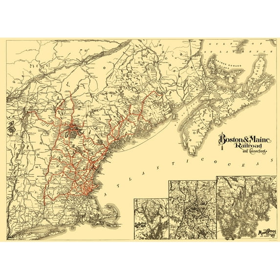
Hero image 0 of Railroad Map - Boston and Maine Railroad - Avery 1888 - 23 x 31.51 - Vintage Wall Art, 0 of 5
Railroad Map - Boston and Maine Railroad - Avery 1888 - 23 x 31.51 - Vintage Wall Art
(No ratings yet)
Key item features
- WHAT IS A RAILROAD SYSTEM? - Railroad systems were the original means of transporting both goods and people across the US, and many other countries across the globe. Railroads were built beginning in the 1800's and grew rapidly. They span coast to coast and are still heavily used today in many countries.
- ARE YOU A RAILROAD ENTHUSIAST? - If so, then add to your collection with prints of the original mappings of the railroad systems. Compare it against what is present today and see how much or how little it has changed since it's inceptions likely more than 100 years ago.
- ONLY ACCEPT THE BEST PRINT QUALITY FOR YOUR REPRODUCTIONS - There are many printers and print types available on the market, when purchasing a reproduction there is no finer quality reproduction than a reproduction using the Giclee Printing method. Giclee describes the technique or style of printing used, and it is revered as the highest quality printing because of the way it precisely sprays ink onto a surface. Trust nothing less than the best!
- GUARNANTEED TO GET EXACTLY WHAT YOU ORDERED - This map comes exactly to the specification of 23.00 x 31.51 inches/58.42 X 80.03 cm. All of our maps come rolled, wrapped, and shipped in a heavy gauge mailing tube to ensure it arrives intact.
- WHY CHOOSE MAPS OF THE PAST? - Maps of the Past is one of the single largest producers of different types of maps. They legally own the rights to the maps they sell, and provide them to you in clean, clear, and vibrant print. If you are looking for a high quality map print, then look no further than Maps of the Past!
Specs
- Size23.00 x 31.51
- MaterialMatte Art
- Decor styleVintage
- ThemeOld Railroad Maps
- ShapeRectangle
- Art typePainting
Current price is USDNow $45.95
You save $29.00
was $74.95$74.95
$45.95/countYou save$29.00
Price when purchased online
- Free shipping
Free 30-day returns
How do you want your item?
Columbus, 43215
Arrives between Feb 27 - Mar 2
|Sold and shipped by Maps of the Past
4.3 stars out of 5, based on 10 seller reviews(4.3)10 seller reviews
Free 30-day returns
Compare with similar items
| Product | Viewing this itemRailroad Map - Boston and Maine Railroad - Avery 1888 - 23 x 31.51 - Vintage Wall Art ![]() Now $45.95 current price Now $45.95, Was $74.95$74.95 | Railroad Map - New York City IRT Routes - 1924 - 23 x 39.01 - Vintage Wall Art ![]() Now $45.95 current price Now $45.95, Was $74.95$74.95 | Railroad Map - United States Canada Railroads Telegraph - Lloyd 1867 - 23 x 31 - Vintage Wall Art ![]() Now $45.95 current price Now $45.95, Was $74.95$74.95 | Railroad Map - Seaboard Pennsylvania and Western Railroad - Colton 1884 - 23 x 26 - Vintage Wall Art ![]() Now $45.95 current price Now $45.95, Was $74.95$74.95 | Railroad Map - Evansville and Crawfordsville Railroad - Lellan 1850 - 23 x 51 - Vintage Wall Art ![]() Now $45.95 current price Now $45.95, Was $74.95$74.95 | Historic Revolutionary War Map - Boston Harbour Environs - Page 1775 - 23 x 31.34 - Vintage Wall Art ![]() Now $45.95 current price Now $45.95, Was $74.95$74.95 | Railroad Map - Chicago Rock Island and Pacific Railroad 1879 - 23 x 46 - Vintage Wall Art ![]() Now $45.95 current price Now $45.95, Was $74.95$74.95 | Railroad Map - Nebraska Railroad Townships - Cram 1875 - 23 x 32.39 - Vintage Wall Art ![]() Now $45.95 current price Now $45.95, Was $74.95$74.95 | Historic City Map - Natchez Mississippi - Collot 1796 - 23 x 31.60 - Vintage Wall Art ![]() Now $45.95 current price Now $45.95, Was $74.95$74.95 | Historic City Map - Boston Massachusetts - Castle 1841 - 29.06 x 23 - Vintage Wall Art ![]() Now $45.95 current price Now $45.95, Was $74.95$74.95 |
|---|
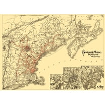
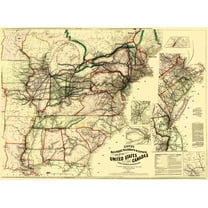
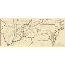
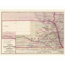
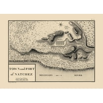
| Size | 23.00 x 31.51Railroad Map - Boston and Maine Railroad - Avery 1888 - 23 x 31.51 - Vintage Wall Art | 23.00 x 39.01Railroad Map - New York City IRT Routes - 1924 - 23 x 39.01 - Vintage Wall Art | 23.00 x 31.15Railroad Map - United States Canada Railroads Telegraph - Lloyd 1867 - 23 x 31 - Vintage Wall Art | 23.00 x 26.67Railroad Map - Seaboard Pennsylvania and Western Railroad - Colton 1884 - 23 x 26 - Vintage Wall Art | 23.00 x 51.29Railroad Map - Evansville and Crawfordsville Railroad - Lellan 1850 - 23 x 51 - Vintage Wall Art | 23.00 x 32.05Historic Revolutionary War Map - Boston Harbour Environs - Page 1775 - 23 x 31.34 - Vintage Wall Art | 23.00 x 46.18Railroad Map - Chicago Rock Island and Pacific Railroad 1879 - 23 x 46 - Vintage Wall Art | 23.00 x 32.39Railroad Map - Nebraska Railroad Townships - Cram 1875 - 23 x 32.39 - Vintage Wall Art | 23.00 x 31.60Historic City Map - Natchez Mississippi - Collot 1796 - 23 x 31.60 - Vintage Wall Art | 29.06 x 23Historic City Map - Boston Massachusetts - Castle 1841 - 29.06 x 23 - Vintage Wall Art |
|---|---|---|---|---|---|---|---|---|---|---|
| Material | Matte ArtRailroad Map - Boston and Maine Railroad - Avery 1888 - 23 x 31.51 - Vintage Wall Art | Matte ArtRailroad Map - New York City IRT Routes - 1924 - 23 x 39.01 - Vintage Wall Art | Matte ArtRailroad Map - United States Canada Railroads Telegraph - Lloyd 1867 - 23 x 31 - Vintage Wall Art | Matte ArtRailroad Map - Seaboard Pennsylvania and Western Railroad - Colton 1884 - 23 x 26 - Vintage Wall Art | Matte ArtRailroad Map - Evansville and Crawfordsville Railroad - Lellan 1850 - 23 x 51 - Vintage Wall Art | Matte ArtHistoric Revolutionary War Map - Boston Harbour Environs - Page 1775 - 23 x 31.34 - Vintage Wall Art | Matte ArtRailroad Map - Chicago Rock Island and Pacific Railroad 1879 - 23 x 46 - Vintage Wall Art | Matte ArtRailroad Map - Nebraska Railroad Townships - Cram 1875 - 23 x 32.39 - Vintage Wall Art | Matte ArtHistoric City Map - Natchez Mississippi - Collot 1796 - 23 x 31.60 - Vintage Wall Art | Matte ArtHistoric City Map - Boston Massachusetts - Castle 1841 - 29.06 x 23 - Vintage Wall Art |
| Decor style | VintageRailroad Map - Boston and Maine Railroad - Avery 1888 - 23 x 31.51 - Vintage Wall Art | VintageRailroad Map - New York City IRT Routes - 1924 - 23 x 39.01 - Vintage Wall Art | VintageRailroad Map - United States Canada Railroads Telegraph - Lloyd 1867 - 23 x 31 - Vintage Wall Art | VintageRailroad Map - Seaboard Pennsylvania and Western Railroad - Colton 1884 - 23 x 26 - Vintage Wall Art | -Railroad Map - Evansville and Crawfordsville Railroad - Lellan 1850 - 23 x 51 - Vintage Wall Art | VintageHistoric Revolutionary War Map - Boston Harbour Environs - Page 1775 - 23 x 31.34 - Vintage Wall Art | VintageRailroad Map - Chicago Rock Island and Pacific Railroad 1879 - 23 x 46 - Vintage Wall Art | VintageRailroad Map - Nebraska Railroad Townships - Cram 1875 - 23 x 32.39 - Vintage Wall Art | VintageHistoric City Map - Natchez Mississippi - Collot 1796 - 23 x 31.60 - Vintage Wall Art | VintageHistoric City Map - Boston Massachusetts - Castle 1841 - 29.06 x 23 - Vintage Wall Art |
| Theme | Old Railroad MapsRailroad Map - Boston and Maine Railroad - Avery 1888 - 23 x 31.51 - Vintage Wall Art | Old Railroad MapsRailroad Map - New York City IRT Routes - 1924 - 23 x 39.01 - Vintage Wall Art | Old Railroad MapsRailroad Map - United States Canada Railroads Telegraph - Lloyd 1867 - 23 x 31 - Vintage Wall Art | Old Railroad MapsRailroad Map - Seaboard Pennsylvania and Western Railroad - Colton 1884 - 23 x 26 - Vintage Wall Art | Old Railroad MapsRailroad Map - Evansville and Crawfordsville Railroad - Lellan 1850 - 23 x 51 - Vintage Wall Art | Revolutionary War MapsHistoric Revolutionary War Map - Boston Harbour Environs - Page 1775 - 23 x 31.34 - Vintage Wall Art | Old Railroad MapsRailroad Map - Chicago Rock Island and Pacific Railroad 1879 - 23 x 46 - Vintage Wall Art | Old Railroad MapsRailroad Map - Nebraska Railroad Townships - Cram 1875 - 23 x 32.39 - Vintage Wall Art | Historical City MapsHistoric City Map - Natchez Mississippi - Collot 1796 - 23 x 31.60 - Vintage Wall Art | Historical City MapsHistoric City Map - Boston Massachusetts - Castle 1841 - 29.06 x 23 - Vintage Wall Art |
Now hiding additional rows in the Table
About this item
Product details
Old Railroad Map - Boston and Maine Railroad - Avery 1888 - This is an exquisite full-color Reproduction printed on high-quality gloss paper, art paper or canvas.
Print Size: 23.00 x 31.51 inches
58.42 X 80.03cm
Sites and Townships Specific To This Map Are: Boston, Ports Mouth, Bangor, Battleboro, North Hampton, Worcester, Springfield, Farmington, Burnham, Eastport and many more.
The following towns are featured: This map shows the Boston and Maine Railroad with its numerous connections. The railroad and its connecting lines are shown in red and span over four states. Notable features include: St. Lawrence River, Rangely Lakes, Sebago Lake, Cape Cod Bay, Nantucket Sound, Bay of Fundy, Isles of Shoals and many mountains. In the bottom left corner are expanded views of St. Andrews N. B., White Mountain Range and Mount Desert Island.
This Map is Situated in: Northeast United Sates (USA).
SKU: MARR0002
Original Maps are often difficult to find and usually have fold lines, identifying stamps or markings, tears, ragged edges, and assorted other natural signs of age that detract from their beauty. All of our maps have been professionally restored to depict their original beauty, while keeping all historical data intact.
These maps are fabulous pieces of history full of information useful to Historians, Genealogists, Cartographers, Relic Hunters, & Others. They make fascinating conversation pieces and splendid works of art for the home or office.
- WHAT IS A RAILROAD SYSTEM? - Railroad systems were the original means of transporting both goods and people across the US, and many other countries across the globe. Railroads were built beginning in the 1800's and grew rapidly. They span coast to coast and are still heavily used today in many countries.
- ARE YOU A RAILROAD ENTHUSIAST? - If so, then add to your collection with prints of the original mappings of the railroad systems. Compare it against what is present today and see how much or how little it has changed since it's inceptions likely more than 100 years ago.
- ONLY ACCEPT THE BEST PRINT QUALITY FOR YOUR REPRODUCTIONS - There are many printers and print types available on the market, when purchasing a reproduction there is no finer quality reproduction than a reproduction using the Giclee Printing method. Giclee describes the technique or style of printing used, and it is revered as the highest quality printing because of the way it precisely sprays ink onto a surface. Trust nothing less than the best!
- GUARNANTEED TO GET EXACTLY WHAT YOU ORDERED - This map comes exactly to the specification of 23.00 x 31.51 inches/58.42 X 80.03 cm. All of our maps come rolled, wrapped, and shipped in a heavy gauge mailing tube to ensure it arrives intact.
- WHY CHOOSE MAPS OF THE PAST? - Maps of the Past is one of the single largest producers of different types of maps. They legally own the rights to the maps they sell, and provide them to you in clean, clear, and vibrant print. If you are looking for a high quality map print, then look no further than Maps of the Past!
info:
We aim to show you accurate product information. Manufacturers, suppliers and others provide what you see here, and we have not verified it.
Specifications
Size
23.00 x 31.51
Material
Matte Art
Decor style
Vintage
Theme
Old Railroad Maps
Warranty
Warranty information
Please be aware that the warranty terms on items offered for sale by third party Marketplace sellers may differ from those displayed in this section (if any). To confirm warranty terms on an item offered for sale by a third party Marketplace seller, please use the 'Contact seller' feature on the third party Marketplace seller's information page and request the item's warranty terms prior to purchase.
Similar items you might like
Based on what customers bought
Railroad Map - New York City IRT Routes - 1924 - 23 x 39.01 - Vintage Wall Art $45.95 Was $74.95
3 optionsAvailable in additional 3 optionsNow$4595current price Now $45.95, Was $74.95$74.95You save $29.00You save$29.00More options from $40.95Railroad Map - New York City IRT Routes - 1924 - 23 x 39.01 - Vintage Wall Art
Shipping, arrives in 3+ daysRailroad Map - United States Canada Railroads Telegraph - Lloyd 1867 - 23 x 31 - Vintage Wall Art $45.95 Was $74.95
3 optionsAvailable in additional 3 optionsNow$4595current price Now $45.95, Was $74.95$74.95You save $29.00You save$29.00More options from $40.95Railroad Map - United States Canada Railroads Telegraph - Lloyd 1867 - 23 x 31 - Vintage Wall Art
Shipping, arrives in 3+ daysRailroad Map - Seaboard Pennsylvania and Western Railroad - Colton 1884 - 23 x 26 - Vintage Wall Art $45.95 Was $74.95
3 optionsAvailable in additional 3 optionsNow$4595current price Now $45.95, Was $74.95$74.95You save $29.00You save$29.00More options from $40.95Railroad Map - Seaboard Pennsylvania and Western Railroad - Colton 1884 - 23 x 26 - Vintage Wall Art
Shipping, arrives in 3+ daysRailroad Map - Evansville and Crawfordsville Railroad - Lellan 1850 - 23 x 51 - Vintage Wall Art $45.95 Was $74.95
3 optionsAvailable in additional 3 optionsNow$4595current price Now $45.95, Was $74.95$74.95You save $29.00You save$29.00More options from $40.95Railroad Map - Evansville and Crawfordsville Railroad - Lellan 1850 - 23 x 51 - Vintage Wall Art
Shipping, arrives in 3+ daysHistoric Revolutionary War Map - Boston Harbour Environs - Page 1775 - 23 x 31.34 - Vintage Wall Art $45.95 Was $74.95
3 optionsAvailable in additional 3 optionsNow$4595current price Now $45.95, Was $74.95$74.95You save $29.00You save$29.00More options from $40.95Historic Revolutionary War Map - Boston Harbour Environs - Page 1775 - 23 x 31.34 - Vintage Wall Art
Railroad Map - Chicago Rock Island and Pacific Railroad 1879 - 23 x 46 - Vintage Wall Art $45.95 Was $74.95
3 optionsAvailable in additional 3 optionsNow$4595current price Now $45.95, Was $74.95$74.95You save $29.00You save$29.00More options from $40.95Railroad Map - Chicago Rock Island and Pacific Railroad 1879 - 23 x 46 - Vintage Wall Art
Shipping, arrives in 3+ daysRailroad Map - Nebraska Railroad Townships - Cram 1875 - 23 x 32.39 - Vintage Wall Art $45.95 Was $74.95
3 optionsAvailable in additional 3 optionsNow$4595current price Now $45.95, Was $74.95$74.95You save $29.00You save$29.00More options from $40.95Railroad Map - Nebraska Railroad Townships - Cram 1875 - 23 x 32.39 - Vintage Wall Art
Shipping, arrives in 3+ daysHistoric City Map - Natchez Mississippi - Collot 1796 - 23 x 31.60 - Vintage Wall Art $45.95 Was $74.95
3 optionsAvailable in additional 3 optionsNow$4595current price Now $45.95, Was $74.95$74.95You save $29.00You save$29.00More options from $40.95Historic City Map - Natchez Mississippi - Collot 1796 - 23 x 31.60 - Vintage Wall Art
Shipping, arrives in 3+ daysHistoric City Map - Boston Massachusetts - Castle 1841 - 29.06 x 23 - Vintage Wall Art $45.95 Was $74.95
3 optionsAvailable in additional 3 optionsNow$4595current price Now $45.95, Was $74.95$74.95You save $29.00You save$29.00More options from $40.95Historic City Map - Boston Massachusetts - Castle 1841 - 29.06 x 23 - Vintage Wall Art
Shipping, arrives in 3+ daysHistoric City Map - Hardy Ohio - Cring 1875 - 23 x 25.21 - Vintage Wall Art $45.95 Was $74.95
3 optionsAvailable in additional 3 optionsNow$4595current price Now $45.95, Was $74.95$74.95You save $29.00You save$29.00More options from $40.95Historic City Map - Hardy Ohio - Cring 1875 - 23 x 25.21 - Vintage Wall Art
Shipping, arrives in 3+ daysHistoric Map - California Island - De Fer 1720 - 23 x 33.05 - Vintage Wall Art $45.95 Was $74.95
3 optionsAvailable in additional 3 optionsNow$4595current price Now $45.95, Was $74.95$74.95You save $29.00You save$29.00More options from $40.95Historic Map - California Island - De Fer 1720 - 23 x 33.05 - Vintage Wall Art
Shipping, arrives in 3+ daysRailroad Map - Denver Texas and Ft Worth Railroad - Northrup 1888 - 23 x 33 - Vintage Wall Art $45.95 Was $74.95
3 optionsAvailable in additional 3 optionsNow$4595current price Now $45.95, Was $74.95$74.95You save $29.00You save$29.00More options from $40.95Railroad Map - Denver Texas and Ft Worth Railroad - Northrup 1888 - 23 x 33 - Vintage Wall Art
Shipping, arrives in 3+ daysRailroad Map - Illinois Railways - Cooke 1855 - 23 x 29.20 - Vintage Wall Art $45.95 Was $74.95
3 optionsAvailable in additional 3 optionsNow$4595current price Now $45.95, Was $74.95$74.95You save $29.00You save$29.00More options from $40.95Railroad Map - Illinois Railways - Cooke 1855 - 23 x 29.20 - Vintage Wall Art
Shipping, arrives in 3+ daysRailroad Map - Baltimore and Ohio Railroad Connections - Weber 1840 - 23 x 27 - Vintage Wall Art $45.95 Was $74.95
3 optionsAvailable in additional 3 optionsNow$4595current price Now $45.95, Was $74.95$74.95You save $29.00You save$29.00More options from $40.95Railroad Map - Baltimore and Ohio Railroad Connections - Weber 1840 - 23 x 27 - Vintage Wall Art
Shipping, arrives in 3+ daysHistoric State Map - New York - Lucas 1823 - 32 x 23 - Vintage Wall Art $45.95 Was $74.95
3 optionsAvailable in additional 3 optionsNow$4595current price Now $45.95, Was $74.95$74.95You save $29.00You save$29.00More options from $40.95Historic State Map - New York - Lucas 1823 - 32 x 23 - Vintage Wall Art
Shipping, arrives in 3+ daysHistoric City Map - Middleport Hartford Brownsville Ohio West Virginia - Hayes 1877 - 23x34 - Vintage Wall Art $45.95 Was $74.95
3 optionsAvailable in additional 3 optionsNow$4595current price Now $45.95, Was $74.95$74.95You save $29.00You save$29.00More options from $40.95Historic City Map - Middleport Hartford Brownsville Ohio West Virginia - Hayes 1877 - 23x34 - Vintage Wall Art
Shipping, arrives in 3+ daysHistoric Mine Map - Calaveras County California Mines - Walkup 1845 - 29 x 23 - Vintage Wall Art $45.95 Was $74.95
3 optionsAvailable in additional 3 optionsNow$4595current price Now $45.95, Was $74.95$74.95You save $29.00You save$29.00More options from $40.95Historic Mine Map - Calaveras County California Mines - Walkup 1845 - 29 x 23 - Vintage Wall Art
Shipping, arrives in 3+ daysHistoric City Map - Tuscarawas Ohio - Lawrence 1896 - 23 x 31.14 - Vintage Wall Art $45.95 Was $74.95
3 optionsAvailable in additional 3 optionsNow$4595current price Now $45.95, Was $74.95$74.95You save $29.00You save$29.00More options from $40.95Historic City Map - Tuscarawas Ohio - Lawrence 1896 - 23 x 31.14 - Vintage Wall Art
Historic County Map - Herkimer County New York - Burr 1829 - 23 x 58.31 - Vintage Wall Art $45.95 Was $74.95
3 optionsAvailable in additional 3 optionsNow$4595current price Now $45.95, Was $74.95$74.95You save $29.00You save$29.00More options from $40.95Historic County Map - Herkimer County New York - Burr 1829 - 23 x 58.31 - Vintage Wall Art
Shipping, arrives in 3+ daysRailroad Map - California Railroads 1883 - 23 x 26 - Vintage Wall Art $45.95 Was $74.95
3 optionsAvailable in additional 3 optionsNow$4595current price Now $45.95, Was $74.95$74.95You save $29.00You save$29.00More options from $40.95Railroad Map - California Railroads 1883 - 23 x 26 - Vintage Wall Art
Shipping, arrives in 3+ days
Popular items in this category
Best selling items that customers love
New York Subway Map 1948 Art Print - 11x14 Unframed Art Print - Great Vintage Home Decor $14.99
$1499current price $14.99New York Subway Map 1948 Art Print - 11x14 Unframed Art Print - Great Vintage Home Decor
Shipping, arrives in 3+ days1845 Map of Maine Art Print - 11x14 Unframed Art Print - Great Vintage Home Decor $14.99
$1499current price $14.991845 Map of Maine Art Print - 11x14 Unframed Art Print - Great Vintage Home Decor
Shipping, arrives in 3+ daysTexas Map Houston and Texas Central Railroad Art Print - 11x14 Unframed Art Print - Great Vintage Home Decor $14.99
$1499current price $14.99Texas Map Houston and Texas Central Railroad Art Print - 11x14 Unframed Art Print - Great Vintage Home Decor
Shipping, arrives in 3+ daysTrademark Fine Art Masters Fine Art USA License Plate Map on Wood Canvas Wall Art - 14x19 $32.95
4 optionsAvailable in additional 4 options$3295current price $32.95Options from $32.95 – $99.95Trademark Fine Art Masters Fine Art USA License Plate Map on Wood Canvas Wall Art - 14x19
15 out of 5 Stars. 1 reviewsShipping, arrives in 3+ daysNorth Carolina Map - 11x14 Unframed Art Print - Great Vintage Gift and Decor for History Buffs and Old Map Enthusiasts Under $15 $14.99
$1499current price $14.99North Carolina Map - 11x14 Unframed Art Print - Great Vintage Gift and Decor for History Buffs and Old Map Enthusiasts Under $15
Shipping, arrives in 3+ daysRollback Drsoum Vintage Flower Wall Art Poppies Floral Classic Wall Prints Modern Farmhouse Bedroom Living room Hallway Decor 12x12in Brown Framed $8.54 Was $10.59
SponsoredNow$854current price Now $8.54, Was $10.59$10.59You save $2.05You save$2.05Options from $8.54 – $55.99Drsoum Vintage Flower Wall Art Poppies Floral Classic Wall Prints Modern Farmhouse Bedroom Living room Hallway Decor 12x12in Brown Framed
2084.5 out of 5 Stars. 208 reviewsSave withShipping, arrives tomorrowNautical Vintage Titanic Vinolia Soap Ad Hanging Wooden Sign Bathroom Wall Art Home Decor $12.64
$1264current price $12.64+$3.32 shippingNautical Vintage Titanic Vinolia Soap Ad Hanging Wooden Sign Bathroom Wall Art Home Decor
Shipping, arrives in 3+ daysNorthlight Patriotic “Proud to be an American” Wooden USA Map Wall Art - 15.75” x 12” $18.99
$1899current price $18.99Northlight Patriotic “Proud to be an American” Wooden USA Map Wall Art - 15.75” x 12”
Shipping, arrives in 3+ daysMap of Florida 1855 Art Print - 11x14 Unframed Art Print - Great Vintage Home Decor $14.99
$1499current price $14.99Map of Florida 1855 Art Print - 11x14 Unframed Art Print - Great Vintage Home Decor
Shipping, arrives in 3+ daysOhio is My Home Vintage Chic Wall Decor 6x18 Metal Sign 106180025034 $29.95
$2995current price $29.95Ohio is My Home Vintage Chic Wall Decor 6x18 Metal Sign 106180025034
Shipping, arrives in 3+ daysBuffalo, NY City Sign Rustic Vintage Metal Art Wall Decor Office/Home/Classroom 4" x 16" $10.99
$1099current price $10.99Buffalo, NY City Sign Rustic Vintage Metal Art Wall Decor Office/Home/Classroom 4" x 16"
Shipping, arrives in 3+ daysMadison Park Royal Cat Portrait Renaissance Style Framed Canvas Wall Art, King Charles, 16.5"W x 20.5"H $12.79
6 optionsAvailable in additional 6 options$1279current price $12.79Madison Park Royal Cat Portrait Renaissance Style Framed Canvas Wall Art, King Charles, 16.5"W x 20.5"H
304.9 out of 5 Stars. 30 reviewsSave withShipping, arrives in 2 daysAmerican Art Decor Licensed Corona Brown Wood Tones Surfboard Plaque Wall Decor - 60"x15" $129.99
15 optionsAvailable in additional 15 options$12999current price $129.99More options from $49.99American Art Decor Licensed Corona Brown Wood Tones Surfboard Plaque Wall Decor - 60"x15"
74.6 out of 5 Stars. 7 reviewsShipping, arrives in 3+ days1818 Map of Washington DC Art Print - 11x14 Unframed Art Print - Great Vintage Home Decor $14.99
$1499current price $14.991818 Map of Washington DC Art Print - 11x14 Unframed Art Print - Great Vintage Home Decor
Shipping, arrives in 3+ daysVintage Kitchen By Trendy Decor4U Printed Wall Art Wood Multi-Color $54.32
$5432current price $54.32Vintage Kitchen By Trendy Decor4U Printed Wall Art Wood Multi-Color
Shipping, arrives in 3+ daysTrademark Fine Art John Constable Salisbury cathedral Canvas Wall Art - 14x19 $21.65 Was $29.95
4 optionsAvailable in additional 4 optionsNow$2165current price Now $21.65, Was $29.95$29.95You save $8.30You save$8.30Options from $21.65 – $69.95Trademark Fine Art John Constable Salisbury cathedral Canvas Wall Art - 14x19
Save withShipping, arrives tomorrowBeach Pathway Canvas Wall Art - Ocean Theme Artwork Boardwalk Picture with Wood Toned Fence and Weeds Painting for Living Room (20 x 16in) $26.50
2 optionsAvailable in additional 2 options$2650current price $26.50Beach Pathway Canvas Wall Art - Ocean Theme Artwork Boardwalk Picture with Wood Toned Fence and Weeds Painting for Living Room (20 x 16in)
Shipping, arrives in 3+ daysMy Texas House The Singel Canal Framed Wall Art 36x18 $42.00
$4200current price $42.00My Texas House The Singel Canal Framed Wall Art 36x18
144.2 out of 5 Stars. 14 reviewsSave withShipping, arrives in 3+ days
Customer ratings & reviews
0 ratings|0 reviews
This item does not have any reviews yet
Related pages
- Old Railroad Maps Michigan
- Tennessee Railroad Maps
- Chicago Bus Map
- Texas Railroad Map
- Bus Maps Nyc
- Train Map Chicago
- National Parks Posters
- Central America Travel Books, Maps & Guides
- Midwest United States Travel Books, Maps & Guides
- Northeast United States Travel Books, Maps & Guides
- General South America Travel Books, Maps & Guides
- Western United States Travel Books, Maps & Guides


