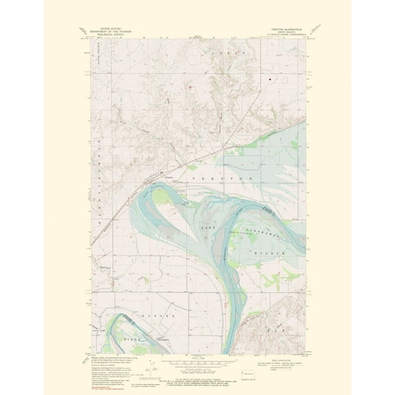
Hero image 0 of Topographical Map - Trenton North Dakota Quad - USGS 1976 - Vintage Wall Art, 0 of 4
Topographical Map - Trenton North Dakota Quad - USGS 1976 - Vintage Wall Art
(No ratings yet)
Topographical Map - Trenton North Dakota Quad - USGS 1976 - Vintage Wall ArtTopographical Map Trenton North Dakota Quad USGS 1976 23 x 29 54 Vintage Wall ArtTopographical Map Trenton North Dakota Quad USGS 1976 23 x 29 54 Vintage Wall ArtTopographical Map Trenton North Dakota Quad USGS 1976 Vintage Wall ArtTopographical Map Trenton North Dakota Quad USGS 1976 Vintage Wall Art
Material:Matte Art
Size:23.00 x 29.54
Key item features
- OWN A HISTORICAL TOPOGRAPHICAL MAP TODAY - Topographical maps provide you a birds-eye view of how the topography of certain pieces of land are mapped out. See how much today's maps have changed from centuries ago. See how waterways have shifted, or how forrests have become thralling cities. See how history has changed the landscape with a topographical map today!
- TOPOGRAPHICAL MAPS PROVIDE IMPORTANT INFORMATION -Topographical maps show you how the borders of a county are established and were they can be found. It also highlights rivers, mountains, and other natural elements, and it will show you where the cities are located within it.
- ONLY ACCEPT THE BEST PRINT QUALITY FOR YOUR REPRODUCTIONS - There are many printers and print types available on the market, when purchasing a reproduction there is no finer quality reproduction than a reproduction using the Giclee Printing method. Giclee describes the technique or style of printing used, and it is revered as the highest quality printing because of the way it precisely sprays ink onto a surface. Trust nothing less than the best!
- GUARANTEED TO GET EXACTLY WHAT YOU ORDERED - All of our maps come rolled, wrapped, and shipped in a heavy gauge mailing tube to ensure it arrives intact.
- WHY CHOOSE MAPS OF THE PAST? - Maps of the Past is one of the single largest producers of different types of maps. They legally own the rights to the maps they sell, and provide them to you in clean, clear, and vibrant print. If you are looking for a high quality map print, then look no further than Maps of the Past!
Specs
 BrandMAPS OF THE PAST
 ColorMulticolor
 Age groupAdult
Current price is USD$45.95$45.95/count
Price when purchased online
- Free shipping
 Free 30-day returns
How do you want your item?
Columbus, 43215
Arrives between May 9 - May 11
|Sold and shipped by Maps of the Past
4.363636363636363 stars out of 5, based on 11 seller reviews(4.4)11 seller reviews
Free 30-day returns - in store or online
About this item
Product details
Historical Topographic Maps - Trenton North Dakota Quad - USGS 1976 - This is an exquisite full-color Reproduction printed on gloss paper or art paper.
The following towns are featured: Trenton.
This Map is Situated in: Trenton, North Dakota.
SKU: NDTR0001
Original Maps are often difficult to find and usually have fold lines, identifying stamps or markings, tears, ragged edges, and assorted other natural signs of age that detract from their beauty. All of our maps have been professionally restored to depict their original beauty, while keeping all historical data intact.
These maps are fabulous pieces of history full of information useful to Historians, Genealogists, Cartographers, Relic Hunters, & Others. They make fascinating conversation pieces and splendid works of art for the home or office.
- OWN A HISTORICAL TOPOGRAPHICAL MAP TODAY - Topographical maps provide you a birds-eye view of how the topography of certain pieces of land are mapped out. See how much today's maps have changed from centuries ago. See how waterways have shifted, or how forrests have become thralling cities. See how history has changed the landscape with a topographical map today!
- TOPOGRAPHICAL MAPS PROVIDE IMPORTANT INFORMATION -Topographical maps show you how the borders of a county are established and were they can be found. It also highlights rivers, mountains, and other natural elements, and it will show you where the cities are located within it.
- ONLY ACCEPT THE BEST PRINT QUALITY FOR YOUR REPRODUCTIONS - There are many printers and print types available on the market, when purchasing a reproduction there is no finer quality reproduction than a reproduction using the Giclee Printing method. Giclee describes the technique or style of printing used, and it is revered as the highest quality printing because of the way it precisely sprays ink onto a surface. Trust nothing less than the best!
- GUARANTEED TO GET EXACTLY WHAT YOU ORDERED - All of our maps come rolled, wrapped, and shipped in a heavy gauge mailing tube to ensure it arrives intact.
- WHY CHOOSE MAPS OF THE PAST? - Maps of the Past is one of the single largest producers of different types of maps. They legally own the rights to the maps they sell, and provide them to you in clean, clear, and vibrant print. If you are looking for a high quality map print, then look no further than Maps of the Past!
info:
We aim to show you accurate product information. Manufacturers, suppliers and others provide what you see here, and we have not verified it.
Specifications
Brand
MAPS OF THE PAST
Color
Multicolor
Age group
Adult
Warranty
Warranty information
Please be aware that the warranty terms on items offered for sale by third party Marketplace sellers may differ from those displayed in this section (if any). To confirm warranty terms on an item offered for sale by a third party Marketplace seller, please use the 'Contact seller' feature on the third party Marketplace seller's information page and request the item's warranty terms prior to purchase.
Similar items you might like
Based on what customers bought
Historic State Map - United States North Eastern Canada - Black 1867 - Vintage Wall Art $36.95
 4 optionsAvailable in additional 4 options$3695current price $36.95
Historic State Map - United States North Eastern Canada - Black 1867 - Vintage Wall Art
Topographical Map - Clark Brothers Ranch Texas Quad - USGS 1981 - Vintage Wall Art $36.95
 4 optionsAvailable in additional 4 options$3695current price $36.95
Topographical Map - Clark Brothers Ranch Texas Quad - USGS 1981 - Vintage Wall Art
Historic State Map - Alabama - Cram 1888 - Vintage Wall Art $36.95
 4 optionsAvailable in additional 4 options$3695current price $36.95
Historic State Map - Alabama - Cram 1888 - Vintage Wall Art
Historic State Map - Louisiana - Melish 1820 - Vintage Wall Art $36.95
 4 optionsAvailable in additional 4 options$3695current price $36.95
Historic State Map - Louisiana - Melish 1820 - Vintage Wall Art
Historic State Map - Nebraska Kansas - Colton 1855 - Vintage Wall Art $36.95
 4 optionsAvailable in additional 4 options$3695current price $36.95
Historic State Map - Nebraska Kansas - Colton 1855 - Vintage Wall Art
Historic State Map - South Carolina - Mitchell 1849 - Vintage Wall Art $36.95
 $3695current price $36.95
Historic State Map - South Carolina - Mitchell 1849 - Vintage Wall Art
Best seller 24x36 United States, USA, US Premier Wall Map Paper Folded $11.90
Best seller $1190current price $11.90
24x36 United States, USA, US Premier Wall Map Paper Folded
604.3 out of 5 Stars. 60 reviewsHistoric State Map - Texas Mexico - Carey 1822 - Vintage Wall Art $36.95
 $3695current price $36.95
Historic State Map - Texas Mexico - Carey 1822 - Vintage Wall Art
24"x32" Map of Connecticut with Counties and Towns 【Photo Paper】 $24.99
 4 optionsAvailable in additional 4 options$2499current price $24.99
24"x32" Map of Connecticut with Counties and Towns 【Photo Paper】
24x24in Nevada County Map with Cities 【Photo Paper】 $24.99
 2 optionsAvailable in additional 2 options$2499current price $24.99
24x24in Nevada County Map with Cities 【Photo Paper】
11 out of 5 Stars. 1 reviewsAlaska 3D Raised Relief Map $39.99
 $3999current price $39.99
Alaska 3D Raised Relief Map
California 3D Raised Relief Map $39.99
 $3999current price $39.99
California 3D Raised Relief Map
Xplorer Maps MAP_UT Utah State Hand-Drawn Map $37.26
 $3726current price $37.26
Xplorer Maps MAP_UT Utah State Hand-Drawn Map
Topographical Map - Bates Knolls Utah Quad - USGS 1966 - Vintage Wall Art $36.95
 $3695current price $36.95
Topographical Map - Bates Knolls Utah Quad - USGS 1966 - Vintage Wall Art
United States 3D Raised Relief Map $39.99
 $3999current price $39.99
United States 3D Raised Relief Map
Canada 3D Raised Relief Map $39.99
 $3999current price $39.99
Canada 3D Raised Relief Map
Hawaii 3D Raised Relief Map $39.99
 $3999current price $39.99
Hawaii 3D Raised Relief Map
Topographical Map - Carthage East Illinois Quad - USGS 1974 - Vintage Wall Art $36.95
 $3695current price $36.95
Topographical Map - Carthage East Illinois Quad - USGS 1974 - Vintage Wall Art
Texas State Wall Map Rolled (Laminated 24"x25") $38.88
 $3888current price $38.88
Texas State Wall Map Rolled (Laminated 24"x25")
RXMEKW United States Map 2,025 Map Update, Including U.S. Bay and Mckinley Mountain 12In*18In $7.00

 $700current price $7.00
RXMEKW United States Map 2,025 Map Update, Including U.S. Bay and Mckinley Mountain 12In*18In
Customer ratings & reviews
0 ratings|0 reviews
This item does not have any reviews yet
