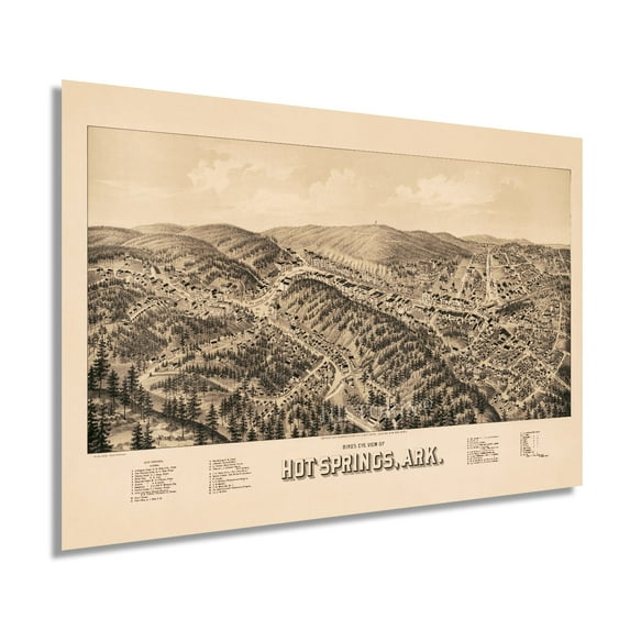
1888 Hot Springs Arkansas Map - Vintage Hot Springs Map Art - Bird's Eye View History Map of Hot Springs Arkansas - Old Map of Hot Springs AR Wall Art Poster
Key item features
- Size: 24 x 36 Inches
- Museum-quality giclee print
- Printed using archival ink on premium heavyweight acid-free matte paper
- Shipped in a sturdy cardboard tube
- Makes a perfect gift
Specs
- Size24 x 36
- ThemeVintage
- FramedN
- BrandHistoric Prints
- Photo paper finish configurationMatte
- Pieces1
- Free shipping
 Free 30-day returns
How do you want your item?
About this item
Product details
Feature Points
- VINTAGE MAP REPRODUCTION: You’ll love this high quality historic reproduction of 1888 Hot Springs Arkansas Map. Our museum quality maps are archival grade, which means it will look great and last without fading for over 100 years. Our print to order maps are made in the USA and each map is inspected for quality. This beautiful artwork is a perfect addition to your themed decor. Vintage maps look great in the home, study or office. They make a perfect gift as well.
- MUSEUM QUALITY: This high quality map print will be a great addition to your vintage-themed wall. Don't waste money on cheap-looking, thin paper posters. We use thick, fine art print quality matte paper. Our professional’s choice matte paper displays artwork in high detail without glare. The color is vibrant and text is easy to read. When framed, this map looks absolutely stunning.
- A LOOK BACK AT HISTORY: This is an impressive, historic reproduction of 1888 Hot Springs Vintage Map. A true piece of history. See our product description section for more fascinating information about this historic map and its significance.
- READY TO FRAME: This print includes a 0.2 inch border for a perfect frame fit and look. Our maps are designed to fit easy-to-find standard frame sizes, saving you money from having to pay for a custom frame. Each map is inspected for quality and shipped in a rigid tube.
- HISTORIX: We love history and art. Sometimes old maps have tears, folds, separations and other blemishes. We digitally restore and enhance maps while keeping its historical character. All our maps are proudly made in the USA. Customers all over the world love our vintage maps and we know you will too.
Additional Information
Produced and published by one of America’s most prolific cartographers, Henry Wellge, this unique depiction of Hot Springs, Arkansas, shows the city in a sort of renaissance. Many residents had fled during the Civil War, and roving bands with loose associations to both Union and Confederate forces destroyed much of the town, including the iconic bathhouses. By 1888 the city had been rebuilt and attracted year-round residents who established numerous hotels, businesses, and bathhouses.
Birdseye perspectives were among the most popular illustrations from the latter portion of the nineteenth century until the 1920s when aerial photography allowed what months of illustration work to be done in a single day. This distinction makes these rare pieces of cartographical history and a genuine link to the past. Their immediately recognizable aesthetic and unique style transports the viewer back in time and creates an indelible bond to the cities rich history.
The natural spring water is believed to have healing benefits and has drawn tourists since Hot Springs was incorporated in 1851. The completion of a narrow-gauge railroad in 1875 allowed expanded access to the city, and the population again increased while the rail line also promoted tourism. Home to Hot Springs National Park, the region’s natural beauty and rolling hills have long attracted tourists looking to escape the cold winter months in the North. Wellge’s depiction would have served as a promotional tool to attract residents and merchants alike by featuring notable civic features, buildings, and other attractions.
Our museum quality giclee print comes printed with archival ink on premium heavyweight matte paper. Shipped in a sturdy cardboard tube your print will arrive ready to be framed. This eye-catching vintage map reproduction print makes the perfect gift for anyone that loves history and imagery.
- Size: 24 x 36 Inches
- Museum-quality giclee print
- Printed using archival ink on premium heavyweight acid-free matte paper
- Shipped in a sturdy cardboard tube
- Makes a perfect gift
Specifications
Size
Theme
Framed
Brand
Warranty
Warranty information
Similar items you might like
Based on what customers bought
1879 New Haven Connecticut Map - Vintage New Haven Map - History of New Haven CT Poster - Bird's Eye View History Map of New Haven Connecticut Wall Art Poster $39.99
 2 optionsAvailable in additional 2 options$3999current price $39.99
1879 New Haven Connecticut Map - Vintage New Haven Map - History of New Haven CT Poster - Bird's Eye View History Map of New Haven Connecticut Wall Art Poster
Pennsylvania 1855 Vintage Map 11x14 Unframed Print – Antique Cartography Poster Reproduction Counties Rivers Railroads Towns Historical Keystone State Wall Art Rustic Décor for Home Office Classroom $14.99
 $1499current price $14.99
Pennsylvania 1855 Vintage Map 11x14 Unframed Print – Antique Cartography Poster Reproduction Counties Rivers Railroads Towns Historical Keystone State Wall Art Rustic Décor for Home Office Classroom
Bryce Canyon Poster: Vintage National Park Art - Utah Illustration Travel Poster Desert Nature Landscape Wilderness Scenic Vintage Poster Unframed Wall Art Print 4 x 6 inches $33.14
 12 optionsAvailable in additional 12 options$3314current price $33.14
Bryce Canyon Poster: Vintage National Park Art - Utah Illustration Travel Poster Desert Nature Landscape Wilderness Scenic Vintage Poster Unframed Wall Art Print 4 x 6 inches
1897 Asbury Park Ocean Grove New Jersey Map - Asbury Park Wall Art - Old Map of Asbury Park NJ Poster $39.99
 2 optionsAvailable in additional 2 options$3999current price $39.99
1897 Asbury Park Ocean Grove New Jersey Map - Asbury Park Wall Art - Old Map of Asbury Park NJ Poster
1879 Atascosa County Texas Map - Vintage Map of Atascosa County - Old Atascosa County Map - History Map of Atascosa County TX Showing Land Ownership Wall Art Poster $37.99
 2 optionsAvailable in additional 2 options$3799current price $37.99
1879 Atascosa County Texas Map - Vintage Map of Atascosa County - Old Atascosa County Map - History Map of Atascosa County TX Showing Land Ownership Wall Art Poster
1913 High Point North Carolina Map - Old High Point Map of NC Wall Art - High Point NC Map Poster History $39.99
 2 optionsAvailable in additional 2 options$3999current price $39.99
1913 High Point North Carolina Map - Old High Point Map of NC Wall Art - High Point NC Map Poster History
24"x36" Gallery Poster, civil war map Richmond (VA), Peterburg and Five Forks (VA), Bermuda Hundred (VA), Jetersville and Sailor's Creek ( $52.95
 $5295current price $52.95
24"x36" Gallery Poster, civil war map Richmond (VA), Peterburg and Five Forks (VA), Bermuda Hundred (VA), Jetersville and Sailor's Creek (
1961 Caribbean America Map - Vintage Caribbean Map - Old Caribbean America Map Wall Art Poster Print $39.99
 2 optionsAvailable in additional 2 options$3999current price $39.99
1961 Caribbean America Map - Vintage Caribbean Map - Old Caribbean America Map Wall Art Poster Print
HISTORIX 1890 Honesdale Pennsylvania Map Vintage Poster Wall Art Print, 24 x 36 Inch $39.99
 2 optionsAvailable in additional 2 options$3999current price $39.99
HISTORIX 1890 Honesdale Pennsylvania Map Vintage Poster Wall Art Print, 24 x 36 Inch
1909 Map of Colorado Springs - Vintage Map of Colorado Springs Wall Art Decor Print Poster - Panoramic Birds Eye View of Colorado Springs with Points of Interest $39.99
 2 optionsAvailable in additional 2 options$3999current price $39.99
1909 Map of Colorado Springs - Vintage Map of Colorado Springs Wall Art Decor Print Poster - Panoramic Birds Eye View of Colorado Springs with Points of Interest
Oklahoma 1912 Vintage Map 11x14 Unframed Print–Antique Cartography Poster Reproduction with Counties Rivers Railroads Towns Historical Wall Art Rustic Sooner State Décor for Home Office Library Study $14.99
 $1499current price $14.99
Oklahoma 1912 Vintage Map 11x14 Unframed Print–Antique Cartography Poster Reproduction with Counties Rivers Railroads Towns Historical Wall Art Rustic Sooner State Décor for Home Office Library Study
Vintage 1888 Saratoga Springs New York Map Old Saratoga Springs NY Wall Art - History Map of Saratoga Springs New York Poster $17.51
 2 optionsAvailable in additional 2 options$1751current price $17.51
Vintage 1888 Saratoga Springs New York Map Old Saratoga Springs NY Wall Art - History Map of Saratoga Springs New York Poster
New Mexico and Arizona 1875 Vintage Map 11x14 Unframed Print–Antique Gray’s Atlas Poster Historical Cartography Reproduction w/Counties Railroads Towns Wall Art Rustic Southwest Decor for Home Office $14.99
 $1499current price $14.99
New Mexico and Arizona 1875 Vintage Map 11x14 Unframed Print–Antique Gray’s Atlas Poster Historical Cartography Reproduction w/Counties Railroads Towns Wall Art Rustic Southwest Decor for Home Office
1871 Frankfort Kentucky Map Poster - Vintage Frankfort Kentucky Wall Art - Old Frankfort Kentucky Map - Bird's Eye View of Frankfort KY Looking South East $39.99
 2 optionsAvailable in additional 2 options$3999current price $39.99
1871 Frankfort Kentucky Map Poster - Vintage Frankfort Kentucky Wall Art - Old Frankfort Kentucky Map - Bird's Eye View of Frankfort KY Looking South East
1899 Map of Providence Rhode Island - Vintage Providence Map - Bird's Eye View Old Map of Providence - History Map of Providence RI Wall Art Poster $39.99
 2 optionsAvailable in additional 2 options$3999current price $39.99
1899 Map of Providence Rhode Island - Vintage Providence Map - Bird's Eye View Old Map of Providence - History Map of Providence RI Wall Art Poster
HISTORIX Vintage 1879 Denton County Texas Map Print - History Map of the County of Denton Texas Wall Art - Vintage Texas Map Poster $39.99
 2 optionsAvailable in additional 2 options$3999current price $39.99
HISTORIX Vintage 1879 Denton County Texas Map Print - History Map of the County of Denton Texas Wall Art - Vintage Texas Map Poster
Vintage 1891 Watertown New York Map Map of Watertown Wall Art - Old City of Watertown NY Map - History Map of New York Poster $82.51
 4 optionsAvailable in additional 4 options$8251current price $82.51
Vintage 1891 Watertown New York Map Map of Watertown Wall Art - Old City of Watertown NY Map - History Map of New York Poster
24"x36" Gallery Poster, Map of Oregon and upper California 1848 p2 $52.95
 $5295current price $52.95
24"x36" Gallery Poster, Map of Oregon and upper California 1848 p2
HISTORIX 1873 Utica Oneida County New York Map Vintage Poster Wall Art Print, 24 x 36 Inch $39.99
 2 optionsAvailable in additional 2 options$3999current price $39.99
HISTORIX 1873 Utica Oneida County New York Map Vintage Poster Wall Art Print, 24 x 36 Inch
Vintage 1862 Colorado Territory Map Vintage Map of Colorado Wall Art - Old Colorado Map Poster - Historic Colorado Wall Map Embracing The Central Gold Region $48.51
 4 optionsAvailable in additional 4 options$4851current price $48.51
Vintage 1862 Colorado Territory Map Vintage Map of Colorado Wall Art - Old Colorado Map Poster - Historic Colorado Wall Map Embracing The Central Gold Region
Customer ratings & reviews

Related pages
- Cheyenne Wyoming Map
- Georgia Atlanta Map
- Macon Georgia Map
- North Alabama Maps
- Kentucky Counties Map
- Map Brattleboro Vt
- National Parks Posters
- Central America Travel Books, Maps & Guides
- General South America Travel Books, Maps & Guides
- Midwest United States Travel Books, Maps & Guides
- Northeast United States Travel Books, Maps & Guides
- Western United States Travel Books, Maps & Guides