
1892 Map of the Indian and Oklahoma Territories - Vintage Map of Oklahoma Wall Art - Vintage Oklahoma Map - Indian Territory Map - Oklahoma Map Poster
Key item features
- Size: 18 x 24 Inches
- Museum-quality giclee print
- Printed using archival ink on premium heavyweight acid-free matte paper
- Shipped in a sturdy cardboard tube
- Makes a perfect gift
Specs
- Size18" x 24"
- OrientationHorizontal
- ThemeVintage
- FramedY
- Frame colorBrown
- BrandHISTORIX
- Free shipping
 Free 30-day returns
How do you want your item?
About this item
Product details
Feature Points
- VINTAGE MAP REPRODUCTION: You’ll love this high quality historic reproduction of 1892 Map of the Indian and Oklahoma Territories. Our museum quality maps are archival grade, which means it will look great and last without fading for over 100 years. Our print to order maps are made in the USA and each map is inspected for quality. This beautiful artwork is a perfect addition to your themed decor. Vintage maps look great in the home, study or office. They make a perfect gift as well.
- MUSEUM QUALITY: This high quality map print will be a great addition to your vintage-themed wall. Don't waste money on cheap-looking, thin paper posters. We use thick, fine art print quality matte paper. Our professional’s choice matte paper displays artwork in high detail without glare. The color is vibrant and text is easy to read. When framed, this map looks absolutely stunning.
- A LOOK BACK AT HISTORY: This is an impressive, historic reproduction of 1892 Map of the Indian and Oklahoma Territories. This print is from an original found in the maps and geography division of the US Library of Congress. A true piece of history. See our product description section for more fascinating information about this historic map and its significance.
- READY TO FRAME: This print includes a 0.2 inch border for a perfect frame fit and look. Our maps are designed to fit easy-to-find standard frame sizes, saving you money from having to pay for a custom frame. Each map is inspected for quality and shipped in a rigid tube.
- HISTORIX: We love history and art. Sometimes old maps have tears, folds, separations and other blemishes. We digitally restore and enhance maps while keeping its historical character. All our maps are proudly made in the USA. Customers all over the world love our vintage maps and we know you will too.
Additional Information
Produced by iconic American mapmaker Rand McNally, this depiction of Oklahoma and Indian Territory was published just two years after the state was opened for general settlement. Previously the territory was considered Indian Territory, but two treaties ratified in 1889 caused a land grab allowing local tribes to sell their land to American settlers. The two distinct territories were divided into eastern and western regions, as well as along tribal lines.
This pre-statehood map illustrates the tribes living in this rugged, frontier region and the towns and cities that sprung up alongside them. The Bartlesville oil boom in1897 sparked another influx of miners, and oil drilling became a massive industry for the local economy. The history of Oklahoma’s oilfields is rich and storied with vast fortunes being made overnight and busting just as quickly. The discovery of new oilfields was national news and brought numerous investors seeking riches to the remote territory, and these discoveries were frequent enough to keep the population growing. By 1927 Oklahoma was producing more oil than any other state.
These territories were also leased by major Chicago meatpackers who kept vast herds of cattle to ship north for processing. Oklahoma achieved statehood in 1907, but the 1890s were a transformative and challenging time in the region and are when its reputation as a rough and tumble frontier was well earned. The distinctive aesthetic of Rand McNally maps is immediately recognizable and transports the viewer back in time to vast cattle ranches and oil derricks.
Our museum quality giclee print comes printed with archival ink on premium heavyweight matte paper. Shipped in a sturdy cardboard tube your print will arrive ready to be framed. This eye-catching vintage map print makes the perfect gift for anyone that loves history and imagery.
- Size: 18 x 24 Inches
- Museum-quality giclee print
- Printed using archival ink on premium heavyweight acid-free matte paper
- Shipped in a sturdy cardboard tube
- Makes a perfect gift
Specifications
Size
Orientation
Theme
Framed
Warranty
Warranty information
Similar items you might like
HISTORIX Vintage 1652 North America Map Poster - Old Map Print of America Septentrionalis - Vintage Map of North America Wall Art Print $39.99
 2 optionsAvailable in additional 2 options$3999current price $39.99
HISTORIX Vintage 1652 North America Map Poster - Old Map Print of America Septentrionalis - Vintage Map of North America Wall Art Print
HISTORIX Vintage 1880 Rhode Island State Map - 18x24 Inch Vintage Map of Rhode Island Wall Art Decor - Map of Rhode Island and Providence Plantations Poster with 1875 1880 Population Census (2 Sizes) $39.99
 2 optionsAvailable in additional 2 options$3999current price $39.99
HISTORIX Vintage 1880 Rhode Island State Map - 18x24 Inch Vintage Map of Rhode Island Wall Art Decor - Map of Rhode Island and Providence Plantations Poster with 1875 1880 Population Census (2 Sizes)
Michigan State Hand-Drawn Map Poster 18x24", Vintage-Style Wall Art, Lithographic Print with Soy-Based Inks, Gift for History Buffs, Travelers, Teachers, Made in USA $28.11 Was $37.26
 $2811current price $28.11, Was $37.26$37.26
Michigan State Hand-Drawn Map Poster 18x24", Vintage-Style Wall Art, Lithographic Print with Soy-Based Inks, Gift for History Buffs, Travelers, Teachers, Made in USA
14 out of 5 Stars. 1 reviewsDusty Springfield Classic Beehive Hairstyle 1960's Pop Icon 24X36 Classic Hollywood Poster $34.99
 $3499current price $34.99
Dusty Springfield Classic Beehive Hairstyle 1960's Pop Icon 24X36 Classic Hollywood Poster
Clearance PAMINGONO 1Set Multi-colored Usa Map Poster for Household Kids Poster in 23.6x17.7in $10.23 Was $11.49
Clearance $1023current price $10.23, Was $11.49$11.49
PAMINGONO 1Set Multi-colored Usa Map Poster for Household Kids Poster in 23.6x17.7in
USA Map for Kids poster United States Wall Chart Map $13.33
 2 optionsAvailable in additional 2 options$1333current price $13.33
USA Map for Kids poster United States Wall Chart Map
15 out of 5 Stars. 1 reviewsNew Mexico and Arizona 1875 Vintage Map 11x14 Unframed Print–Antique Gray’s Atlas Poster Historical Cartography Reproduction w/Counties Railroads Towns Wall Art Rustic Southwest Decor for Home Office $14.99
 $1499current price $14.99
New Mexico and Arizona 1875 Vintage Map 11x14 Unframed Print–Antique Gray’s Atlas Poster Historical Cartography Reproduction w/Counties Railroads Towns Wall Art Rustic Southwest Decor for Home Office
Arkansas 1856 Vintage Map 11x14 Unframed Print–Antique Colton’s Atlas Poster, Historical Cartography Reproduction, Rustic Southern Wall Art for Living Room, Office, Library, Study, Classroom, or Den $14.99
 $1499current price $14.99
Arkansas 1856 Vintage Map 11x14 Unframed Print–Antique Colton’s Atlas Poster, Historical Cartography Reproduction, Rustic Southern Wall Art for Living Room, Office, Library, Study, Classroom, or Den
369 Prints stillwater Oklahoma Art Print, Oklahoma State University Poster, Illustrated College Town Decor UNFRAMED, 24x36 $35.99
 4 optionsAvailable in additional 4 options$3599current price $35.99
369 Prints stillwater Oklahoma Art Print, Oklahoma State University Poster, Illustrated College Town Decor UNFRAMED, 24x36
Oklahoma 1912 Vintage Map 11x14 Unframed Print–Antique Cartography Poster Reproduction with Counties Rivers Railroads Towns Historical Wall Art Rustic Sooner State Décor for Home Office Library Study $14.99
 $1499current price $14.99
Oklahoma 1912 Vintage Map 11x14 Unframed Print–Antique Cartography Poster Reproduction with Counties Rivers Railroads Towns Historical Wall Art Rustic Sooner State Décor for Home Office Library Study
HISTORIX Vintage 1869 Leavenworth Kansas Map Print - 18x24 Inch Vintage Bird's Eye View of Leavenworth City Map of Kansas State Wall Art Poster $39.99
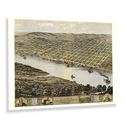 3 optionsAvailable in additional 3 options$3999current price $39.99
HISTORIX Vintage 1869 Leavenworth Kansas Map Print - 18x24 Inch Vintage Bird's Eye View of Leavenworth City Map of Kansas State Wall Art Poster
HISTORIX Vintage 1902 Eureka California Map Poster - 18x24 Inch Old Bird's Eye View of Eureka Humboldt County Map of California Poster Wall Art Print $39.99
 2 optionsAvailable in additional 2 options$3999current price $39.99
HISTORIX Vintage 1902 Eureka California Map Poster - 18x24 Inch Old Bird's Eye View of Eureka Humboldt County Map of California Poster Wall Art Print
HISTORIX 1886 Map of Chattanooga Tennessee Vintage Poster Wall Art Print, 18 x 24 Inch $39.99
 2 optionsAvailable in additional 2 options$3999current price $39.99
HISTORIX 1886 Map of Chattanooga Tennessee Vintage Poster Wall Art Print, 18 x 24 Inch
HISTORIX Vintage 1891 Great Falls Montana Map Poster - 18x24 Inch Bird's Eye View of Great Falls City Montana Map Wall Art - Old Wall Map of Montana $39.99
 2 optionsAvailable in additional 2 options$3999current price $39.99
HISTORIX Vintage 1891 Great Falls Montana Map Poster - 18x24 Inch Bird's Eye View of Great Falls City Montana Map Wall Art - Old Wall Map of Montana
HISTORIX Vintage 1869 Kankakee Illinois Map Poster - 18x24 Inch Old Map of Kankakee Illinois Wall Art - Bird's Eye View History Map of Illinois Poster $39.99
 2 optionsAvailable in additional 2 options$3999current price $39.99
HISTORIX Vintage 1869 Kankakee Illinois Map Poster - 18x24 Inch Old Map of Kankakee Illinois Wall Art - Bird's Eye View History Map of Illinois Poster
HISTORIX Vintage 1890 Map of Linguistic Stocks of American Indians Poster - Vintage Map of North America Wall Art - North America Map Print $39.99
 2 optionsAvailable in additional 2 options$3999current price $39.99
HISTORIX Vintage 1890 Map of Linguistic Stocks of American Indians Poster - Vintage Map of North America Wall Art - North America Map Print
HISTORIX Vintage 1900 Easton Pennsylvania & Phillipsburg New Jersey Map Print - 18x24 Inch Bird's Eye View of Easton PA & Phillipsburg NJ Map Poster $39.99
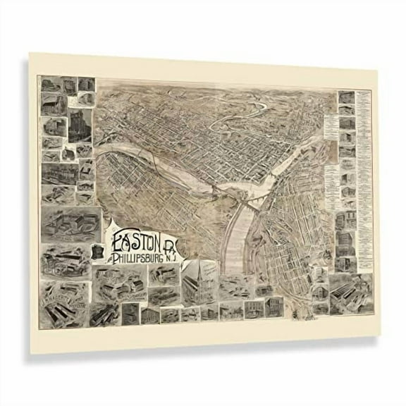 2 optionsAvailable in additional 2 options$3999current price $39.99
HISTORIX Vintage 1900 Easton Pennsylvania & Phillipsburg New Jersey Map Print - 18x24 Inch Bird's Eye View of Easton PA & Phillipsburg NJ Map Poster
HISTORIX 1777 Map of Boston Massachusetts Vintage Poster Wall Art Print, 18 x 24 Inch $39.99
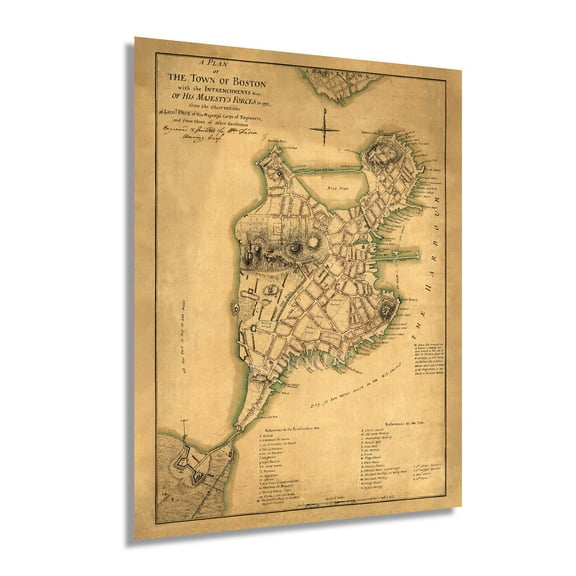 2 optionsAvailable in additional 2 options$3999current price $39.99
HISTORIX 1777 Map of Boston Massachusetts Vintage Poster Wall Art Print, 18 x 24 Inch
HISTORIX Vintage 1868 Iowa City Map - 18x24 Inch Bird's Eye View History Map of Iowa Poster - Old Iowa City Johnson County Iowa Map Poster Print $39.99
 2 optionsAvailable in additional 2 options$3999current price $39.99
HISTORIX Vintage 1868 Iowa City Map - 18x24 Inch Bird's Eye View History Map of Iowa Poster - Old Iowa City Johnson County Iowa Map Poster Print
1888 Map of Alabama - Vintage Map of Alabama Wall Art - Railroad Map of Alabama History Poster $39.99
 2 optionsAvailable in additional 2 options$3999current price $39.99
1888 Map of Alabama - Vintage Map of Alabama Wall Art - Railroad Map of Alabama History Poster
Customer ratings & reviews

Related pages
- Texas Oklahoma Map
- Alabama State Map Cities
- Maps Of Illinois Cities & Towns
- Gatlinburg Map
- Map Brattleboro Vt
- Alabama County Map Roads
- Central America Travel Books, Maps & Guides
- Midwest United States Travel Books, Maps & Guides
- Western United States Travel Books, Maps & Guides
- Northeast United States Travel Books, Maps & Guides
- National Parks Posters
- General South America Travel Books, Maps & Guides