Sorry, this item is out of stock
Browse similar items
C-MAP NA-M022 Max Wide SD Card East Coast And Bahamas $294.56
 $29456current price $294.56
C-MAP NA-M022 Max Wide SD Card East Coast And Bahamas
TestPlay 66 x 40 in. US Raised Relief Map - Extra Large $309.11
 $30911current price $309.11
TestPlay 66 x 40 in. US Raised Relief Map - Extra Large
BIGHORN RIVER, MONTANA GPS MAP $7.95
 $795current price $7.95
BIGHORN RIVER, MONTANA GPS MAP
California 3D Raised Relief Map $39.99
 $3999current price $39.99
California 3D Raised Relief Map
TestPlay 3073 36 x 18 in. Tennessee State Raised Relief Map, Framed - Large $170.81
 $17081current price $170.81
TestPlay 3073 36 x 18 in. Tennessee State Raised Relief Map, Framed - Large
Topographical Map - Cedar Mountain Texas Quad - USGS 1981 - 23 x 28.30 - Vintage Wall Art $94.95
 More options from$3695
Topographical Map - Cedar Mountain Texas Quad - USGS 1981 - 23 x 28.30 - Vintage Wall Art
Topographical Map - Busher Canyon Texas Quad - USGS 1968 - 23 x 27.38 - Vintage Wall Art $94.95
 More options from$3695
Topographical Map - Busher Canyon Texas Quad - USGS 1968 - 23 x 27.38 - Vintage Wall Art
BITTERROOT RIVER, MONTANA GPS MAP $7.95
 $795current price $7.95
BITTERROOT RIVER, MONTANA GPS MAP
Franko's Northern San Diego County Bikeways & Trails Map $8.88
 $888current price $8.88
Franko's Northern San Diego County Bikeways & Trails Map
BIGWOOD RIVER, IDAHO GPS MAP $7.95
 $795current price $7.95
BIGWOOD RIVER, IDAHO GPS MAP
Las Vegas 3D Raised Relief Map $39.99
 $3999current price $39.99
Las Vegas 3D Raised Relief Map
Clearance Xplorer Maps MAP_NC North Carolina State Hand-Drawn Map $15.52 Was $27.02
 $1552current price $15.52, Was $27.02$27.02
Xplorer Maps MAP_NC North Carolina State Hand-Drawn Map
Topographical Map - Willow Ranch California Quad - USGS 1962 - 23 x 30.16 - Vintage Wall Art $74.95
 More options from$3695
Topographical Map - Willow Ranch California Quad - USGS 1962 - 23 x 30.16 - Vintage Wall Art
San Diego County Waterproof Dive Map $12.95
 $1295current price $12.95
San Diego County Waterproof Dive Map
Central Sierra Trail Map $11.95
 $1195current price $11.95
Central Sierra Trail Map
Topographical Map - Eckley Colorado Quad - USGS 1961 - 23 x 30.36 - Vintage Wall Art $74.95
 More options from$3695
Topographical Map - Eckley Colorado Quad - USGS 1961 - 23 x 30.36 - Vintage Wall Art

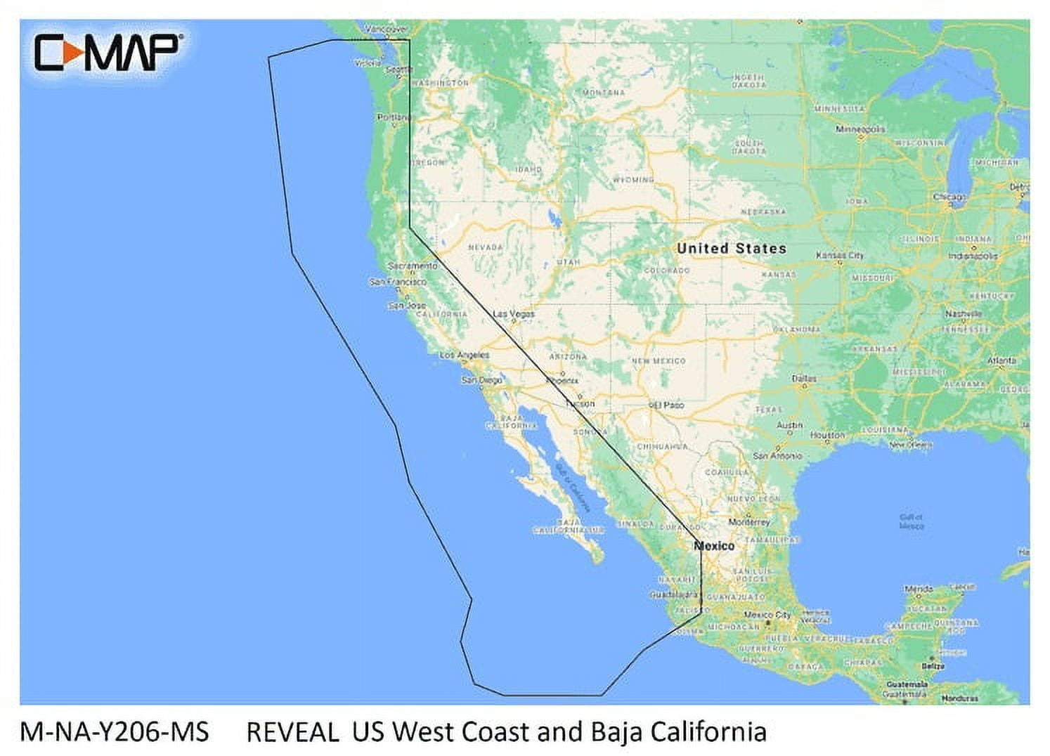
Hero image 0 of C-MAP Reveal Shaded Relief 3D Bathymetry US West Coast Baja California Map with microSD 34"x22", 0 of 1
C-MAP Reveal Shaded Relief 3D Bathymetry US West Coast Baja California Map with microSD 34"x22"
(No ratings yet)
Key item features
C-MAP Reveal Shaded Relief 3D Bathymetry US West Coast Baja California Map with microSD 34"x22"
- The shaded relief feature brings your surroundings to life with 3D rendered land and underwater elevations, enhancing navigational awareness
- UltraHighRes Bathymetric imagery is designed for anglers and divers, providing crucial details for optimal fishing and exploration
- Fullfeatured vector charts ensure accurate navigation with uptodate information sourced from official Hydrographic Offices, enhancing safety on the water
- Custom depth shading allows users to set a safety depth or maintain a paperlike view, improving clarity when navigating shallow areas
- Easy Routing™ automatically determines the shortest and safest route based on personalized vessel information, making navigation straightforward and efficient
Specs
- Size34" x 22"
- BrandC-MAP
- MaterialPaper
- FormBooks
- EditionStandard Edition
- ColorMulticolor
Current price is USD$249.90
Price when purchased online
Out of stock
How do you want your item?
Out of stock
About this item
Product details
C-MAP M-NA-Y206-MS Reveal Coastal US West Coast and Baja CaliforniaModel: M-NA-Y206-MSShaded Relief — bring the world around you to life, with 3D rendered land and underwater elevation — including areas of Ultra-High-Res Bathy seafloor imagery, previously only available in MAX-N+ Reveal a game changer for anglers.Full-Featured Vector Charts — making navigation easy by giving you accurate, up-to-date vector chart detail derive from official Hydrographic Office information.High-Res Bathy — helps you identify shallow areas, drop-offs, ledges, holes or humps. Now includes compiled and quality-controlled Genesis® detail as part of singular HRB layer.Custom Depth Shading — set a clear safety depth, maintain a paper-like view or create your own custom shading.Dynamic Raster Charts — providing the traditional chart look and feel, coupled with easy access to all objects on the chart.Easy Routing™ — helps you automatically plot the shortest, safest route based on detailed chart data and your personalized vessel information.Aerial Photography — a collection of thousands of photos of marinas, harbors, inlets and other notable navigational features included to offer an additional level of detail.Satellite Overlay — satellite imagery gives information about the surroundings when you find yourself in an unfamiliar place.Tides & Currents — shows projections of water level and direction of tides to help plan your day out, cruising, angling or sailing.Detailed Marina Port Plans — docking in an unfamiliar port is no problem when you have precise layouts of thousands of marinas, including slip spaces, restricted areas and other valuable navigation information.Harbor & Approach Details — unprecedented level of detail. Approach any harbor and inlet with confidence. The perfect conclusion to a long voyage, sailing adventure or an exciting day of fishing.Online Updates — keep your chart up to date, with 12 months’ free online updates.Cruising, fishing or sailing, C-MAP® REVEAL™ Coastal charts offer the very best of C-MAP. With Shaded Relief, including game-changing Reveal Seafloor Imagery, Aerial Photography, Satellite Overlay and Dynamic Raster Chart presentation added to the core C-MAP features found in DISCOVER™ — full-featured Vector Charts, with Custom Depth Shading, Tides & Currents and subscription-free Easy Routing™. It also includes the very best of C-MAP High-Res Bathy, including integrated Genesis® data. Purchase includes a full 12 months of free online updates. Compatible with Lowrance, Simrad & B&G Chartplotters.
C-MAP Reveal Shaded Relief 3D Bathymetry US West Coast Baja California Map with microSD 34"x22"
- The shaded relief feature brings your surroundings to life with 3D rendered land and underwater elevations, enhancing navigational awareness
- UltraHighRes Bathymetric imagery is designed for anglers and divers, providing crucial details for optimal fishing and exploration
- Fullfeatured vector charts ensure accurate navigation with uptodate information sourced from official Hydrographic Offices, enhancing safety on the water
- Custom depth shading allows users to set a safety depth or maintain a paperlike view, improving clarity when navigating shallow areas
- Easy Routing™ automatically determines the shortest and safest route based on personalized vessel information, making navigation straightforward and efficient
info:
We aim to show you accurate product information. Manufacturers, suppliers and others provide what you see here, and we have not verified it.
Specifications
Map type
Shaded Relief 3D Bathymetry
Subject
US West Coast Baja California
Size
34" x 22"
Brand
C-MAP
Warranty
Warranty information
Please be aware that the warranty terms on items offered for sale by third party Marketplace sellers may differ from those displayed in this section (if any). To confirm warranty terms on an item offered for sale by a third party Marketplace seller, please use the 'Contact seller' feature on the third party Marketplace seller's information page and request the item's warranty terms prior to purchase.
Popular items in this category
Best selling items that customers love
C-MAP Reveal Coastal Nova Scotia to Chesapeak Bay $249.90
 2 optionsAvailable in additional 2 options$24990current price $249.90
C-MAP Reveal Coastal Nova Scotia to Chesapeak Bay
Shipping, arrives in 3+ daysC-MAP Reveal Coastal Chesapeake Bay to the Bahamas M-NA-Y203-MS $249.90
 $24990current price $249.90
C-MAP Reveal Coastal Chesapeake Bay to the Bahamas M-NA-Y203-MS
Shipping, arrives in 3+ daysC-MAP Reveal US Lakes South East $169.99
 $16999current price $169.99
C-MAP Reveal US Lakes South East
Shipping, arrives in 3+ daysC-Map CMAMNAY204MS Reveal Coastal Gulf of Mexico & Bahamas $249.90 Was $283.65
 Now$24990current price Now $249.90, Was $283.65$283.65
C-Map CMAMNAY204MS Reveal Coastal Gulf of Mexico & Bahamas
Shipping, arrives in 3+ daysNational Geographic World Executive Map, Enlarged and Laminated, 73" x 48" $69.95 Was $80.07
 Now$6995current price Now $69.95, Was $80.07$80.07
National Geographic World Executive Map, Enlarged and Laminated, 73" x 48"
15 out of 5 Stars. 1 reviewsSave with Shipping, arrives in 3+ days
C-MAP Reveal Coastal Great Lakes to Nova Scotia $249.90
 $24990current price $249.90
C-MAP Reveal Coastal Great Lakes to Nova Scotia
Shipping, arrives in 3+ daysNational Geographic United States Classic Map, Laminated, 43.5" x 30.5" $41.91
 $4191current price $41.91
National Geographic United States Classic Map, Laminated, 43.5" x 30.5"
Shipping, arrives in 3+ daysWaypoint Geographic Blue Ocean World 24" x 36" Laminated Wall Map $37.28
 $3728current price $37.28
Waypoint Geographic Blue Ocean World 24" x 36" Laminated Wall Map
Shipping, arrives in 3+ daysNational Geographic The Dynamic Earth, Plate Tectonics Map, Laminated, 36" x 24" $29.55
 $2955current price $29.55
National Geographic The Dynamic Earth, Plate Tectonics Map, Laminated, 36" x 24"
Save withShipping, arrives in 3+ daysNational Geographic Africa Classic Map, Laminated, 24" x 30.75" $35.12
 $3512current price $35.12
National Geographic Africa Classic Map, Laminated, 24" x 30.75"
Shipping, arrives in 3+ daysNational Geographic World Executive Map, Mural, 110" x 76.5" $78.00
 $7800current price $78.00
National Geographic World Executive Map, Mural, 110" x 76.5"
Save withShipping, arrives in 3+ daysNational Geographic United States Classic Map, Enlarged and Laminated, 69.25" x 48" $67.21
 $6721current price $67.21
National Geographic United States Classic Map, Enlarged and Laminated, 69.25" x 48"
11 out of 5 Stars. 1 reviewsSave withShipping, arrives in 3+ daysNational Geographic United States Classic Map, Poster Size and Laminated, 36" x 24" $38.56
 $3856current price $38.56
National Geographic United States Classic Map, Poster Size and Laminated, 36" x 24"
Shipping, arrives in 3+ daysC-MAP Reveal US Lakes North East $179.00
 $17900current price $179.00
C-MAP Reveal US Lakes North East
Shipping, arrives in 3+ daysNational Geographic United States Decorator Map, Enlarged and Laminated, 43.5" x 30.5" $29.95
 $2995current price $29.95
National Geographic United States Decorator Map, Enlarged and Laminated, 43.5" x 30.5"
Save withShipping, arrives in 3+ daysDiscover North America Lakes US Canada $124.99
 $12499current price $124.99
Discover North America Lakes US Canada
Shipping, arrives in 3+ daysRand McNally Foldable Missouri State Map, 3.94 x 0.16 in $9.99
 $999current price $9.99
Rand McNally Foldable Missouri State Map, 3.94 x 0.16 in
15 out of 5 Stars. 1 reviewsSave withShipping, arrives in 3+ daysNational Geographic Reference Map: National Geographic England and Wales Wall Map - Classic - Laminated (30 X 36 In) (Other) $23.20
 $2320current price $23.20
National Geographic Reference Map: National Geographic England and Wales Wall Map - Classic - Laminated (30 X 36 In) (Other)
Save withShipping, arrives in 3+ daysBest Paved Roads in Southern California - Southern California G1 Series Map $21.95
 $2195current price $21.95+$4.99 shipping
Best Paved Roads in Southern California - Southern California G1 Series Map
Shipping, arrives in 3+ daysNational Geographic Reference Map: National Geographic World Wall Map - Classic - Laminated (Poster Size: 36 X 24 In) (Other) $26.58
 $2658current price $26.58
National Geographic Reference Map: National Geographic World Wall Map - Classic - Laminated (Poster Size: 36 X 24 In) (Other)
15 out of 5 Stars. 1 reviewsSave withShipping, arrives in 3+ days
Customer ratings & reviews
0 ratings|0 reviews
This item does not have any reviews yet
