Hero image 0 of National Geographic Maps RE01020414 Washington State Wall Map, 0 of 1
National Geographic Maps RE01020414 Washington State Wall Map
(No ratings yet)
Key item features
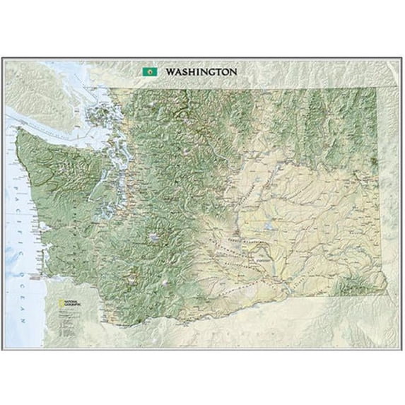
National Geographic proudly presents our new Washington State Wall Map, part of our growing series of State Wall Maps- Ideal for home or business, Washington is printed on a premium print quality stock ideal for framing or is also available in a durable laminated edition- Washington's diverse terrain and vegetation is rendered accurately through the map's color palate, shaded relief, and ocean bathymetry- Inherent to National Geographic reference cartography, the state wall maps contain thousands of place names and precise locations of: cities, major roadways and railways, airports, federal and state protected lands, mountain ranges and prominent peaks, marine sanctuaries, military installations, major lakes, rivers and reservoirs, and other geographic features- All state wall maps are printed in Ft- Collins, Colorado by a certified green printer using 10% recycled paper stock, low V-O-C- inks, and shipped less than 30 miles to our warehouse- Scale = 1:652,174- Projection = Albers Conic Equal Area Projection- Elevations and soundings in Feet- Standard: 41'' x 31''- SKU: NAGGR058
Specs
- FeaturesLaminated
- Size41" x 31".
- BrandNational Geographic
- MaterialPaper
Current price is USD$14.67
Price when purchased online
Out of stock
How do you want your item?
Out of stock
About this item
Product details
National Geographic proudly presents our new Washington State Wall Map, part of our growing series of State Wall Maps. Ideal for home or business, Washington is printed on a premium print quality stock ideal for framing or is also available in a durable laminated edition.
Washington's diverse terrain and vegetation is rendered accurately through the map's color palate, shaded relief, and ocean bathymetry. Inherent to National Geographic reference cartography, the state wall maps contain thousands of place names and precise locations of: cities, major roadways and railways, airports, federal and state protected lands, mountain ranges and prominent peaks, marine sanctuaries, military installations, major lakes, rivers and reservoirs, and other geographic features.
All state wall maps are printed in Ft. Collins, Colorado by a certified green printer using 10% recycled paper stock, low V.O.C. inks, and shipped less than 30 miles to our warehouse.
Scale = 1:652,174.
Projection = Albers Conic Equal Area Projection.
Elevations and soundings in Feet.
Standard: 41" x 31".- SKU: NAGGR058
Washington's diverse terrain and vegetation is rendered accurately through the map's color palate, shaded relief, and ocean bathymetry. Inherent to National Geographic reference cartography, the state wall maps contain thousands of place names and precise locations of: cities, major roadways and railways, airports, federal and state protected lands, mountain ranges and prominent peaks, marine sanctuaries, military installations, major lakes, rivers and reservoirs, and other geographic features.
All state wall maps are printed in Ft. Collins, Colorado by a certified green printer using 10% recycled paper stock, low V.O.C. inks, and shipped less than 30 miles to our warehouse.
National Geographic proudly presents our new Washington State Wall Map, part of our growing series of State Wall Maps- Ideal for home or business, Washington is printed on a premium print quality stock ideal for framing or is also available in a durable laminated edition- Washington's diverse terrain and vegetation is rendered accurately through the map's color palate, shaded relief, and ocean bathymetry- Inherent to National Geographic reference cartography, the state wall maps contain thousands of place names and precise locations of: cities, major roadways and railways, airports, federal and state protected lands, mountain ranges and prominent peaks, marine sanctuaries, military installations, major lakes, rivers and reservoirs, and other geographic features- All state wall maps are printed in Ft- Collins, Colorado by a certified green printer using 10% recycled paper stock, low V-O-C- inks, and shipped less than 30 miles to our warehouse- Scale = 1:652,174- Projection = Albers Conic Equal Area Projection- Elevations and soundings in Feet- Standard: 41'' x 31''- SKU: NAGGR058
info:
We aim to show you accurate product information. Manufacturers, suppliers and others provide what you see here, and we have not verified it.
Specifications
Features
Laminated
Size
41" x 31".
Brand
National Geographic
Material
Paper
Warranty
Warranty information
Warranty not available for this item
Please be aware that the warranty terms on items offered for sale by third party Marketplace sellers may differ from those displayed in this section (if any). To confirm warranty terms on an item offered for sale by a third party Marketplace seller, please use the 'Contact seller' feature on the third party Marketplace seller's information page and request the item's warranty terms prior to purchase.
Please be aware that the warranty terms on items offered for sale by third party Marketplace sellers may differ from those displayed in this section (if any). To confirm warranty terms on an item offered for sale by a third party Marketplace seller, please use the 'Contact seller' feature on the third party Marketplace seller's information page and request the item's warranty terms prior to purchase.
Warnings
Warning Text
proposition 65 reasons:titanium dioxide, other chemicals
Check out these related products
Historic City Map - Boston Massachusetts - Walling 1871 - Vintage Wall Art $36.95
 $3695current price $36.95
Historic City Map - Boston Massachusetts - Walling 1871 - Vintage Wall Art
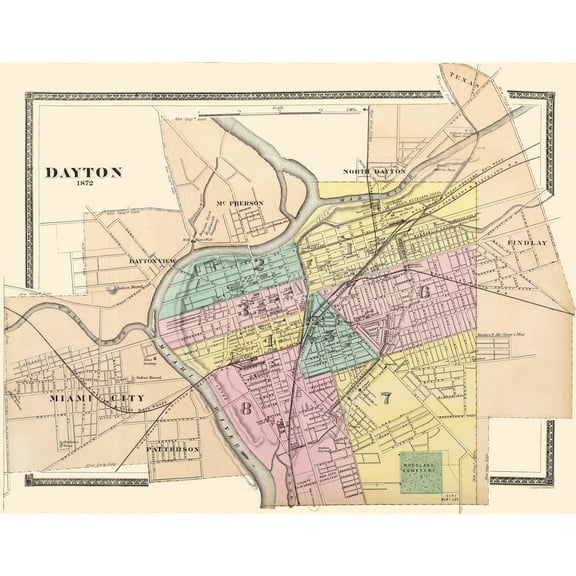
Historic City Map - Dayton Ohio - Walling 1876 - Vintage Wall Art $36.95
 $3695current price $36.95
Historic City Map - Dayton Ohio - Walling 1876 - Vintage Wall Art
Best seller 24x36 United States, USA, US Premier Wall Map Paper Folded $11.90
Best seller $1190current price $11.90
24x36 United States, USA, US Premier Wall Map Paper Folded
604.3 out of 5 Stars. 60 reviewsHistoric Panoramic View - Seattle Washington Business District - Tulloch 1903 - Vintage Wall Art $36.95
 $3695current price $36.95
Historic Panoramic View - Seattle Washington Business District - Tulloch 1903 - Vintage Wall Art
Univarsal 911100332001-63x54-SR2 63 x 54 in. Canada & World Essential Combo Classroom Wall Map - Spring Roller 2 $320.12
 $32012current price $320.12
Univarsal 911100332001-63x54-SR2 63 x 54 in. Canada & World Essential Combo Classroom Wall Map - Spring Roller 2
Historic State Map - California Nevada - 1872 - Vintage Wall Art $36.95
 $3695current price $36.95
Historic State Map - California Nevada - 1872 - Vintage Wall Art
Historic City Map - East Cleveland Collinsville Ohio - Titus 1874 - Vintage Wall Art $36.95
 $3695current price $36.95
Historic City Map - East Cleveland Collinsville Ohio - Titus 1874 - Vintage Wall Art
Customer ratings & reviews
0 ratings|0 reviews
This item does not have any reviews yet
