
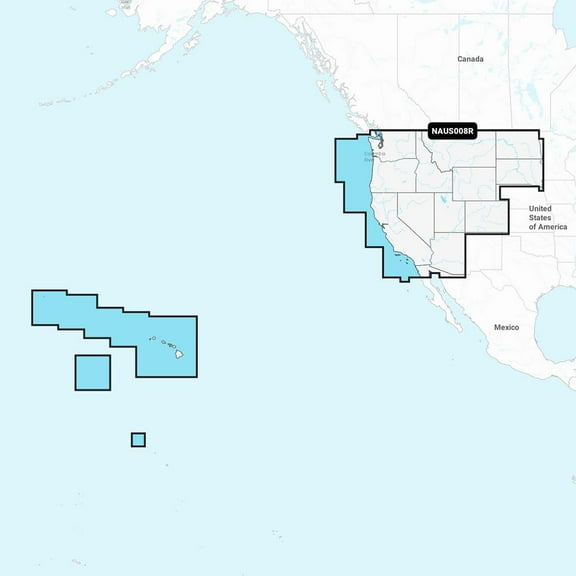
Garmin 010-C1371-40 US008R U.S. West Electronic Chart
Key item features
- Nautical Chart – Comprehensive charts are derived from multiple officials, government, and private sources, displayed in a familiar look and feel
- SonarChart HD Bathymetry - Innovative 1' (0.5 m) bathymetry charts are created by using Navionics proprietary systems that augment existing content with sonar data contributed by the boating community
- Community Edits - Get useful local knowledge from edits made by users of the Navionics Boating app on your compatible smart device.
- SonarChart Live Mapping Feature - Watch new HD depth maps develop in real-time as your boat moves through the water.
- Advanced Map Options - Customize your view to focus on the details that matter most
- Relief Shading - Get an easy-to-interpret, clearer view of bottom structure.
- Satellite Imagery with SonarChart Shading Overlay - Experience an enhanced awareness above and below the waterline.
- Sonar Imagery - View bottom hardness clearly and in contrasting color.
- 3D View - Adjust the perspective of your chart view to highlight key features and enhance awareness
- Aerial Photos - Get a better sense of your surroundings.
- Check the compatibility of Platinum+ content and features with your GPS chartplotter.
- Format - SD/MSD Card
- SD/MSD Card
- SKU : 0821245991782
- Condition : NEW
- MPN : 010C137140
Specs
- BrandNavionics
- SeriesPlatinum Plus
- Compatible OSGarmin
- AccessoriesSD/MSD Card
- Free shipping
 Free 15-day returns
How do you want your item?
About this item
Product details
Navionics Platinum+ NPUS008R U.S. West microSD
Model: 010-C1371-40- Integrated Garmin and Navionics® content provides exceptional coverage, clarity and detail in a familiar look and feel
- Easy access to daily chart updates is via the Navionics® Chart Installer software or wirelessly via the Plotter Sync feature with the Navionics Boating app (The Plotter Sync feature requires use of the Navionics Boating app on your compatible smart device with an active subscription of the same area.)
- Navionics® advanced dock-to-dock route guidance technology uses your boat settings, along with chart data and frequently traveled routes, to calculate a suggested path to follow (Route guidance is for planning purposes only and does not replace safe navigation operations.)
- High-resolution relief shading feature combines color and shadow to give you an easy-to-interpret, clearer view of bottom structure than contour lines alone
- High-resolution satellite imagery combined with SonarChart™ Shading overlay give you a realistic view of your surroundings — ideal for entering unfamiliar harbors or ports
- Sonar imagery is a downloadable image overlay that shows bottom hardness in contrasting color so you can easily identify transition areas on select U.S. lakes
- Aerial and surface photography of ports, marinas, bridges, docks, boat ramps, dams and navigational landmarks offers superior situational awareness
- Unique 3D views provide additional perspective both above and below the water
- Download the Community Edits content layer to any Navionics® card, and view this valuable, local information — contributed by Navionics Boating app users — on your compatible chartplotter
- For improved fishing and navigation, SonarChart™ HD bathymetry maps display up to 1’ (0.5 meter) contours, providing a more detailed depiction of bottom structure
- Fishing range advanced feature lets you highlight a user-defined target depth range
- To aid in navigation, the shallow water shading advanced feature highlights depths up to a user-defined level
- SonarChart™ Live mapping feature allows boaters to create new personal 1’ HD bathymetry maps that display in real time on the screens of their compatible plotters while navigating
Detailed coverage of the lakes, rivers and coasts of Arizona, California, Colorado, Idaho, Montana, Nevada, North Dakota, Oregon, South Dakota, Utah, Washington, and Wyoming, Hawaii, and the Johnston and Palmyra Atolls.
Get the world’s No. 1 choice in marine mapping (based on 2020 reported sales) — with the best, most up-to-date Navionics Platinum+™ premium marine cartography on your compatible chartplotter. For offshore or inland waters, this all-in-one solution offers detail-rich integrated mapping of coastal waters, lakes, rivers and more. Get 1’ (0.5 meter) HD contours, premier-grade chart features (depending on chartplotter model), including high-resolution relief shading, satellite imagery with SonarChart™ Shading overlay and 3D views, plus dock-to-dock route guidance technology, live mapping and Plotter Sync to provide wireless access to daily updates. The Navionics® Chart Installer software also ensures access to the freshest chart data every time out. Navionics route guidance solutions give you a suggested path to follow through channels, inlets, marina entrances and more. (Route guidance is for planning purposes only and does not replace safe navigation operations.) Multiple shading options aid in shallow water navigation and make it easy to highlight a target depth range for the best fishing spots.
- Nautical Chart – Comprehensive charts are derived from multiple officials, government, and private sources, displayed in a familiar look and feel
- SonarChart HD Bathymetry - Innovative 1' (0.5 m) bathymetry charts are created by using Navionics proprietary systems that augment existing content with sonar data contributed by the boating community
- Community Edits - Get useful local knowledge from edits made by users of the Navionics Boating app on your compatible smart device.
- SonarChart Live Mapping Feature - Watch new HD depth maps develop in real-time as your boat moves through the water.
- Advanced Map Options - Customize your view to focus on the details that matter most
- Relief Shading - Get an easy-to-interpret, clearer view of bottom structure.
- Satellite Imagery with SonarChart Shading Overlay - Experience an enhanced awareness above and below the waterline.
- Sonar Imagery - View bottom hardness clearly and in contrasting color.
- 3D View - Adjust the perspective of your chart view to highlight key features and enhance awareness
- Aerial Photos - Get a better sense of your surroundings.
- Check the compatibility of Platinum+ content and features with your GPS chartplotter.
- Format - SD/MSD Card
- SD/MSD Card
- SKU : 0821245991782
- Condition : NEW
- MPN : 010C137140
Specifications
Brand
Series
Model name
Compatible OS
Warranty
Warranty information
Similar items you might like
Garmin 010C126220 Sweden Lakes & Rivers Garmin Navio $169.94
 $16994current price $169.94
Garmin 010C126220 Sweden Lakes & Rivers Garmin Navio
Best seller Humminbird LakeMaster VX Premium - Great Lakes V1 [602002-1] $151.92
Best seller![Humminbird LakeMaster VX Premium - Great Lakes V1 [602002-1]](https://i5.walmartimages.com/asr/6a289db7-e281-4b43-8c91-8e0067400722.d42764d9b227226589732ea30635155b.jpeg?odnHeight=576&odnWidth=576&odnBg=FFFFFF) 12 optionsAvailable in additional 12 options$15192current price $151.92
12 optionsAvailable in additional 12 options$15192current price $151.92Humminbird LakeMaster VX Premium - Great Lakes V1 [602002-1]
1614.3 out of 5 Stars. 161 reviewsGarmin 010C123820 Mediterranean Sea Cen. & West Garm $169.94
 $16994current price $169.94
Garmin 010C123820 Mediterranean Sea Cen. & West Garm
Garmin 010C125220 Navionics NSEU053R - Norway $155.27
 $15527current price $155.27
Garmin 010C125220 Navionics NSEU053R - Norway
Garmin 010C121500 Japan Garmin Navionics Vision $209.99
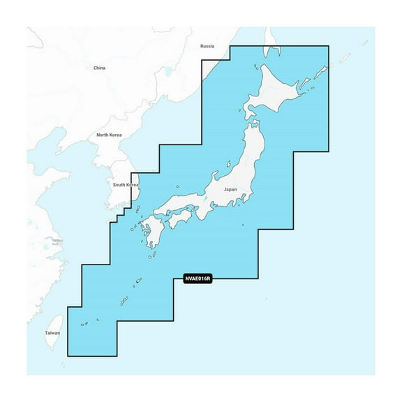 $20999current price $209.99
Garmin 010C121500 Japan Garmin Navionics Vision
Garmin 010C123020 Indian Subcontinent Garmin Navionic $156.74
 $15674current price $156.74
Garmin 010C123020 Indian Subcontinent Garmin Navionic
Garmin 010C124020 Aegean Sea Sea Of Marmara Garmin N $156.74
 $15674current price $156.74
Garmin 010C124020 Aegean Sea Sea Of Marmara Garmin N
Garmin 010C125200 Navionics Vision NVEU053R - Norway $259.99
 $25999current price $259.99
Garmin 010C125200 Navionics Vision NVEU053R - Norway
Garmin 010C125020 Norway Lista To Sognefjord Garmin $169.99
 $16999current price $169.99
Garmin 010C125020 Norway Lista To Sognefjord Garmin
Garmin 010C148320 Navionics Australia West & $250.97
 $25097current price $250.97
Garmin 010C148320 Navionics Australia West &
Garmin 010C124620 Iceland To Orkney Garmin Navionics $169.99
 $16999current price $169.99
Garmin 010C124620 Iceland To Orkney Garmin Navionics
Garmin 010C128320 Navionics New Zealand Marine Charts $129.61
 $12961current price $129.61
Garmin 010C128320 Navionics New Zealand Marine Charts
Garmin 010C125820 Black Sea & Azov Sea Garmin Navioni $156.74
 $15674current price $156.74
Garmin 010C125820 Black Sea & Azov Sea Garmin Navioni
Garmin 010C122420 Africa East Garmin Navionics $156.69
 $15669current price $156.69
Garmin 010C122420 Africa East Garmin Navionics
Garmin 010C123120 Great Britain Northeast Coast Garm $169.94
 $16994current price $169.94
Garmin 010C123120 Great Britain Northeast Coast Garm
Garmin 010C125100 Norway Sognefjord - Svefjorden Gar $259.99
 $25999current price $259.99
Garmin 010C125100 Norway Sognefjord - Svefjorden Gar
Garmin 010C123800 Mediterranean Sea Cen. & West Garm $238.14
 $23814current price $238.14
Garmin 010C123800 Mediterranean Sea Cen. & West Garm
Garmin 010C125920 Greenland Garmin Navionics $169.99
 $16999current price $169.99
Garmin 010C125920 Greenland Garmin Navionics
Garmin 010C123220 Irish Sea Garmin Navionics $156.69
 $15669current price $156.69
Garmin 010C123220 Irish Sea Garmin Navionics
Garmin 010C124600 Navionics Vision NVEU043R - Iceland to Orkney $234.69
 $23469current price $234.69
Garmin 010C124600 Navionics Vision NVEU043R - Iceland to Orkney
Check out these related products
Navionics Platinum NPUS007R - U.S. East $224.17
 $22417current price $224.17
Navionics Platinum NPUS007R - U.S. East
Garmin 010C128500 Navionics Vision Mexico Caribbean to Brazil Marine Charts $405.95
 $40595current price $405.95
Garmin 010C128500 Navionics Vision Mexico Caribbean to Brazil Marine Charts
Navionics Plus NAUS008R U.S. West microSD $148.46
 $14846current price $148.46
Navionics Plus NAUS008R U.S. West microSD
14 out of 5 Stars. 1 reviewsNavionics Platinum NPUS005R - U.S. North $240.97 Was $335.26
 $24097current price $240.97, Was $335.26$335.26
Navionics Platinum NPUS005R - U.S. North
Navionics Plus NAUS006R U.S. South microSD $150.01
 $15001current price $150.01
Navionics Plus NAUS006R U.S. South microSD
25 out of 5 Stars. 2 reviewsNavionics Plus NASA004L Mexico, Caribbean to Brazil microSD $189.88
 $18988current price $189.88
Navionics Plus NASA004L Mexico, Caribbean to Brazil microSD
Navionics Plus NAUS001L US and Coastal Canada microSD $180.99
 $18099current price $180.99
Navionics Plus NAUS001L US and Coastal Canada microSD
Navionics Platinum NPUS006R U.S. South microSD $245.30
 $24530current price $245.30
Navionics Platinum NPUS006R U.S. South microSD
11 out of 5 Stars. 1 reviewsNavionics Platinum NPSA010R - Central America Caribbean [010-C1459-40] $230.00 Was $343.09
![Navionics Platinum NPSA010R - Central America Caribbean [010-C1459-40]](https://i5.walmartimages.com/asr/5c6a6c35-c0be-4a03-9be2-b49259085489.6c779198883cabf7df8f00104c7eadd8.jpeg?odnHeight=576&odnWidth=576&odnBg=FFFFFF) $23000current price $230.00, Was $343.09$343.09
$23000current price $230.00, Was $343.09$343.09Navionics Platinum NPSA010R - Central America Caribbean [010-C1459-40]
Navionics Platinum NPSA004L - Mexico, Caribbean to Brazil $349.99
 $34999current price $349.99
Navionics Platinum NPSA004L - Mexico, Caribbean to Brazil
HUMMINBIRD LAKEMASTER VX PREMIUM DAKOTA/NEBRASKA $109.29
 $10929current price $109.29
HUMMINBIRD LAKEMASTER VX PREMIUM DAKOTA/NEBRASKA
15 out of 5 Stars. 1 reviewsBest seller Humminbird LakeMaster VX Premium Mid-South States Map 602005-1 $151.92
Best seller $15192current price $151.92
Humminbird LakeMaster VX Premium Mid-South States Map 602005-1
124.8 out of 5 Stars. 12 reviewsIcom M510 Plus VHF Fixed Mount Radio with AIS $757.16 Was $799.95
 $75716current price $757.16, Was $799.95$799.95
Icom M510 Plus VHF Fixed Mount Radio with AIS

