Hero image 0 of Railroad Map - Canadian Pacific Railway Connections - Poole 1912 - Vintage Wall Art, 0 of 4
Railroad Map - Canadian Pacific Railway Connections - Poole 1912 - Vintage Wall Art
(No ratings yet)
Railroad Map - Canadian Pacific Railway Connections - Poole 1912 - Vintage Wall ArtRailroad Map Canadian Pacific Railway Connections Poole 1912 23 x 40 Vintage Wall ArtRailroad Map Canadian Pacific Railway Connections Poole 1912 Vintage Wall ArtRailroad Map Canadian Pacific Railway Connections Poole 1912 23 x 40 Vintage Wall ArtRailroad Map Canadian Pacific Railway Connections Poole 1912 Vintage Wall Art
Material:Matte Art
Size:23.00 x 40.38
Key item features
- WHAT IS A RAILROAD SYSTEM? - Railroad systems were the original means of transporting both goods and people across the US, and many other countries across the globe. Railroads were built beginning in the 1800's and grew rapidly. They span coast to coast and are still heavily used today in many countries.
- ARE YOU A RAILROAD ENTHUSIAST? - If so, then add to your collection with prints of the original mappings of the railroad systems. Compare it against what is present today and see how much or how little it has changed since it's inceptions likely more than 100 years ago.
- ONLY ACCEPT THE BEST PRINT QUALITY FOR YOUR REPRODUCTIONS - There are many printers and print types available on the market, when purchasing a reproduction there is no finer quality reproduction than a reproduction using the Giclee Printing method. Giclee describes the technique or style of printing used, and it is revered as the highest quality printing because of the way it precisely sprays ink onto a surface. Trust nothing less than the best!
- GUARANTEED TO GET EXACTLY WHAT YOU ORDERED - All of our maps come rolled, wrapped, and shipped in a heavy gauge mailing tube to ensure it arrives intact.
- WHY CHOOSE MAPS OF THE PAST? - Maps of the Past is one of the single largest producers of different types of maps. They legally own the rights to the maps they sell, and provide them to you in clean, clear, and vibrant print. If you are looking for a high quality map print, then look no further than Maps of the Past!
Specs
- ColorMulticolor
- Decor styleIndustrial
- ThemeOld Railroad Maps
- FramedN
- ShapeRectangle
- Art typePhotography
Current price is USD$45.95
Price when purchased online
- Free shipping
 Free 30-day returns
How do you want your item?
Columbus, 43215
Arrives between Apr 18 - Apr 21
|Sold and shipped by Maps of the Past
4.3 stars out of 5, based on 10 seller reviews(4.3)10 seller reviews
Free 30-day returns
About this item
Product details
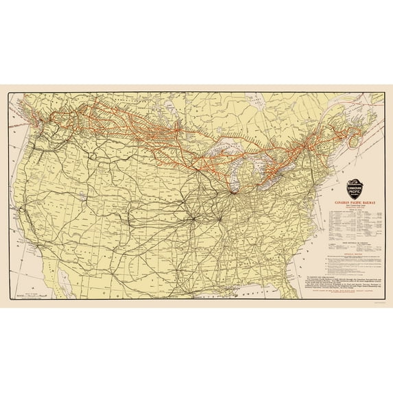
Old Railroad Map - Canadian Pacific Railway with Connections 1912 - This is an exquisite full-color Reproduction printed on gloss paper or art paper.
Sites and Townships Specific To This Map Are: Vancouver, Calgary, Winnipeg, Toronto, Montreal, McAdam, St Andrews, Quebec, New York, Chicago, Detroit, Chicago, Minneapolis, Kansas City, Denver, Cheyenne, Butte, Helena, Spokane, Seattle, Portland, and many more.
The following towns are featured: routes of the Canadian Pacific Railway and Connecting Lines. It encompasses the United States and Southern Canada. A table shows ticketing routes from St Paul via Vancouver, Spokane, All Rail, Kootenay, (and Kettle Valley), and Winnipeg. Another shows from Montreal or Toronto Direct and via Great Lakes. Option Routes are also listed. A notation states that the railway is built directly through the Canadian National Park and Rockies for scenic routes, as well as Puget Sound Steamships. Points shown on map in red, with black stars, indicate locations of Canadian Pacific Hotels.
This Map is Situated in: Canada and United States, North America.
SKU: ITNA0036
Original Maps are often difficult to find and usually have fold lines, identifying stamps or markings, tears, ragged edges, and assorted other natural signs of age that detract from their beauty. All of our maps have been professionally restored to depict their original beauty, while keeping all historical data intact.
These maps are fabulous pieces of history full of information useful to Historians, Genealogists, Cartographers, Relic Hunters, & Others. They make fascinating conversation pieces and splendid works of art for the home or office.
- WHAT IS A RAILROAD SYSTEM? - Railroad systems were the original means of transporting both goods and people across the US, and many other countries across the globe. Railroads were built beginning in the 1800's and grew rapidly. They span coast to coast and are still heavily used today in many countries.
- ARE YOU A RAILROAD ENTHUSIAST? - If so, then add to your collection with prints of the original mappings of the railroad systems. Compare it against what is present today and see how much or how little it has changed since it's inceptions likely more than 100 years ago.
- ONLY ACCEPT THE BEST PRINT QUALITY FOR YOUR REPRODUCTIONS - There are many printers and print types available on the market, when purchasing a reproduction there is no finer quality reproduction than a reproduction using the Giclee Printing method. Giclee describes the technique or style of printing used, and it is revered as the highest quality printing because of the way it precisely sprays ink onto a surface. Trust nothing less than the best!
- GUARANTEED TO GET EXACTLY WHAT YOU ORDERED - All of our maps come rolled, wrapped, and shipped in a heavy gauge mailing tube to ensure it arrives intact.
- WHY CHOOSE MAPS OF THE PAST? - Maps of the Past is one of the single largest producers of different types of maps. They legally own the rights to the maps they sell, and provide them to you in clean, clear, and vibrant print. If you are looking for a high quality map print, then look no further than Maps of the Past!
info:
We aim to show you accurate product information. Manufacturers, suppliers and others provide what you see here, and we have not verified it.
Specifications
Color
Multicolor
Decor style
Industrial
Theme
Old Railroad Maps
Framed
N
Warranty
Warranty information
Please be aware that the warranty terms on items offered for sale by third party Marketplace sellers may differ from those displayed in this section (if any). To confirm warranty terms on an item offered for sale by a third party Marketplace seller, please use the 'Contact seller' feature on the third party Marketplace seller's information page and request the item's warranty terms prior to purchase.
Similar items you might like
Based on what customers bought
Railroad Map - Railroad Routes Illinois - McEwen 1897 - 23 x 38.51 - Vintage Wall Art $94.95 $94.95/count
 $9495current price $94.95$94.95/count
Railroad Map - Railroad Routes Illinois - McEwen 1897 - 23 x 38.51 - Vintage Wall Art
Railroad Map - Hillsborough and Cincinnati Railroad - Jacobil 1853 - 23 x 59 - Vintage Wall Art $94.95
 $9495current price $94.95
Railroad Map - Hillsborough and Cincinnati Railroad - Jacobil 1853 - 23 x 59 - Vintage Wall Art
Railroad Map - United States Eastern Railroad Telegraph Stage - Disturnell 1850 - 23 x 29 - Vintage Wall Art $94.95
 3 optionsAvailable in additional 3 options$9495current price $94.95
Railroad Map - United States Eastern Railroad Telegraph Stage - Disturnell 1850 - 23 x 29 - Vintage Wall Art
Old Travel Map - Alaska Excursion Steamers, N Pacific Railroad 1891 - 23 x 47 $94.95 $94.95/count
 2 optionsAvailable in additional 2 options$9495current price $94.95$94.95/count
Old Travel Map - Alaska Excursion Steamers, N Pacific Railroad 1891 - 23 x 47
Historic State Map - California - 1650 - 23 x 32.68 - Vintage Wall Art $94.95
 $9495current price $94.95
Historic State Map - California - 1650 - 23 x 32.68 - Vintage Wall Art
Historic Nautical Map - New England Coast - 1776 - 23 x 32.81 - Vintage Wall Art $94.95 $94.95/count
 3 optionsAvailable in additional 3 options$9495current price $94.95$94.95/count
Historic Nautical Map - New England Coast - 1776 - 23 x 32.81 - Vintage Wall Art
Historic Nautical Map - Pacific Coast Steamship Company Routes - 1891 - 23 x 46.07 - Vintage Wall Art $94.95 $94.95/count
 3 optionsAvailable in additional 3 options$9495current price $94.95$94.95/count
Historic Nautical Map - Pacific Coast Steamship Company Routes - 1891 - 23 x 46.07 - Vintage Wall Art
Historic City Map - Lynn Massachusetts - Walling 1871 - 23 x 29.18 - Vintage Wall Art $94.95 $94.95/count
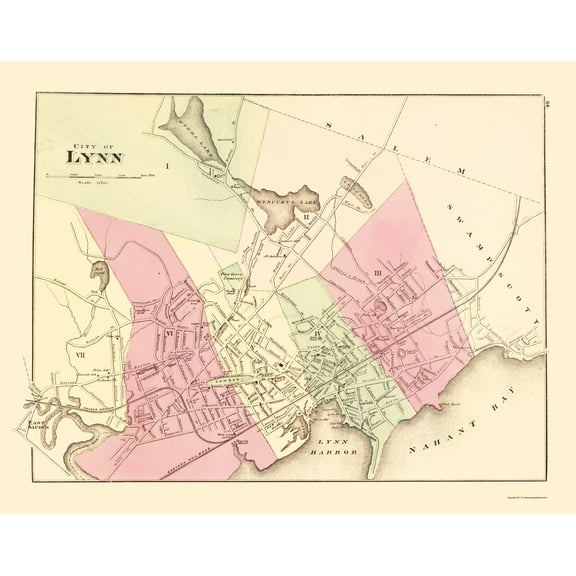 $9495current price $94.95$94.95/count
Historic City Map - Lynn Massachusetts - Walling 1871 - 23 x 29.18 - Vintage Wall Art
Topographical Map - Rhode Island Sheet 1 - USGS 1891 - 23 x 30.02 - Vintage Wall Art $94.95 $94.95/count
 $9495current price $94.95$94.95/count
Topographical Map - Rhode Island Sheet 1 - USGS 1891 - 23 x 30.02 - Vintage Wall Art
Historic Revolutionary War Map - North America Canada - Covens 1757 - 23 x 32 - Vintage Wall Art $94.95 $94.95/count
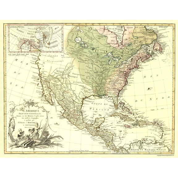 $9495current price $94.95$94.95/count
Historic Revolutionary War Map - North America Canada - Covens 1757 - 23 x 32 - Vintage Wall Art
Historic Map - British Isles - Stieler 1852 - 23 x 27.94 - Vintage Wall Art $94.95 $94.95/count
 $9495current price $94.95$94.95/count
Historic Map - British Isles - Stieler 1852 - 23 x 27.94 - Vintage Wall Art
Railroad Map - Yellowstone National Park - Northern Pacific 1910 - 23 x 25 - Vintage Wall Art $40.95
 3 optionsAvailable in additional 3 options$4095current price $40.95
Railroad Map - Yellowstone National Park - Northern Pacific 1910 - 23 x 25 - Vintage Wall Art
Historic State Map - Colorado - Thayer 1880 - 23 x 28.78 - Vintage Wall Art $94.95 $94.95/count
 $9495current price $94.95$94.95/count
Historic State Map - Colorado - Thayer 1880 - 23 x 28.78 - Vintage Wall Art
Railroad Map - Boston and Maine Railroad - Avery 1888 - Vintage Wall Art $45.95 $45.95/count
 4 optionsAvailable in additional 4 options$4595current price $45.95$45.95/count
Railroad Map - Boston and Maine Railroad - Avery 1888 - Vintage Wall Art
Railroad Map - New York City IRT Routes - 1924 - 23 x 39.01 - Vintage Wall Art $40.95 $40.95/count
 3 optionsAvailable in additional 3 options$4095current price $40.95$40.95/count
Railroad Map - New York City IRT Routes - 1924 - 23 x 39.01 - Vintage Wall Art
Historic State Map - Virginia - Burr 1834 - 28.13 x 23 - Vintage Wall Art $94.95 $94.95/count
 3 optionsAvailable in additional 3 options$9495current price $94.95$94.95/count
Historic State Map - Virginia - Burr 1834 - 28.13 x 23 - Vintage Wall Art
Historic City Map - Nantucket Island Massachusetts - Bouve 1838 - 23 x 32.64 - Vintage Wall Art $40.95 $40.95/count
 $4095current price $40.95$40.95/count
Historic City Map - Nantucket Island Massachusetts - Bouve 1838 - 23 x 32.64 - Vintage Wall Art
Railroad Map - Union Pacific Railway - Colton 1882 - 23 x 33.13 - Vintage Wall Art $40.95 $40.95/count
 3 optionsAvailable in additional 3 options$4095current price $40.95$40.95/count
Railroad Map - Union Pacific Railway - Colton 1882 - 23 x 33.13 - Vintage Wall Art
Railroad Map - Florida State Railway Counties - Grant 1889 - 23 x 30.98 - Vintage Wall Art $40.95 $40.95/count
 $4095current price $40.95$40.95/count
Railroad Map - Florida State Railway Counties - Grant 1889 - 23 x 30.98 - Vintage Wall Art

Customer ratings & reviews
0 ratings|0 reviews
This item does not have any reviews yet
