Hero image 0 of Historic Map - New Spain Mexico Indian Tribe - Humboldt 1804 - Vintage Wall Art, 0 of 4
Historic Map - New Spain Mexico Indian Tribe - Humboldt 1804 - Vintage Wall Art
(No ratings yet)
Historic Map - New Spain Mexico Indian Tribe - Humboldt 1804 - Vintage Wall ArtHistoric Map New Spain Mexico Indian Tribe Humboldt 1804 23 x 33 Vintage Wall ArtHistoric Map New Spain Mexico Indian Tribe Humboldt 1804 Vintage Wall ArtHistoric Map New Spain Mexico Indian Tribe Humboldt 1804 Vintage Wall ArtHistoric Map New Spain Mexico Indian Tribe Humboldt 1804 23 x 33 Vintage Wall Art
Material:Glossy Photo
Size:23.00 x 33.24
Key item features
- OWN A PIECE OF YOUR HOME COUNTRY - Looking for something that reminds you of the country you or your ancestors originate from? Well now you can own a piece of your heritage with a beautiful map of your home country. Maps of the Past has maps for every need!
- INTERNATIONAL MAPS PROVIDE IMPORTANT INFORMATION - International maps not only show you how the different countries, cities, counties, and territories are divided and where the borders can be found, but it also highlights rivers, mountains, and other natural elements of the land. International maps can also show you natural resources and exports of a country.
- ONLY ACCEPT THE BEST PRINT QUALITY FOR YOUR REPRODUCTIONS - There are many printers and print types available on the market, when purchasing a reproduction there is no finer quality reproduction than a reproduction using the Giclee Printing method. Giclee describes the technique or style of printing used, and it is revered as the highest quality printing because of the way it precisely sprays ink onto a surface. Trust nothing less than the best!
- GUARANTEED TO GET EXACTLY WHAT YOU ORDERED - All of our maps come rolled, wrapped, and shipped in a heavy gauge mailing tube to ensure it arrives intact.
- WHY CHOOSE MAPS OF THE PAST? - Maps of the Past is one of the single largest producers of different types of maps. They legally own the rights to the maps they sell, and provide them to you in clean, clear, and vibrant print. If you are looking for a high quality map print, then look no further than Maps of the Past!
Specs
- ColorMulticolor
- Decor styleIndustrial
- FramedN
- ShapeRectangle
- Art typePhotography
- Rec. roomOffice
Current price is USD$40.95$40.95/count
Price when purchased online
- Free shipping
 Free 30-day returns
How do you want your item?
Columbus, 43215
Arrives by Tue, Apr 21
|Sold and shipped by Maps of the Past
4.3 stars out of 5, based on 10 seller reviews(4.3)10 seller reviews
Free 30-day returns - in store or online
About this item
Product details
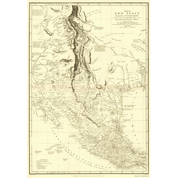
Old Caribbean Map - New Spain Map with Indian Tribe Details 1804 - This is an exquisite full-color Reproduction printed on gloss paper or art paper.
Sites and Townships Specific To This Map Are: Monterey, Reinoso, Monterrey. Mazatlan, Acaponeta, Sombrerere, Zacatula, Guadalaxara, Mazatlan, Acaponeta, Durango, Chihuahua, Santa Fe and many more.
The following towns are featured: Highly detailed Native American map of what is now Louisiana, Texas, New Mexico, Nevada and Mexico. A few of the many tribes included are the Yamparicas, Apache Mescalero, Apaches Llaueros, Yabipias (with long beards), Comanches and many more. Other features include the Sea of Cortez, Sonora, Gulf of Mexico, Bolson de Mapima, Nuevo Reyno de Leon, Lake Timpanogos, Sierra de Timpanogos, Old California, Great Northern Sea, Chapala Lake, Trinity Lake, Arkansas River, Red River, Sabine River, Galveston Bay, Mines, Hacienda Farms, Rancho - Station of Muleteers, Presidio - Military Post and includes many notated facts throughout this map (ex. First abode of the Aztecs, come from Aztlan in 1160. Tradition uncertain).
This Map is Situated in: North America /
SKU: ITNA0005
Original Maps are often difficult to find and usually have fold lines, identifying stamps or markings, tears, ragged edges, and assorted other natural signs of age that detract from their beauty. All of our maps have been professionally restored to depict their original beauty, while keeping all historical data intact.
These maps are fabulous pieces of history full of information useful to Historians, Genealogists, Cartographers, Relic Hunters, & Others. They make fascinating conversation pieces and splendid works of art for the home or office.
- OWN A PIECE OF YOUR HOME COUNTRY - Looking for something that reminds you of the country you or your ancestors originate from? Well now you can own a piece of your heritage with a beautiful map of your home country. Maps of the Past has maps for every need!
- INTERNATIONAL MAPS PROVIDE IMPORTANT INFORMATION - International maps not only show you how the different countries, cities, counties, and territories are divided and where the borders can be found, but it also highlights rivers, mountains, and other natural elements of the land. International maps can also show you natural resources and exports of a country.
- ONLY ACCEPT THE BEST PRINT QUALITY FOR YOUR REPRODUCTIONS - There are many printers and print types available on the market, when purchasing a reproduction there is no finer quality reproduction than a reproduction using the Giclee Printing method. Giclee describes the technique or style of printing used, and it is revered as the highest quality printing because of the way it precisely sprays ink onto a surface. Trust nothing less than the best!
- GUARANTEED TO GET EXACTLY WHAT YOU ORDERED - All of our maps come rolled, wrapped, and shipped in a heavy gauge mailing tube to ensure it arrives intact.
- WHY CHOOSE MAPS OF THE PAST? - Maps of the Past is one of the single largest producers of different types of maps. They legally own the rights to the maps they sell, and provide them to you in clean, clear, and vibrant print. If you are looking for a high quality map print, then look no further than Maps of the Past!
info:
We aim to show you accurate product information. Manufacturers, suppliers and others provide what you see here, and we have not verified it.
Specifications
Color
Multicolor
Decor style
Industrial
Theme
Historical International Maps
Framed
N
Warranty
Warranty information
Please be aware that the warranty terms on items offered for sale by third party Marketplace sellers may differ from those displayed in this section (if any). To confirm warranty terms on an item offered for sale by a third party Marketplace seller, please use the 'Contact seller' feature on the third party Marketplace seller's information page and request the item's warranty terms prior to purchase.
Similar items you might like
Based on what customers bought
In 50+ people's carts Home Decor Collection Gold Metro Beaded Oval Framed Landscape Wall Art, Vintage-Style Décor for Living Room, Entryway, Bedroom, or Office, 14x11 $7.49
In 50+ people's carts $749current price $7.49
Home Decor Collection Gold Metro Beaded Oval Framed Landscape Wall Art, Vintage-Style Décor for Living Room, Entryway, Bedroom, or Office, 14x11
1774.4 out of 5 Stars. 177 reviewsHistoric State Map - America Septentrionali - 1751 - 26.63 x 23 - Vintage Wall Art $40.95 $40.95/count
 3 optionsAvailable in additional 3 options$4095current price $40.95$40.95/count
Historic State Map - America Septentrionali - 1751 - 26.63 x 23 - Vintage Wall Art
Historic State Map - Missouri - Cram 1875 - Vintage Wall Art $36.95
 $3695current price $36.95
Historic State Map - Missouri - Cram 1875 - Vintage Wall Art
Historic State Map - Idaho - Rathbun 1893 - 23 x 28.59 - Vintage Wall Art $45.95 $45.95/count
 4 optionsAvailable in additional 4 options$4595current price $45.95$45.95/count
Historic State Map - Idaho - Rathbun 1893 - 23 x 28.59 - Vintage Wall Art
Historic State Map - New York Planning - 1873 - 23 x 34.09 - Vintage Wall Art $40.95
 4 optionsAvailable in additional 4 options$4095current price $40.95
Historic State Map - New York Planning - 1873 - 23 x 34.09 - Vintage Wall Art
Historic City Map - San Antonio Texas - Ashburn 1950 - 23 x 28.71 - Vintage Wall Art $45.95 $45.95/count
 3 optionsAvailable in additional 3 options$4595current price $45.95$45.95/count
Historic City Map - San Antonio Texas - Ashburn 1950 - 23 x 28.71 - Vintage Wall Art
Historic City Map - Natchez Mississippi - Collot 1796 - Vintage Wall Art $36.95
 4 optionsAvailable in additional 4 options$3695current price $36.95
Historic City Map - Natchez Mississippi - Collot 1796 - Vintage Wall Art
Historic Map - Africa Eastern - Blaeu 1635 - Vintage Wall Art $36.95
 $3695current price $36.95
Historic Map - Africa Eastern - Blaeu 1635 - Vintage Wall Art
Historic Map - North America - Smiley 1842 - Vintage Wall Art $36.95
 3 optionsAvailable in additional 3 options$3695current price $36.95
Historic Map - North America - Smiley 1842 - Vintage Wall Art
Historic State Map - Florida - Mitchell 1846 - Vintage Wall Art $36.95
 4 optionsAvailable in additional 4 options$3695current price $36.95
Historic State Map - Florida - Mitchell 1846 - Vintage Wall Art
Historic Map - North South America - Seutter 1745 - 26 x 23 - Vintage Wall Art $45.95 $45.95/count
 $4595current price $45.95$45.95/count
Historic Map - North South America - Seutter 1745 - 26 x 23 - Vintage Wall Art
Historic State Map - Texas - Mead 1903 - 23 x 27.03 - Vintage Wall Art $40.95 $40.95/count
 $4095current price $40.95$40.95/count
Historic State Map - Texas - Mead 1903 - 23 x 27.03 - Vintage Wall Art
Historic Map - North America Region Mexico Florida United States - Vindel 1732 - 23 x 27 - Vintage Wall Art $40.95 $40.95/count
 3 optionsAvailable in additional 3 options$4095current price $40.95$40.95/count
Historic Map - North America Region Mexico Florida United States - Vindel 1732 - 23 x 27 - Vintage Wall Art
Topographical Map - San Juan Bautista California Quad - USGS 1940 - Vintage Wall Art $36.95
 $3695current price $36.95
Topographical Map - San Juan Bautista California Quad - USGS 1940 - Vintage Wall Art
Historic Map - Arabian Peninsula- Blaeu 1662 - 23 x 28.50 - Vintage Wall Art $40.95 $40.95/count
 4 optionsAvailable in additional 4 options$4095current price $40.95$40.95/count
Historic Map - Arabian Peninsula- Blaeu 1662 - 23 x 28.50 - Vintage Wall Art
Historic State Map - New York - Lucas 1823 - 32 x 23 - Vintage Wall Art $45.95 $45.95/count
 $4595current price $45.95$45.95/count
Historic State Map - New York - Lucas 1823 - 32 x 23 - Vintage Wall Art
Historic Map - Africa - Thomson 1821 - Vintage Wall Art $36.95
 4 optionsAvailable in additional 4 options$3695current price $36.95
Historic Map - Africa - Thomson 1821 - Vintage Wall Art
Historic Map - Mexico - Arrowsmith 1844 - Vintage Wall Art $36.95
 $3695current price $36.95
Historic Map - Mexico - Arrowsmith 1844 - Vintage Wall Art
Historic Map - United States Mexico Canada - Andreas 1873 - 23 x 35 - Vintage Wall Art $45.95 $45.95/count
 4 optionsAvailable in additional 4 options$4595current price $45.95$45.95/count
Historic Map - United States Mexico Canada - Andreas 1873 - 23 x 35 - Vintage Wall Art
Historic State Map - Texas Part of Mexico - Desilver 1861 - 23 x 29.87 - Vintage Wall Art $40.95 $40.95/count
 $4095current price $40.95$40.95/count
Historic State Map - Texas Part of Mexico - Desilver 1861 - 23 x 29.87 - Vintage Wall Art
Customer ratings & reviews
0 ratings|0 reviews
This item does not have any reviews yet
